MCD15A3H.006 MODIS Leaf Area Index/FPAR 4-Day Global 500m [deprecated]
Stay organized with collections
Save and categorize content based on your preferences.
Page Summary
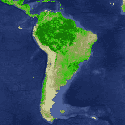
This dataset contains Combined Fraction of Photosynthetically Active Radiation (FPAR) and Leaf Area Index (LAI) data at a 500-meter pixel size.
The dataset is a 4-day composite using the "best" pixel from both Terra and Aqua MODIS sensors.
Data is available from July 2002 to February 2023.
This dataset has been superseded by MODIS/061/MCD15A3H.
There are no restrictions on the subsequent use, sale, or redistribution of this data.
The MCD15A3H V6 level 4, Combined Fraction of Photosynthetically
Active Radiation (FPAR), and Leaf Area Index (LAI) product is a
4-day composite data set with 500 meter pixel size. The algorithm
chooses the "best" pixel available from all the acquisitions of
both MODIS sensors located on NASA's Terra and Aqua satellites
from within the 4-day period.
FPAR absorbed by the green elements of a vegetation canopy
Lai
0
100
0.1
500 meters
None
One-sided green leaf area per unit ground area in
broadleaf canopies; one-half the total needle surface area per
unit ground area in coniferous canopies
FparLai_QC
500 meters
None
Quality for Lai and Fpar
Bitmask for FparLai_QC
Bit 0: MODLAND_QC bits
0: Good quality (main algorithm with or without saturation)
1: Other quality (back-up algorithm or fill values)
Bit 1: Sensor
0: Terra
1: Aqua
Bit 2: Dead detector
0: Detectors apparently fine for up to 50% of channels 1, 2
1: Dead detectors caused >50% adjacent detector retrieval
Bits 3-4: Cloud state
0: Significant clouds NOT present (clear)
1: Significant clouds WERE present
2: Mixed cloud present in pixel
3: Cloud state not defined, assumed clear
Bits 5-7: SCF_QC
0: Main (RT) method used with no saturation, best result possible
1: Main (RT) method used with saturation, good and very usable
2: Main (RT) method failed due to bad geometry, empirical algorithm used
3: Main (RT) method failed due to problems other
than geometry, empirical algorithm used
4: Pixel not produced at all, value couldn''t
be retrieved (possible reasons: bad L1B data, unusable
MOD09GA data)
FparExtra_QC
500 meters
None
Extra detail quality for LAI and FPAR
Bitmask for FparExtra_QC
Bits 0-1: Land-sea pass-thru
0: LAND
1: SHORE
2: FRESHWATER
3: OCEAN
Bit 2: Snow ice
0: No snow/ice detected
1: Snow/ice detected
Bit 3: Aerosol
0: No or low atmospheric aerosol levels detected
1: Average or high aerosol levels detected
Bit 4: Cirrus
0: No cirrus detected
1: Cirrus detected
Bit 5: Internal cloud mask
0: No clouds
1: Clouds were detected
Bit 6: Cloud shadow
0: No cloud shadow detected
1: Cloud shadow detected
Bit 7: SCF biome mask
0: Biome outside interval <1,4>
1: Biome in interval <1,4>
FparStdDev
0
100
0.01
500 meters
None
Standard deviation of Fpar
LaiStdDev
0
100
0.1
500 meters
None
Standard deviation for Lai
Terms of Use
Terms of Use
MODIS data and products acquired through the LP DAAC
have no restrictions on subsequent use, sale, or redistribution.
The MCD15A3H V6 level 4, Combined Fraction of Photosynthetically Active Radiation (FPAR), and Leaf Area Index (LAI) product is a 4-day composite data set with 500 meter pixel size. The algorithm chooses the "best" pixel available from all the acquisitions of both MODIS sensors located on NASA's Terra and Aqua …
[[["Easy to understand","easyToUnderstand","thumb-up"],["Solved my problem","solvedMyProblem","thumb-up"],["Other","otherUp","thumb-up"]],[["Missing the information I need","missingTheInformationINeed","thumb-down"],["Too complicated / too many steps","tooComplicatedTooManySteps","thumb-down"],["Out of date","outOfDate","thumb-down"],["Samples / code issue","samplesCodeIssue","thumb-down"],["Other","otherDown","thumb-down"]],[],[],["This dataset provides 4-day composite data from 2002-07-04 to 2023-02-14 at a 500-meter pixel size, focusing on the Fraction of Photosynthetically Active Radiation (FPAR) and Leaf Area Index (LAI). It uses \"best\" pixel selection from NASA's Terra and Aqua satellites. The dataset includes quality control data and standard deviation metrics, all accessible via an Earth Engine snippet. Notably, this dataset is superseded by MODIS/061/MCD15A3H.\n"]]