In Lettland werden Orthophotokarten im lettischen Koordinatensystem LKS-92 TM gemäß der TKS-93-Kartenblattteilung erstellt (ein Kartenblatt im Maßstab 1:10.000 entspricht 5 × 5 Kilometern in der Natur). Orthophotokarten werden für das gesamte Gebiet Lettlands im Maßstab 1:10.000 erstellt, für separate Gebiete wie Städte und dicht besiedelte Gebiete im Maßstab 1:2.000 oder 1:1.000.
Das RGB-Dataset hat drei Bänder: rot, grün und blau.
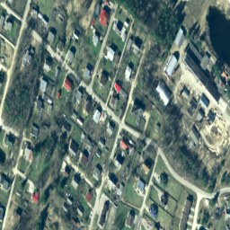
In Lettland werden Orthophotokarten im lettischen Koordinatensystem LKS-92 TM gemäß der TKS-93-Kartenblattunterteilung erstellt (ein Kartenblatt im Maßstab 1:10000 entspricht 5 × 5 Kilometern in der Natur). Orthophotokarten werden für das gesamte Gebiet Lettlands im Maßstab 1:10000 erstellt, aber für separate …
[[["Leicht verständlich","easyToUnderstand","thumb-up"],["Mein Problem wurde gelöst","solvedMyProblem","thumb-up"],["Sonstiges","otherUp","thumb-up"]],[["Benötigte Informationen nicht gefunden","missingTheInformationINeed","thumb-down"],["Zu umständlich/zu viele Schritte","tooComplicatedTooManySteps","thumb-down"],["Nicht mehr aktuell","outOfDate","thumb-down"],["Problem mit der Übersetzung","translationIssue","thumb-down"],["Problem mit Beispielen/Code","samplesCodeIssue","thumb-down"],["Sonstiges","otherDown","thumb-down"]],[],[],["The dataset provides Latvia's orthophoto maps from 2007 to 2018, available via Google Earth Engine. These RGB images, sourced from the Latvian Geospatial Information Agency, cover all of Latvia at a 1:10000 scale, with higher resolutions for urban areas. The dataset, in LKS-92 TM coordinates, has 0.2-meter pixel size and offers red, green, and blue bands (0-255 range). Access the dataset using the `ee.ImageCollection(\"Latvia/Maamet/orthos/rgb\")` code snippet.\n"]]