Latvia Color InfraRed (CIR) orthophotos
Mit Sammlungen den Überblick behalten
Sie können Inhalte basierend auf Ihren Einstellungen speichern und kategorisieren.
In Lettland werden Orthophotokarten im lettischen Koordinatensystem LKS-92 TM gemäß der TKS-93-Kartenblattteilung erstellt (ein Kartenblatt im Maßstab 1:10.000 entspricht 5 × 5 Kilometern in der Natur). Orthophotokarten werden für das gesamte Gebiet Lettlands im Maßstab 1:10.000 erstellt, für separate Gebiete wie Städte und dicht besiedelte Gebiete im Maßstab 1:2.000 oder 1:1.000.
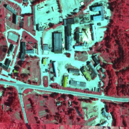
Das CIR-Dataset hat drei Bänder: Nah-Infrarot, Rot und Grün.
In Lettland werden Orthophotokarten im lettischen Koordinatensystem LKS-92 TM gemäß der TKS-93-Kartenblattunterteilung erstellt (ein Kartenblatt im Maßstab 1:10000 entspricht 5 × 5 Kilometern in der Natur). Orthophotokarten werden für das gesamte Gebiet Lettlands im Maßstab 1:10000 erstellt, aber für separate …
[[["Leicht verständlich","easyToUnderstand","thumb-up"],["Mein Problem wurde gelöst","solvedMyProblem","thumb-up"],["Sonstiges","otherUp","thumb-up"]],[["Benötigte Informationen nicht gefunden","missingTheInformationINeed","thumb-down"],["Zu umständlich/zu viele Schritte","tooComplicatedTooManySteps","thumb-down"],["Nicht mehr aktuell","outOfDate","thumb-down"],["Problem mit der Übersetzung","translationIssue","thumb-down"],["Problem mit Beispielen/Code","samplesCodeIssue","thumb-down"],["Sonstiges","otherDown","thumb-down"]],[],[],["Orthophoto maps for Latvia, provided by the Latvian Geospatial Information Agency, are available from 2007 to 2018. The CIR dataset, accessible via Earth Engine using `ee.ImageCollection(\"Latvia/Maamet/orthos/cir\")`, includes Near-Infrared, Red, and Green bands, each with a pixel size of 0.2 meters and a value range of 0-255. Maps are primarily at 1:10000 scale, with larger scales for cities. Terms of use and documentation are available via provided links.\n"]]