Page Summary
-
This dataset provides monthly maps and statistics on the location and temporal distribution of surface water globally from 1984 to 2020.
-
The data was generated using Landsat 5, 7, and 8 imagery classified into water/non-water pixels.
-
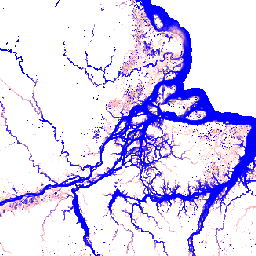
The Monthly Recurrence collection includes 12 images showing the seasonality of water based on its occurrence in each month over all years.
-
The dataset includes bands for monthly recurrence percentage and observation availability, with a pixel size of 30 meters.
-
This dataset is superseded by JRC/GSW1_4/MonthlyRecurrence.
- Dataset Availability
- 1984-03-16T00:00:00Z–2021-01-01T00:00:00Z
- Dataset Producer
- EC JRC / Google
- Climatological Interval
- 1 Month
- Tags
Description
This dataset contains maps of the location and temporal distribution of surface water from 1984 to 2020 and provides statistics on the extent and change of those water surfaces. For more information see the associated journal article: High-resolution mapping of global surface water and its long-term changes (Nature, 2016) and the online Data Users Guide.
These data were generated using 4,453,989 scenes from Landsat 5, 7, and 8 acquired between 16 March 1984 and 31 December 2020. Each pixel was individually classified into water / non-water using an expert system and the results were collated into a monthly history for the entire time period and two epochs (1984-1999, 2000-2020) for change detection.
The Monthly Recurrence collection contains 12 images: monthly measures of the seasonality of water based on the occurrence values detected in that month over all years.
Bands
Bands
Pixel size: 30 meters (all bands)
| Name | Units | Min | Max | Pixel Size | Description | ||||||||||||||||||||||||||||||||||||||||||||||||||||||||||||||||||||||||||||||||||||||||||||||
|---|---|---|---|---|---|---|---|---|---|---|---|---|---|---|---|---|---|---|---|---|---|---|---|---|---|---|---|---|---|---|---|---|---|---|---|---|---|---|---|---|---|---|---|---|---|---|---|---|---|---|---|---|---|---|---|---|---|---|---|---|---|---|---|---|---|---|---|---|---|---|---|---|---|---|---|---|---|---|---|---|---|---|---|---|---|---|---|---|---|---|---|---|---|---|---|---|---|---|---|
monthly_recurrence |
% | 0 | 100 | 30 meters | The recurrence value expressed as a percentage for this month. |
||||||||||||||||||||||||||||||||||||||||||||||||||||||||||||||||||||||||||||||||||||||||||||||
has_observations |
30 meters | A flag to indicate if the month has observations. |
|||||||||||||||||||||||||||||||||||||||||||||||||||||||||||||||||||||||||||||||||||||||||||||||||
Image Properties
Image Properties
| Name | Type | Description |
|---|---|---|
| month | DOUBLE | Month |
Terms of Use
Terms of Use
All data here is produced under the Copernicus Programme and is provided free of charge, without restriction of use. For the full license information see the Copernicus Regulation.
Publications, models, and data products that make use of these datasets must include proper acknowledgement, including citing datasets and the journal article as in the following citation.
If you are using the data as a layer in a published map, please include the following attribution text: 'Source: EC JRC/Google'
Citations
Jean-Francois Pekel, Andrew Cottam, Noel Gorelick, Alan S. Belward, High-resolution mapping of global surface water and its long-term changes. Nature 540, 418-422 (2016). (doi:10.1038/nature20584)
Explore with Earth Engine
Code Editor (JavaScript)
var dataset = ee.ImageCollection('JRC/GSW1_3/MonthlyRecurrence');

var visualization = {
  bands: ['monthly_recurrence'],
  min: 0.0,
  max: 100.0,
  palette: ['ffffff', 'ffbbbb', '0000ff']
};

Map.setCenter(-51.482, -0.835, 6);

Map.addLayer(dataset, visualization, 'Monthly Recurrence');