Page Summary
-
This dataset, which is now superseded by JRC/GSW1_4/MonthlyHistory, provides monthly maps and statistics of global surface water distribution and change from 1984 to 2015, generated from Landsat imagery.
-
The dataset includes 380 images, one for each month between March 1984 and October 2015, classifying each pixel as water, not water, or no data.
-
Data from this dataset is available free of charge under the Copernicus Programme, requiring proper acknowledgement and citation for use in publications, models, and data products.
- Dataset Availability
- 1984-03-16T00:00:00Z–2015-10-18T00:00:00Z
- Dataset Producer
- EC JRC / Google
- Cadence
- 1 Month
- Tags
Description
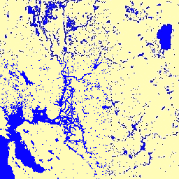
This dataset contains maps of the location and temporal distribution of surface water from 1984 to 2015 and provides statistics on the extent and change of those water surfaces. For more information see the associated journal article: High-resolution mapping of global surface water and its long-term changes (Nature, 2016) and the online Data Users Guide.
These data were generated using 3,066,102 scenes from Landsat 5, 7, and 8 acquired between 16 March 1984 and 10 October 2015. Each pixel was individually classified into water / non-water using an expert system and the results were collated into a monthly history for the entire time period and two epochs (1984-1999, 2000-2015) for change detection.
This Monthly History collection holds the entire history of water detection on a month-by-month basis. The collection contains 380 images, one for each month between March 1984 and October 2015.
Bands
Bands
Pixel size: 30 meters (all bands)
| Name | Pixel Size | Description | |||||||||||||||||||||||||||||||||||||||||||||||||||||||||||||||||||||||||||||||||||||||||||||||||
|---|---|---|---|---|---|---|---|---|---|---|---|---|---|---|---|---|---|---|---|---|---|---|---|---|---|---|---|---|---|---|---|---|---|---|---|---|---|---|---|---|---|---|---|---|---|---|---|---|---|---|---|---|---|---|---|---|---|---|---|---|---|---|---|---|---|---|---|---|---|---|---|---|---|---|---|---|---|---|---|---|---|---|---|---|---|---|---|---|---|---|---|---|---|---|---|---|---|---|---|
water |
30 meters | Water detection for the month. |
|||||||||||||||||||||||||||||||||||||||||||||||||||||||||||||||||||||||||||||||||||||||||||||||||
Image Properties
Image Properties
| Name | Type | Description |
|---|---|---|
| month | DOUBLE | Month |
| year | DOUBLE | Year |
Terms of Use
Terms of Use
All data here is produced under the Copernicus Programme and is provided free of charge, without restriction of use. For the full license information see the Copernicus Regulation.
Publications, models, and data products that make use of these datasets must include proper acknowledgement, including citing datasets and the journal article as in the following citation.
If you are using the data as a layer in a published map, please include the following attribution text: 'Source: EC JRC/Google'
Citations
Jean-Francois Pekel, Andrew Cottam, Noel Gorelick, Alan S. Belward, High-resolution mapping of global surface water and its long-term changes. Nature 540, 418-422 (2016). (doi:10.1038/nature20584)
Explore with Earth Engine
Code Editor (JavaScript)
var dataset = ee.ImageCollection('JRC/GSW1_0/MonthlyHistory')
                  .filter(ee.Filter.date('2015-01-01', '2015-12-31'));
var water = dataset.select('water');
var waterVis = {
  min: 0.0,
  max: 2.0,
  palette: ['ffffff', 'fffcb8', '0905ff'],
};
Map.setCenter(-58.999, -3.373, 7);
Map.addLayer(water, waterVis, 'Water');