- Ketersediaan Set Data
- 1975-01-01T00:00:00Z–2015-12-31T00:00:00Z
- Produsen Set Data
- EC JRC
- Tag
Deskripsi
GHSL mengandalkan desain dan penerapan teknologi penambangan data spasial baru yang memungkinkan pemrosesan dan ekstraksi analisis serta pengetahuan secara otomatis dari sejumlah besar data heterogen, termasuk: aliran data gambar satelit berskala halus global, data sensus, dan sumber informasi geografis yang dikumpulkan dari banyak orang atau sukarelawan.
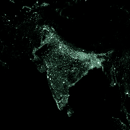
Set data ini menggambarkan distribusi dan kepadatan populasi, yang dinyatakan sebagai jumlah orang per sel, untuk era referensi: 1975, 1990, 2000, 2015.
Estimasi populasi penduduk disediakan oleh CIESIN GPW v4. Data ini didesagregasi dari unit sensus atau administrasi ke sel petak, yang didasarkan pada distribusi dan kepadatan kawasan terbangun seperti yang dipetakan dalam lapisan global GHSL per periode yang sesuai. (Lihat "Development of New Open and Free Multi-temporal Global Population Grids at 250 m Resolution".)
Set data ini dibuat dalam proyeksi World Mollweide (EPSG:54009).
Untuk mengetahui informasi selengkapnya, kunjungi: https://ghsl.jrc.ec.europa.eu/ghs_pop.php.
Project Global Human Settlement Layer (GHSL) didukung oleh European Commission, Joint Research Center, dan Directorate-General for Regional and Urban Policy. GHSL menghasilkan informasi spasial global baru, analisis berbasis bukti, dan pengetahuan yang menggambarkan kehadiran manusia di planet ini.
Band
Band
Ukuran piksel: 250 meter (semua band)
| Nama | Min | Maks | Ukuran Piksel | Deskripsi |
|---|---|---|---|---|
population_count |
0* | 1.34419e+06* | 250 meter | Jumlah orang per sel |
Persyaratan Penggunaan
Persyaratan Penggunaan
GHSL telah diproduksi oleh EC JRC sebagai data terbuka dan gratis. Penggunaan kembali diizinkan, asalkan sumbernya diakui. Untuk mengetahui informasi selengkapnya, baca persyaratan penggunaan (Pemberitahuan Penggunaan Ulang dan Hak Cipta Komisi Eropa).
Kutipan
European Commission, Joint Research Centre (JRC); Columbia University, Center for International Earth Science Information Network - CIESIN (2015): GHS population grid, yang berasal dari GPW4, multitemporal (1975, 1990, 2000, 2015). European Commission, Joint Research Centre (JRC) [Dataset] PID: https://data.europa.eu/89h/jrc-ghsl-ghs_pop_gpw4_globe_r2015a
Mengeksplorasi dengan Earth Engine
Editor Kode (JavaScript)
var dataset = ee.ImageCollection('JRC/GHSL/P2016/POP_GPW_GLOBE_V1')
                  .filter(ee.Filter.date('2015-01-01', '2015-12-31'));
var populationCount = dataset.select('population_count');
var populationCountVis = {
  min: 0.0,
  max: 200.0,
  palette: ['060606', '337663', '337663', 'ffffff'],
};
Map.setCenter(78.22, 22.59, 3);
Map.addLayer(populationCount, populationCountVis, 'Population Count');