The GHSL relies on the design and implementation of new spatial data mining
technologies allowing to automatically process and extract analytics and
knowledge from large amount of heterogeneous data including: global,
fine-scale satellite image data streams, census data, and crowd sources or
volunteered geographic information sources.
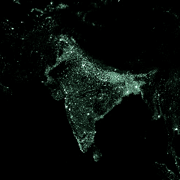
This dataset depicts the distribution and density of population, expressed
as the number of people per cell, for reference epochs: 1975, 1990, 2000,
2015.
The Global Human Settlement Layer (GHSL) project is supported by the
European Commission, Joint Research Center, and Directorate-General for
Regional and Urban Policy. The GHSL produces new global spatial information,
evidence-based analytics, and knowledge describing the human presence in
the planet.
Bands
Pixel Size 250 meters
Bands
Name
Min
Max
Pixel Size
Description
population_count
0*
1.34419e+06*
meters
Number of people per cell
* estimated min or max value
Terms of Use
Terms of Use
The GHSL has been produced by the EC JRC as open and free data. Reuse is
authorised, provided the source is acknowledged. For more information,
please read the use conditions (European Commission Reuse and Copyright
Notice).
Citations
Citations:
European Commission, Joint Research Centre (JRC); Columbia University,
Center for International Earth Science Information Network - CIESIN (2015):
GHS population grid, derived from GPW4, multitemporal (1975, 1990, 2000,
2015). European Commission, Joint Research Centre (JRC) [Dataset]
PID: https://data.europa.eu/89h/jrc-ghsl-ghs_pop_gpw4_globe_r2015a
The GHSL relies on the design and implementation of new spatial data mining technologies allowing to automatically process and extract analytics and knowledge from large amount of heterogeneous data including: global, fine-scale satellite image data streams, census data, and crowd sources or volunteered geographic information sources. This dataset depicts the …
[[["Easy to understand","easyToUnderstand","thumb-up"],["Solved my problem","solvedMyProblem","thumb-up"],["Other","otherUp","thumb-up"]],[["Missing the information I need","missingTheInformationINeed","thumb-down"],["Too complicated / too many steps","tooComplicatedTooManySteps","thumb-down"],["Out of date","outOfDate","thumb-down"],["Samples / code issue","samplesCodeIssue","thumb-down"],["Other","otherDown","thumb-down"]],[],[[["\u003cp\u003eThis dataset, now superseded by a newer version, provides global population distribution and density data from 1975 to 2015.\u003c/p\u003e\n"],["\u003cp\u003eIt uses CIESIN GPW v4 residential population estimates disaggregated to a 250-meter grid based on built-up areas.\u003c/p\u003e\n"],["\u003cp\u003ePopulation counts are provided as the number of people per grid cell, and the dataset is openly available for reuse with attribution.\u003c/p\u003e\n"],["\u003cp\u003eThe dataset was created by the Global Human Settlement Layer (GHSL) project, supported by the European Commission.\u003c/p\u003e\n"],["\u003cp\u003eUsers should consider using the newer dataset, JRC/GHSL/P2023A/GHS_POP, for updated and more comprehensive population information.\u003c/p\u003e\n"]]],["This dataset, now superseded, provides population distribution and density data from 1975, 1990, 2000, and 2015. It estimates the number of people per cell using census data disaggregated to 250-meter grid cells, informed by built-up area density. Data was produced using spatial data mining technologies. The data can be accessed via Earth Engine using the provided code snippet, selecting the `population_count` band. The dataset is free to use, with proper citation.\n"],null,["**Caution:** This dataset has been superseded by [JRC/GHSL/P2023A/GHS_POP](/earth-engine/datasets/catalog/JRC_GHSL_P2023A_GHS_POP). \n\nDataset Availability\n: 1975-01-01T00:00:00Z--2015-12-31T00:00:00Z\n\nDataset Provider\n:\n\n\n [EC JRC](https://ghsl.jrc.ec.europa.eu/index.php)\n\nTags\n:\n ciesin-derived \n ghsl \n jrc \npopulation \n\nDescription \nThe GHSL relies on the design and implementation of new spatial data mining\ntechnologies allowing to automatically process and extract analytics and\nknowledge from large amount of heterogeneous data including: global,\nfine-scale satellite image data streams, census data, and crowd sources or\nvolunteered geographic information sources.\n\nThis dataset depicts the distribution and density of population, expressed\nas the number of people per cell, for reference epochs: 1975, 1990, 2000,\n2015.\n\nResidential population estimates were provided by CIESIN GPW v4. These were\ndisaggregated from census or administrative units to grid cells, informed by\nthe distribution and density of built-up as mapped in the GHSL global layer\nper corresponding epoch. (See [\"Development of New Open and Free\nMulti-temporal Global Population Grids at 250 m\nResolution.\"](https://publications.jrc.ec.europa.eu/repository/handle/JRC100523))\n\nThis dataset was produced in the World Mollweide projection (EPSG:54009).\n\nFor more information visit: \u003chttps://ghsl.jrc.ec.europa.eu/ghs_pop.php\u003e.\n\nThe Global Human Settlement Layer (GHSL) project is supported by the\nEuropean Commission, Joint Research Center, and Directorate-General for\nRegional and Urban Policy. The GHSL produces new global spatial information,\nevidence-based analytics, and knowledge describing the human presence in\nthe planet.\n\nBands\n\n\n**Pixel Size**\n\n250 meters\n\n**Bands**\n\n| Name | Min | Max | Pixel Size | Description |\n|--------------------|-----|---------------|------------|---------------------------|\n| `population_count` | 0\\* | 1.34419e+06\\* | meters | Number of people per cell |\n\n\\* estimated min or max value\n\nTerms of Use\n\n**Terms of Use**\n\nThe GHSL has been produced by the EC JRC as open and free data. Reuse is\nauthorised, provided the source is acknowledged. For more information,\nplease read the use conditions ([European Commission Reuse and Copyright\nNotice](https://ec.europa.eu/info/legal-notice_en)).\n\nCitations \nCitations:\n\n- European Commission, Joint Research Centre (JRC); Columbia University,\n Center for International Earth Science Information Network - CIESIN (2015):\n GHS population grid, derived from GPW4, multitemporal (1975, 1990, 2000,\n 2015). European Commission, Joint Research Centre (JRC) \\[Dataset\\]\n PID: \u003chttps://data.europa.eu/89h/jrc-ghsl-ghs_pop_gpw4_globe_r2015a\u003e\n\nExplore with Earth Engine **Important:** Earth Engine is a platform for petabyte-scale scientific analysis and visualization of geospatial datasets, both for public benefit and for business and government users. Earth Engine is free to use for research, education, and nonprofit use. To get started, please [register for Earth Engine access.](https://console.cloud.google.com/earth-engine)\n\nCode Editor (JavaScript) \n\n```javascript\nvar dataset = ee.ImageCollection('JRC/GHSL/P2016/POP_GPW_GLOBE_V1')\n .filter(ee.Filter.date('2015-01-01', '2015-12-31'));\nvar populationCount = dataset.select('population_count');\nvar populationCountVis = {\n min: 0.0,\n max: 200.0,\n palette: ['060606', '337663', '337663', 'ffffff'],\n};\nMap.setCenter(78.22, 22.59, 3);\nMap.addLayer(populationCount, populationCountVis, 'Population Count');\n```\n[Open in Code Editor](https://code.earthengine.google.com/?scriptPath=Examples:Datasets/JRC/JRC_GHSL_P2016_POP_GPW_GLOBE_V1) \n[GHSL: Global Human Settlement Layers, Population Grid 1975-1990-2000-2015 (P2016) \\[deprecated\\]](/earth-engine/datasets/catalog/JRC_GHSL_P2016_POP_GPW_GLOBE_V1) \nThe GHSL relies on the design and implementation of new spatial data mining technologies allowing to automatically process and extract analytics and knowledge from large amount of heterogeneous data including: global, fine-scale satellite image data streams, census data, and crowd sources or volunteered geographic information sources. This dataset depicts the ... \nJRC/GHSL/P2016/POP_GPW_GLOBE_V1, ghsl,jrc,population \n1975-01-01T00:00:00Z/2015-12-31T00:00:00Z \n-90 -180 90 180 \nGoogle Earth Engine \nhttps://developers.google.com/earth-engine/datasets\n\n- [](https://doi.org/https://ghsl.jrc.ec.europa.eu/index.php)\n- [](https://doi.org/https://developers.google.com/earth-engine/datasets/catalog/JRC_GHSL_P2016_POP_GPW_GLOBE_V1)"]]