Page Summary
-
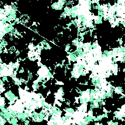
This dataset provides multitemporal information on built-up presence derived from Landsat imagery for the years 1975, 1990, 2000, and 2014.
-
The dataset is part of the Global Human Settlement Layer (GHSL) project, supported by the European Commission Joint Research Center.
-
It includes bands for built-up presence, confidence in the built-up class, and data availability masks for different epochs.
-
The GHSL dataset is open and free to use, with reuse authorized provided the source is acknowledged.
- Dataset Availability
- 1975-01-01T00:00:00Z–2014-12-31T00:00:00Z
- Dataset Producer
- EC JRC
- Tags
Description
The GHSL relies on the design and implementation of new spatial data mining technologies allowing to automatically process and extract analytics and knowledge from large amount of heterogeneous data including: global, fine-scale satellite image data streams, census data, and crowd sources or volunteered geographic information sources.
These data contain a multitemporal information layer on built-up presence as derived from Landsat image collections (GLS1975, GLS1990, GLS2000, and ad-hoc Landsat 8 collection 2013/2014).
The data have been produced by means of Global Human Settlement Layer methodology in 2015.
For more information visit: https://ghsl.jrc.ec.europa.eu/ghs_bu.php and https://ghsl.jrc.ec.europa.eu/documents/GHSL_data_access.pdf.
The Global Human Settlement Layer (GHSL) project is supported by the European Commission, Joint Research Center, and Directorate-General for Regional and Urban Policy. The GHSL produces new global spatial information, evidence-based analytics, and knowledge describing the human presence in the planet.
Bands
Bands
Pixel size: 38 meters (all bands)
| Name | Min | Max | Pixel Size | Description |
|---|---|---|---|---|
built |
38 meters | Multitemporal built-up presence |
||
cnfd |
0 | 255 | 38 meters | Gaps-filled confidence grid on the built-up class aggregated for 2014. 0 = 100% confidence of no built-up, 127 = 50% decision cut off, 255 = 100% conficence of yes built-up |
dm |
38 meters | Mosaic of data availability in the different epochs. |
built Class Table
| Value | Color | Description |
|---|---|---|
| 1 | #0c1d60 | Water surface |
| 2 | #000000 | Land no built-up in any epoch |
| 3 | #448564 | Built-up from 2000 to 2014 epochs |
| 4 | #70daa4 | Built-up from 1990 to 2000 epochs |
| 5 | #83ffbf | Built-up from 1975 to 1990 epochs |
| 6 | #ffffff | built-up up to 1975 epoch |
dm Class Table
| Value | Color | Description |
|---|---|---|
| 1 | None | No data availability for any epoch |
| 2 | None | 1975 |
| 3 | None | 1990 |
| 4 | None | 1975 and 1990 |
| 5 | None | 2000 |
| 6 | None | 1975 and 2000 |
| 7 | None | 1990 and 2000 |
| 8 | None | 1975, 1990, and 2000 |
| 9 | None | 2015 |
| 10 | None | 1975 and 2015 |
| 11 | None | 1990 and 2015 |
| 12 | None | 1975, 1990, and 2015 |
| 13 | None | 2000 and 2015 |
| 14 | None | 1975, 2000, and 2015 |
| 15 | None | 1990, 2000. and 2015 |
| 16 | None | 1995, 1190, 2000, and 2015 |
Terms of Use
Terms of Use
The GHSL has been produced by the EC JRC as open and free data. Reuse is authorised, provided the source is acknowledged. For more information, please read the use conditions (European Commission Reuse and Copyright Notice).
Citations
Pesaresi, Martino; Ehrilch, Daniele; Florczyk, Aneta J.; Freire, Sergio; Julea, Andreea; Kemper, Thomas; Soille, Pierre; Syrris, Vasileios (2015): GHS built-up grid, derived from Landsat, multitemporal (1975, 1990, 2000, 2014). European Commission, Joint Research Centre (JRC) [Dataset] PID: https://data.europa.eu/89h/jrc-ghsl-ghs_built_ldsmt_globe_r2015b
Pesaresi, Martino; Ehrlich, Daniele; Florczyk, Aneta J.; Freire, Sergio; Julea, Andreea; Kemper, Thomas; Soille, Pierre; Syrris, Vasileios (2015): GHS built-up confidence grid, derived from Landsat, multitemporal (1975, 1990, 2000, 2014). European Commission, Joint Research Centre (JRC) [Dataset] PID: https://data.europa.eu/89h/jrc-ghsl-ghs_built_ldsmtcnfd_globe_r2015b
Pesaresi, Martino; Ehrlich, Daniele; Florczyk, Aneta J.; Freire, Sergio; Julea, Andreea; Kemper, Thomas; Soille, Pierre; Syrris, Vasileios (2015): GHS built-up datamask grid derived from Landsat, multitemporal (1975, 1990, 2000, 2014). European Commission, Joint Research Centre (JRC) [Dataset] PID: https://data.europa.eu/89h/jrc-ghsl-ghs_built_ldsmtdm_globe_r2015b
Explore with Earth Engine
Code Editor (JavaScript)
var dataset = ee.Image('JRC/GHSL/P2016/BUILT_LDSMT_GLOBE_V1');
var builtUpMultitemporal = dataset.select('built');
var visParams = {
  min: 1.0,
  max: 6.0,
  palette: ['0c1d60', '000000', '448564', '70daa4', '83ffbf', 'ffffff'],
};
Map.setCenter(8.9957, 45.5718, 12);
Map.addLayer(builtUpMultitemporal, visParams, 'Built-Up Multitemporal');