- Dataset Availability
- 2020-12-31T00:00:00Z–2020-12-31T00:00:01Z
- Dataset Producer
- Joint Research Centre, European Commission
- Tags
Description
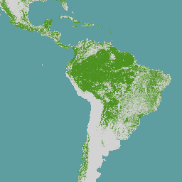
The global map of forest cover provides a spatially explicit representation of forest presence and absence for the year 2020 at 10m spatial resolution.
The year 2020 corresponds to the cut-off date of the Regulation from the European Union "on the making available on the Union market and the export from the Union of certain commodities and products associated with deforestation and forest degradation" (EUDR, Regulation (EU) 2023/1115). In the context of the EUDR, the global forest cover map can be used as a non-mandatory, non-exclusive and not legally binding source of information. Further information about the map and its use can be found on the EU Observatory on Deforestation and Forest Degradation (EUFO) and namely in the section on Frequently Asked Questions.
Forest means land spanning more than 0.5 hectares with trees higher than 5 meters and a canopy cover of more than 10%, or trees able to reach those thresholds in situ, excluding land that is predominantly under agricultural or urban land use. Agricultural use means the use of land for the purpose of agriculture, including for agricultural plantations (i.e. tree stands in agricultural production systems such as fruit tree plantations, oil palm plantations, olive orchards and agroforestry systems) and set- aside agricultural areas, and for rearing livestock. All plantations of relevant commodities other than wood, that is cattle, cocoa, coffee, oil palm, rubber, soya are excluded from the forest definition.
In a first step, the workflow identifies the maximum potential extent of forest cover circa 2020 by integrating global tree- and mangrove cover data for the year 2020 (e.g. Copernicus global land cover map). In addition, this delineation uses historical time-series of tree cover and loss to identify areas of potentially unstocked forest due to e.g., natural disturbances or forest management practices. In a second step, this maximum potential forest extent is intersected with various other data layers on tree height, deforestation, cropland, agroforestry, and other land uses. The application of a series of complex Boolean decision rules excludes areas that are not forest according to the definition of the FAO-FRA and EUDR.
The global input layers, mapping approach, and accuracy of GFC 2020 version 3 are described in a Science for Policy report released in May 2026 and available from the JRC Publications Repository: Bourgoin et al. 2026. A technical report (Bourgoin et al. 2024) describes the mapping approach for the first version; methodological changes in version 2 and comparisons with other maps are described in Bourgoin et al. (2025). Colditz et al. (2025) describe the accuracy assessment protocol and results for GFC 2020 version 2. Bourgoin et al. 2025 present the mapping methodology and accuracy and compare the map to other global products. A comparative study between GFC 2020 version 1 and a national map was carried out over Ivory Coast (Verhegghen et al, 2024). A user guide explains how to visualize and interact with GFC2020 to support the EUDR risk assessment (Simonetti et al. 2025).
The GFC 2020 map may be revised if new information, additional large-scale data layers or revised global spatial data layers for year 2020 will be made available.
For a list of known issues please refer to this website.
Bands
Bands
Pixel size: 10 meters (all bands)
| Name | Pixel Size | Description |
|---|---|---|
Map |
10 meters | Global forest cover 2020 |
Map Class Table
| Value | Color | Description |
|---|---|---|
| 1 | #4d9221 | Forest |
Terms of Use
Terms of Use
The data may be used by anyone, anywhere, anytime without permission, license or royalty payment. Attribution using the recommended citation is requested.
Citations
Bourgoin, Clement; Verhegghen, Astrid; Ameztoy, Iban; Carboni, Silvia; Achard, Frederic; Colditz, Rene (2024): Global map of forest cover 2020 - version 3. European Commission, Joint Research PID: http://data.europa.eu/89h/8c561543-31df-4e1b-9994-e529afecaf54
Bourgoin, C., Verhegghen, A., Carboni, S., Ameztoy, I., Degreve, L., Fritz, S., Herold, M., Tsendbazar, N., Lesiv, M., Achard, F., and Colditz, R.: GFC2020: A Global Map of Forest Land Use for year 2020 to Support the EU Deforestation Regulation, Earth Syst. Sci. Data Discuss. https://doi.org/10.5194/essd-2025-351, 2025.
Bourgoin, C., Verhegghen, A., Ameztoy, I., Beuchle, R., Carboni, S. et al., Maps of Global Forest Cover 2020 Version 3 and Global Forest Type 2020 Version 1 Supporting the EU Deforestation Regulation - Methodology, Accuracy Assessment and Comparison, Publications Office of the European Union, Luxembourg, 2026, https://data.europa.eu/doi/10.2760/9982436, JRC146622.
Explore with Earth Engine
Code Editor (JavaScript)
var image2020 = ee.Image('JRC/GFC2020/V3');

var visualization = {
  bands: ['Map'],
  palette: ['4D9221']};

Map.setCenter(0.0, 0.0, 2);

Map.addLayer(image2020, visualization, 'EC JRC Global forest cover 2020 – V3');