Page Summary
-
This dataset, the EC JRC global map of forest cover version 1, has been superseded by JRC/GFC2020/V2.
-
The dataset provides a global map of forest presence and absence for the year 2020 at 10m spatial resolution.
-
The 2020 data aligns with the cut-off date of the EU regulation on deforestation-free supply chains (EUDR), serving as a non-mandatory information source.
-
The definition of "forest" used in this dataset excludes land predominantly under agricultural or urban land use, including specific agricultural plantations.
-
The map was created by combining various global datasets on tree cover, tree height, land cover, and land use, applying overlays and decision rules to align with the forest definition.
- Dataset Availability
- 2020-12-31T00:00:00Z–2020-12-31T00:00:01Z
- Dataset Producer
- Joint Research Centre, European Commission
- Cadence
- 1 Year
- Tags
Description
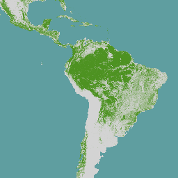
The EC JRC global map of forest cover provides a spatially explicit representation of forest presence and absence for the year 2020 at 10m spatial resolution.
The year 2020 corresponds to the cut-off date of the Regulation from the European Union "on the making available on the Union market and the export from the Union of certain commodities and products associated with deforestation and forest degradation" (EUDR, Regulation (EU) 2023/1115). In the context of the EUDR, the global forest cover map can be used as a non-mandatory, non-exclusive, and not legally binding source of information. Further information about the map and its use can be found on the EU Observatory on Deforestation and Forest Degradation (EUFO) in the section on Frequently Asked Questions.
Forest means land spanning more than 0.5 hectares with trees higher than 5 meters and a canopy cover of more than 10%, or trees able to reach those thresholds in situ, excluding land that is predominantly under agricultural or urban land use. Agricultural use means the use of land for the purpose of agriculture, including for agricultural plantations (i.e. tree stands in agricultural production systems such as fruit tree plantations, oil palm plantations, olive orchards and agroforestry systems) and set- aside agricultural areas, and for rearing livestock. All plantations of relevant commodities other than wood, that is cattle, cocoa, coffee, oil palm, rubber, soya, are excluded from the forest definition.
The global map of forest cover was created by combining available global datasets (wall-to-wall or global in their scope) on tree cover, tree height, land cover and land use into a single harmonized globally-consistent representation of where forests existed in 2020.
The workflow consisted in first mapping the global maximum extent of tree cover circa the year 2020 from the combination of ESA World Cover 2020 and 2021, WRI Tropical Tree Cover 2020, UMD Global land cover and land use 2019, Global Mangrove Watch 2020, and JRC Tropical Moist Forest 2020 datasets. In the second step, a series of overlays and decision rules were applied to reduce this maximum extent of tree cover and align it with the Forest definition using datasets covering cropland and commodity expansion (ESA World Cereal, UMD Global land cover and land use 2019, UMD Global Cropland Expansion, High-resolution global map of smallholder and industrial oil palm plantations, and WRI Spatial Database of Planted Trees), land use change (UMD global forest cover loss, JRC Tropical Moist Forest, IIASA Global Forest Management), built-up (JRC Global Human Settlement), and water (JRC Global Surface Water).
The global input layers, mapping approach, and a preliminary accuracy assessment are described in a JRC science for policy report. The JRC will undertake a formal statistically and thematically robust accuracy assessment in 2024.
Please also refer to the list of known issues and to the JRC Data Catalogue entry.
Bands
Bands
Pixel size: 10 meters (all bands)
| Name | Pixel Size | Description |
|---|---|---|
Map |
10 meters | Global forest cover 2020 |
Map Class Table
| Value | Color | Description |
|---|---|---|
| 1 | #4d9221 | Forest |
Terms of Use
Terms of Use
The data may be used by anyone, anywhere, anytime without permission, license or royalty payment. Attribution using the recommended citation is requested.
Citations
Bourgoin, Clement; Ameztoy, Iban; Verhegghen, Astrid; Carboni, Silvia; Colditz, Rene R.; Achard, Frederic (2023): Global map of forest cover 2020 - version 1. European Commission, Joint Research Centre (JRC) [Dataset] PID: http://data.europa.eu/89h/10d1b337-b7d1-4938-a048-686c8185b290.
Bourgoin, C., Ameztoy, I., Verhegghen, A., Desclée, B., Carboni, S., Bastin, J., Beuchle, R., Brink, A., Defourny, P., Delhez, B., Fritz, S., Gond, V., Herold, M., Lamarche, C., Mansuy, N., Mollicone, D., Oom, D., Peedell, S., San-Miguel, J., Colditz, R. and Achard, F., Mapping Global Forest Cover of the Year 2020 to Support the EU Regulation on Deforestation-free Supply Chains, Publications Office of the European Union, Luxembourg, 2024, doi:10.2760/262532, JRC136960.
DOIs
Explore with Earth Engine
Code Editor (JavaScript)
var image2020 = ee.ImageCollection('JRC/GFC2020/V1').filterDate(
  '2020-12-31').first();

var visualization = {
  bands: ['Map'],
  palette: ['4D9221']};

Map.setCenter(0.0, 0.0, 2);

Map.addLayer(image2020, visualization, 'EC JRC Global forest cover 2020 – V1');