Page Summary
-
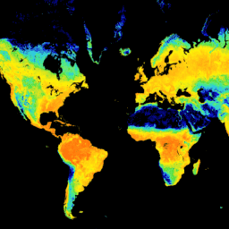
This dataset, provided by JAXA's Global Change Observation Mission (GCOM), measures the sum of one-sided green leaf area per unit ground area globally.
-
The data is available from November 29, 2021, to October 15, 2025, with a daily cadence and a latency of 3-4 days.
-
The dataset is free to use without restrictions, requiring credit to the Japan Aerospace Exploration Agency for any publications or value-added data products.
-
The GCOM-C mission and its SGLI sensor aim to provide long-term, continuous global observations for understanding climate mechanisms and improving environmental change predictions.
- Dataset Availability
- 2021-11-29T00:00:00Z–2026-07-15T00:00:00Z
- Dataset Producer
- Global Change Observation Mission (GCOM)
- Cadence
- 1 Day
- Tags
Description
This product is the sum of the one-sided green leaf area per unit ground area.
This is an ongoing dataset with a latency of 3-4 days.
GCOM-C conducts long-term and continuous global observation and data collection to elucidate the mechanism behind fluctuations in radiation budget and carbon cycle needed to make accurate projections regarding future temperature rise. At the same time, cooperating with research institutions having a climate numerical model, it contributes to reduction of errors in temperature rise prediction derived from the climate numerical model and improvement of accuracy of prediction of various environmental changes. SGLI mounted on GCOM-C is the succession sensor of the Global Imager (GLI) mounted on ADEOS-II (MIDORI II) and is the Imaging Radiometer which measures the radiation from near-ultraviolet to thermal infrared region (380 nm-12 um) in 19 channels. Global observation of once for approximately every two days is possible at mid-latitude near Japan by observation width at ground greater than 1,000 km. In addition, SGLI realizes high resolution than the similar global sensor and has a polarized observation function and a multi-angle observation function.
Bands
Bands
Pixel size: 4638.3 meters (all bands)
| Name | Min | Max | Pixel Size | Description | |||||||||||||||||||||||||||||||||||||||||||||||||||||||||||||||||||||||||||||||||||||||||||||||
|---|---|---|---|---|---|---|---|---|---|---|---|---|---|---|---|---|---|---|---|---|---|---|---|---|---|---|---|---|---|---|---|---|---|---|---|---|---|---|---|---|---|---|---|---|---|---|---|---|---|---|---|---|---|---|---|---|---|---|---|---|---|---|---|---|---|---|---|---|---|---|---|---|---|---|---|---|---|---|---|---|---|---|---|---|---|---|---|---|---|---|---|---|---|---|---|---|---|---|---|
LAI_AVE |
0* | 65531* | 4638.3 meters | The sum of the one-sided green leaf area per unit ground area. |
|||||||||||||||||||||||||||||||||||||||||||||||||||||||||||||||||||||||||||||||||||||||||||||||
LAI_QA_flag |
4638.3 meters | LAI QA |
|||||||||||||||||||||||||||||||||||||||||||||||||||||||||||||||||||||||||||||||||||||||||||||||||
Image Properties
Image Properties
| Name | Type | Description |
|---|---|---|
| ALGORITHM_VERSION | STRING | Algorithm version |
| GRID_INTERVAL | STRING | Spatial resolution |
| GRID_INTERVAL_UNIT | STRING | Unit of GRID_INTERVAL |
| IMAGE_END_TIME | STRING | Image acquisition end time |
| IMAGE_START_TIME | STRING | Image acquisition start time |
| PROCESSING_RESULT | STRING | Good, Fair, Poor, NG |
| PROCESSING_UT | STRING | Processing time |
| PRODUCT_FILENAME | STRING | Source filename |
| PRODUCT_VERSION | STRING | Product version |
| SATELLITE_DIRECTION | STRING | Satellite orbit direction
|
| LAI_AVE_OFFSET | STRING | Offset |
| LAI_AVE_SLOPE | STRING | Slope |
Terms of Use
Terms of Use
This dataset is free to use without any restrictions (including commercial use). Anyone wishing to publish analyzed results or value added data products should properly credit the original G-Portal data, e.g., "PR data by Japan Aerospace Exploration Agency". For value added data products, please indicate the credit of the original G-Portal data, e.g., "Original data for this value added data product was provided by Japan Aerospace Exploration Agency."
See G-Portal's terms of service (Article 7) for additional information.
Citations
Kobayashi, T., Ono, Y., Kobayashi, H., Yang, W. (June. 2020). GCOM-C/SGLI Leaf Area Index (LAI)/ fraction of Absorbed Photosynthetically Active Radiation (fAPAR) Product Algorithm Theoretical Basis Document (Version 2). Retrieved from https://suzaku.eorc.jaxa.jp/GCOM_C/data/ATBD/ver2/V2ATBD_T2B_LAI_Kobayashi_r1.pdf
Explore with Earth Engine
Code Editor (JavaScript)
var dataset = ee.ImageCollection('JAXA/GCOM-C/L3/LAND/LAI/V3')
                .filterDate('2021-12-01', '2022-01-01')
                // filter to daytime data only
                .filter(ee.Filter.eq('SATELLITE_DIRECTION', 'D'));

// Multiply with slope coefficient
var dataset = dataset.mean().multiply(0.001);

var visualization = {
  bands: ['LAI_AVE'],
  min: -7,
  max: 7,
  palette: [
    '040274','040281','0502a3','0502b8','0502ce','0502e6',
    '0602ff','235cb1','307ef3','269db1','30c8e2','32d3ef',
    '3be285','3ff38f','86e26f','3ae237','b5e22e','d6e21f',
    'fff705','ffd611','ffb613','ff8b13','ff6e08','ff500d',
    'ff0000','de0101','c21301','a71001','911003',
  ]
};

Map.setCenter(128.45, 33.33, 5);

Map.addLayer(dataset, visualization, 'Leaf Area Index');