- ความพร้อมใช้งานของชุดข้อมูล
- 2015-01-01T00:00:00Z–2024-01-01T00:00:00Z
- ผู้ผลิตชุดข้อมูล
- JAXA EORC
- แท็ก
คำอธิบาย
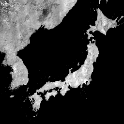
ภาพโมเสค PALSAR/PALSAR-2 ทั่วโลกขนาด 25 ม. คือภาพ SAR ทั่วโลกที่ไร้รอยต่อ ซึ่งสร้างขึ้นโดยการต่อแถบภาพ SAR จาก PALSAR/PALSAR-2 สำหรับแต่ละปีและแต่ละสถานที่ เราเลือกข้อมูลแถบผ่านการตรวจสอบด้วยสายตาของ ภาพโมเสกของการเรียกดูที่มีในช่วงระยะเวลาดังกล่าว โดยจะใช้ภาพที่แสดงการตอบสนองต่อความชื้นบนพื้นผิวต่ำสุดเป็นหลัก เราใช้เฉพาะข้อมูลจากปีเป้าหมายสำหรับภาพโมเสกรายปีแต่ละภาพ จึงไม่มีการเติมช่องว่างโดยใช้ข้อมูลจากปีก่อนหน้าในกรณีที่มีช่องว่าง ในการครอบคลุมทั่วโลกรายปี
ไม่มีข้อมูลสำหรับปี 2011-2014 เนื่องจากช่วงเวลาที่ ALOS และ ALOS-2 ครอบคลุมไม่ต่อเนื่องกัน
ภาพ SAR ได้รับการแก้ไขเชิงตั้งฉากและแก้ไขความลาดชันโดยใช้ แบบจำลองพื้นผิวเชิงเลข ALOS World 3D - 30m (AW3D30)
เราใช้กระบวนการลดแถบ (Shimada & Isoguchi, 2002, 2010) เพื่อปรับความแตกต่างของความเข้มระหว่างแถบที่อยู่ติดกัน ซึ่งส่วนใหญ่เกิดจากความแตกต่างตามฤดูกาลและรายวัน ในสภาพความชื้นของพื้นผิว
ข้อมูลโพลาไรเซชันจะจัดเก็บเป็นตัวเลขดิจิทัล (DN) ขนาด 16 บิต คุณแปลงค่า DN เป็นค่าแกมมาศูนย์ได้ ในหน่วยเดซิเบล (dB) โดยใช้สมการต่อไปนี้
- γ₀ = 10log₁₀(DN²) - 83.0 dB
ข้อควรระวัง:
- ค่า Backscatter อาจแตกต่างกันอย่างมากจากเส้นทางหนึ่งไปยังอีกเส้นทางหนึ่ง ในพื้นที่ป่าที่ละติจูดสูง เนื่องจากการเปลี่ยนแปลง ความเข้มของการกระเจิงย้อนกลับที่เกิดจากต้นไม้ที่แข็งตัวในฤดูหนาว
ดูข้อมูลเพิ่มเติมได้ในคำอธิบายชุดข้อมูลของผู้ให้บริการ
ย่านความถี่
ย่านความถี่
ขนาดพิกเซล: 25 เมตร (ทุกแถบ)
| ชื่อ | หน่วย | ขนาดพิกเซล | คำอธิบาย |
|---|---|---|---|
HH |
25 เมตร | สัมประสิทธิ์การกระเจิงกลับของโพลาไรเซชัน HH, DN 16 บิต |
|
HV |
25 เมตร | สัมประสิทธิ์การกระเจิงกลับของโพลาไรเซชัน HV, DN 16 บิต |
|
angle |
องศา | 25 เมตร | มุมตกกระทบในพื้นที่ |
epoch |
25 เมตร | การประทับเวลาของวันที่สังเกตการณ์ (มิลลิวินาทีนับตั้งแต่วันที่ 1 ม.ค. 1970) แถบนี้คำนวณแบบเรียลไทม์จากแถบ "วันที่" ของ ข้อมูลดิบ ซึ่งแสดงถึงความแตกต่างเป็นวันระหว่าง 2014-05-24 กับวันที่สังเกตการณ์ |
|
qa |
25 เมตร | การประมวลผลข้อมูล |
ตารางคลาส qa
| ค่า | สี | คำอธิบาย |
|---|---|---|
| 0 | #000000 | ไม่มีข้อมูล |
| 50 | #0000ff | มหาสมุทรและน้ำ |
| 100 | #aaaa00 | การซ้อนทับเรดาร์ |
| 150 | #005555 | การบดบังเรดาร์ |
| 255 | #aa9988 | ผืนดิน |
ข้อกำหนดในการใช้งาน
ข้อกำหนดในการใช้งาน
JAXA ยังคงเป็นเจ้าของชุดข้อมูลและไม่สามารถรับประกัน ปัญหาใดๆ ที่เกิดจากหรืออาจเกิดจากการใช้ชุดข้อมูล ผู้ที่ต้องการเผยแพร่ผลลัพธ์ใดๆ โดยใช้ชุดข้อมูลควร ระบุการเป็นเจ้าของข้อมูลในการเผยแพร่อย่างชัดเจน
การอ้างอิง
Masanobu Shimada, Takuya Itoh, Takeshi Motooka, Manabu Watanabe, Shiraishi Tomohiro, Rajesh Thapa และ Richard Lucas "New Global Forest/Non-forest Maps from ALOS PALSAR Data (2007-2010)" Remote Sensing of Environment, 155, pp. 13-31, December 2014 doi:10.1016/j.rse.2014.04.014
สำรวจด้วย Earth Engine
ตัวแก้ไขโค้ด (JavaScript)
var dataset = ee.ImageCollection('JAXA/ALOS/PALSAR/YEARLY/SAR_EPOCH')
                  .filter(ee.Filter.date('2017-01-01', '2018-01-01'));
var sarHh = dataset.select('HH');
var sarHhVis = {
  min: 0.0,
  max: 10000.0,
};
Map.setCenter(136.85, 37.37, 4);
Map.addLayer(sarHh, sarHhVis, 'SAR HH');