- ความพร้อมใช้งานของชุดข้อมูล
- 1900-01-01T00:00:00Z–2100-12-31T00:00:00Z
- ผู้ผลิตชุดข้อมูล
- University of California Merced
- ความถี่การบันทึก
- 1 วัน
- แท็ก
คำอธิบาย
ชุดข้อมูล MACAv2-METDATA คือคอลเล็กชันของแบบจำลองสภาพอากาศทั่วโลก 20 แบบที่ครอบคลุมสหรัฐอเมริกาที่อยู่ติดกัน วิธี Multivariate Adaptive Constructed Analogs (MACA) เป็นวิธีการลดขนาดทางสถิติ ซึ่งใช้ชุดข้อมูลการฝึก (เช่น ชุดข้อมูลการสังเกตทางอุตุนิยมวิทยา) เพื่อลบอคติในอดีตและจับคู่รูปแบบเชิงพื้นที่ในเอาต์พุตของโมเดลสภาพอากาศ
เราใช้วิธี MACA เพื่อลดขนาดเอาต์พุตของโมเดลจากโมเดลสภาพอากาศโลก (GCM) 20 รายการของโครงการเปรียบเทียบโมเดลแบบคู่ 5 (CMIP5) สำหรับการบังคับ GCM ในอดีต (1950-2005) และเส้นทางการกระจายก๊าซเรือนกระจก (RCP) ในอนาคต RCP 4.5 และ RCP 8.5 (2006-2100) จากความละเอียดดั้งเดิมของ GCM เป็น 4 กม.
ดูรายชื่อโมเดลทั้งหมดได้ที่ https://climate.northwestknowledge.net/MACA/GCMs.php
ย่านความถี่
ย่านความถี่
ขนาดพิกเซล: 4638.3 เมตร (ทุกแถบ)
| ชื่อ | หน่วย | ต่ำสุด | สูงสุด | ขนาดพิกเซล | คำอธิบาย |
|---|---|---|---|---|---|
tasmax |
K | 222.4* | 334.92* | 4638.3 เมตร | อุณหภูมิสูงสุดรายวันใกล้พื้นผิว |
tasmin |
K | 215.33* | 315.61* | 4638.3 เมตร | อุณหภูมิต่ำสุดรายวันใกล้พื้นผิว |
rhsmax |
% | 1* | 100* | 4638.3 เมตร | ความชื้นสัมพัทธ์รายวันสูงสุดใกล้พื้นผิว ซึ่งไม่มีในโมเดล CCSM4 หรือ NorESM1-M |
rhsmin |
% | 1* | 100* | 4638.3 เมตร | ความชื้นสัมพัทธ์รายวันขั้นต่ำใกล้พื้นผิว ไม่มีในโมเดล CCSM4 หรือ NorESM1-M |
huss |
เศษส่วนมวล | 0* | 0.05* | 4638.3 เมตร | ความชื้นสัมพัทธ์รายวันโดยเฉลี่ยใกล้พื้นผิว |
pr |
มม. | 0* | 1609.77* | 4638.3 เมตร | ปริมาณน้ำฝนเฉลี่ยรายวันที่พื้นผิว |
rsds |
W/m^2 | 9.06* | 455.61* | 4638.3 เมตร | รังสีคลื่นสั้นที่พื้นผิวโดยเฉลี่ยต่อวัน |
uas |
เมตร/วินาที | -29.74* | 25.96* | 4638.3 เมตร | องค์ประกอบลมพัดไปทางตะวันออกเฉลี่ยรายวันใกล้พื้นผิว |
vas |
เมตร/วินาที | -29.26* | 33.06* | 4638.3 เมตร | องค์ประกอบลมเฉลี่ยรายวันในทิศเหนือใกล้พื้นผิว |
พร็อพเพอร์ตี้รูปภาพ
พร็อพเพอร์ตี้รูปภาพ
| ชื่อ | ประเภท | คำอธิบาย |
|---|---|---|
| สถานการณ์ | STRING | ชื่อของสถานการณ์ CMIP5 ซึ่งเป็นหนึ่งใน "rcp85", "rcp45" หรือ "historical" |
| รุ่น | STRING | ชื่อโมเดล CMIP5 เช่น "inmcm4" |
| วงดนตรี | STRING | "r1i1p1" หรือ "r6i1p1" |
ข้อกำหนดในการใช้งาน
ข้อกำหนดในการใช้งาน
ชุดข้อมูล MACA สร้างขึ้นโดยได้รับเงินทุนจากรัฐบาลสหรัฐอเมริกาและเป็นสาธารณสมบัติในสหรัฐอเมริกา เพื่อความชัดเจนยิ่งขึ้น ชุดข้อมูล MACA มีให้ใช้งานภายใต้การอุทิศสากล CC0 1.0 ของ Creative Commons เว้นแต่จะระบุไว้เป็นอย่างอื่น กล่าวโดยสรุปคือ John Abatzoglou สละสิทธิ์ทั้งหมดในผลงานทั่วโลก ภายใต้กฎหมายลิขสิทธิ์ ซึ่งรวมถึงสิทธิที่เกี่ยวข้องและสิทธิข้างเคียงทั้งหมด ตามขอบเขตที่กฎหมายอนุญาต คุณสามารถคัดลอก ดัดแปลง แจกจ่าย และดำเนินการกับผลงานได้ แม้กระทั่งเพื่อวัตถุประสงค์เชิงพาณิชย์ โดยไม่ต้อง ขออนุญาต John Abatzoglou ไม่รับประกันเกี่ยวกับ ผลงาน และปฏิเสธความรับผิดสำหรับการใช้งานผลงานทั้งหมด ตามขอบเขตสูงสุดที่กฎหมายที่เกี่ยวข้องอนุญาต ผู้ใช้ควร อ้างอิงแหล่งที่มาที่ใช้ในการสร้างรายงานและสิ่งพิมพ์ ที่เกิดจากการใช้ชุดข้อมูลนี้อย่างถูกต้อง และจดบันทึกวันที่ที่ ได้ข้อมูล ดูข้อมูลเพิ่มเติมได้ที่หน้าข้อมูลอ้างอิงและใบอนุญาตของ MACA
การอ้างอิง
Abatzoglou J.T. and Brown T.J., A comparison of statistical downscaling methods suited for wildfire applications, International Journal of Climatology(2012) doi:10.1002/joc.2312.
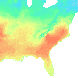
สำรวจด้วย Earth Engine
ตัวแก้ไขโค้ด (JavaScript)
var dataset = ee.ImageCollection('IDAHO_EPSCOR/MACAv2_METDATA')
                  .filter(ee.Filter.date('2018-08-01', '2018-08-15'));
var maximumTemperature = dataset.select('tasmax');
var maximumTemperatureVis = {
  min: 290.0,
  max: 314.0,
  palette: ['d8d8d8', '4addff', '5affa3', 'f2ff89', 'ff725c'],
};
Map.setCenter(-84.37, 33.5, 5);
Map.addLayer(maximumTemperature, maximumTemperatureVis, 'Maximum Temperature');