Page Summary
-
This dataset provides sea surface elevation data from the Hybrid Coordinate Ocean Model (HYCOM) and is available from 1992 to 2018 with daily updates.
-
The dataset includes interpolated salinity, temperature, velocity, and elevation variables on a 0.08 degree grid within a specific latitude range.
-
This deprecated dataset has been superseded by HYCOM/sea_surface_elevation.
-
The dataset is freely available with no restrictions.
- Dataset Availability
- 1992-10-02T00:00:00Z–2018-12-09T12:00:00Z
- Dataset Producer
- NOPP
- Cadence
- 1 Day
- Tags
Description
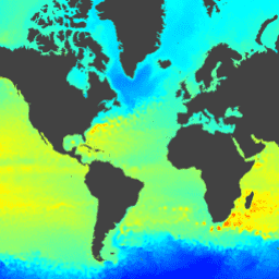
The Hybrid Coordinate Ocean Model (HYCOM) is a data-assimilative hybrid isopycnal-sigma-pressure (generalized) coordinate ocean model. The subset of HYCOM data hosted in EE contains the variables salinity, temperature, velocity, and elevation. They have been interpolated to a uniform 0.08 degree lat/long grid between 80.48°S and 80.48°N. The salinity, temperature, and velocity variables have been interpolated to 40 standard z-levels.
The HYCOM Consortium, which includes the National Ocean Partnership Program (NOPP), is part of the U.S. Global Ocean Data Assimilation Experiment (GODAE).
Funded by the National Ocean Partnership Program, the Office of Naval Research (ONR), and DoD High Performance Computing Modernization Program.
For more information, see:
- hycom.org
- GIS StackExchange hycom
- Wikipedia HyCOM
- Wikipedia List of ocean circulation models
- Wikipedia Ocean general circulation model (OGCM)
Bands
Bands
Pixel size: 8905.6 meters (all bands)
| Name | Units | Min | Max | Scale | Pixel Size | Description |
|---|---|---|---|---|---|---|
surface_elevation |
m | -5681* | 5965* | 0.001 | 8905.6 meters | Sea surface elevation anomaly relative to the modeled elevation mean |
Image Properties
Image Properties
| Name | Type | Description |
|---|---|---|
| experiment | STRING | Experiment number |
Terms of Use
Terms of Use
This dataset is freely available with no restrictions.
Citations
J. A. Cummings and O. M. Smedstad. 2013: Variational Data Assimilation for the Global Ocean. Data Assimilation for Atmospheric, Oceanic and Hydrologic Applications vol II, chapter 13, 303-343.
Explore with Earth Engine
Code Editor (JavaScript)
var dataset = ee.ImageCollection('HYCOM/GLBu0_08/sea_surface_elevation')
                  .filter(ee.Filter.date('2018-08-01', '2018-08-15'));
var surfaceElevation = dataset.select('surface_elevation');
var surfaceElevationVis = {
  min: -2000.0,
  max: 2000.0,
  palette: ['blue', 'cyan', 'yellow', 'red'],
};
Map.setCenter(-28.1, 28.3, 1);
Map.addLayer(surfaceElevation, surfaceElevationVis, 'Surface Elevation');