- Veri Kümesi Kullanılabilirliği
- 2021-04-30T00:00:00Z–2021-04-30T00:00:00Z
- Veri Kümesi Üreticisi
- Google Research - Open Buildings
- Etiketler
Açıklama
Bu büyük ölçekli açık veri kümesi, yüksek çözünürlüklü 50 cm uydu görüntülerinden elde edilen bina ana hatlarından oluşur. 19,4 milyon kilometrekarelik bir alanda (Afrika kıtasının% 64'ü) 516 milyon bina tespiti içerir.
Bu veri kümesindeki her bina için binanın temeldeki yerleşkesini tanımlayan polygonu, buranın bir bina olduğundan ne kadar emin olduğumuzu belirten güven puanını ve binanın merkezine karşılık gelen Plus Code'u dahil ediyoruz. Binanın türü, açık adresi veya geometrisi dışında herhangi bir ayrıntı hakkında bilgi yok.
Bina ayak izleri; nüfus tahmini, şehir planlaması ve insani yardım çalışmalarından çevre ve iklim bilimine kadar çeşitli önemli uygulamalarda faydalıdır. Proje Gana'da yürütüldüğünden şu anda Afrika kıtasına odaklanılmaktadır.
Çıkarım, Nisan 2021'de yapılmıştır.
Daha fazla bilgi için Open Buildings veri kümesinin resmi web sitesine bakın.
Bu verilerin güncellenmiş sürümlerinin bulunduğunu unutmayın. En yeni sürüm olan 3.0 sürümü (çıkarım Mayıs 2023'te yapılmıştır) GOOGLE/Research/open-buildings/v3/polygons olarak kullanılabilir.
Tablo Şeması
Tablo Şeması
| Ad | Tür | Açıklama |
|---|---|---|
| area_in_meters | ÇİFT | Çokgenin metrekare cinsinden alanı. |
| güvenilirlik | ÇİFT | Model tarafından atanan güven puanı [0.5;1.0]. |
| full_plus_code | Dize | Bina poligonunun ağırlık merkezindeki tam Plus Code. |
| longitude_latitude | GEOMETRY | Poligonun ağırlık merkezi. |
Kullanım Şartları
Kullanım Şartları
Alıntılar
W. Sirko, S. Kashubin, M. Ritter, A. Annkah, Y.S.E. Bouchareb, Y. Dauphin, D. Keysers, M. Neumann, M. Cisse, J.A. Quinn. Yüksek çözünürlüklü uydu görüntülerinden kıta ölçeğinde bina tespiti. arXiv:2107.12283, 2021.
Earth Engine ile Keşif
Kod Düzenleyici (JavaScript)
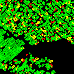
// Visualization of GOOGLE/Research/open-buildings/v1/polygons.

var t = ee.FeatureCollection('GOOGLE/Research/open-buildings/v1/polygons');

var t_060_065 = t.filter('confidence >= 0.60 && confidence < 0.65');
var t_065_070 = t.filter('confidence >= 0.65 && confidence < 0.70');
var t_gte_070 = t.filter('confidence >= 0.70');

Map.addLayer(t_060_065, {color: 'FF0000'}, 'Buildings confidence [0.60; 0.65)');
Map.addLayer(t_065_070, {color: 'FFFF00'}, 'Buildings confidence [0.65; 0.70)');
Map.addLayer(t_gte_070, {color: '00FF00'}, 'Buildings confidence >= 0.70');
Map.setCenter(3.389, 6.492, 17);  // Lagos, Nigeria
Map.setOptions('SATELLITE');
FeatureView olarak görselleştirme
FeatureView, FeatureCollection öğesinin salt görüntülemeye yönelik, hızlandırılmış bir gösterimidir. Daha fazla bilgi için
FeatureView dokümanlarını inceleyin.
Kod Düzenleyici (JavaScript)
var fvLayer = ui.Map.FeatureViewLayer(
  'GOOGLE/Research/open-buildings/v1/polygons_FeatureView');

var visParams = {
  rules: [
    {
      filter: ee.Filter.expression('confidence >= 0.60 && confidence < 0.65'),
      color: 'FF0000'
    },
    {
      filter: ee.Filter.expression('confidence >= 0.65 && confidence < 0.70'),
      color: 'FFFF00'
    },
    {
      filter: ee.Filter.expression('confidence >= 0.70'),
      color: '00FF00'
    },
  ]
};

fvLayer.setVisParams(visParams);
fvLayer.setName('Buildings');

Map.setCenter(3.389, 6.492, 17);  // Lagos, Nigeria
Map.add(fvLayer);
Map.setOptions('SATELLITE');