- Доступность набора данных
- 2000-01-01T00:00:00Z–2010-12-31T00:00:00Z
- Производитель наборов данных
- НАСА LP DAAC в Центре EROS Геологической службы США
- Каденция
- 5 лет
- Теги
- лес
Описание
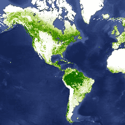
Слои данных о древесном покрове Landsat Vegetation Continuous Fields (VCF) содержат оценки процента горизонтальной поверхности земли в каждом 30-метровом пикселе, покрытой древесной растительностью высотой более 5 метров. Данные представляют три номинальных периода: 2000, 2005 и 2010 годы, и составлены на основе коллекции данных Landsat NASA/USGS Global Land Survey (GLS). Продукт получен из всех семи полос Landsat-5 Thematic Mapper (TM) и/или Landsat-7 Enhanced Thematic Mapper Plus (ETM+), в зависимости от выбора изображения GLS.
Древесный покров, пропорциональная, вертикально спроецированная площадь растительности (включая листья, стебли, ветви и т. д.) древесных растений над заданной высотой, влияет на наземный обмен энергией и водой, фотосинтез и транспирацию, чистую первичную продукцию, а также потоки углерода и питательных веществ. Древесный покров также влияет на качество среды обитания и перемещения диких животных, стоимость жилой недвижимости для людей и другие экосистемные услуги. Непрерывная схема классификации продукта VCF позволяет лучше отображать градиенты землепользования, чем традиционные дискретные схемы классификации. Что важно для обнаружения и мониторинга изменений лесов (например, вырубки и деградации), древесный покров предоставляет измеримый атрибут, на основе которого можно определять лесной покров и его изменения. Изменения древесного покрова во времени могут быть использованы для мониторинга и получения данных об истории изменений лесов на конкретных участках.
Набор данных был создан для трехлетних периодов: 2000, 2005, 2010, при этом в коллекции имеется изображение для каждого доступного пути/строки WRS2.
Группы
Группы
Размер пикселя: 30 метров (все диапазоны)
| Имя | Единицы | Мин | Макс | Размер пикселя | Описание |
|---|---|---|---|---|---|
tree_canopy_cover | % | 0 | 100 | 30 метров | Процент площади пикселей, покрытой деревьями. |
uncertainty | 30 метров | RMSE для показателя покрытия крон деревьев | |||
source_index | 30 метров | Идентификатор исходного изображения, использованного для конкретного пикселя. Это индекс в массиве метаданных «sources» для каждого изображения. |
Свойства изображения
Свойства изображения
| Имя | Тип | Описание |
|---|---|---|
| путь | ДВОЙНОЙ | Путь |
| полоса | НИТЬ | Тропа и ряд |
| ряд | ДВОЙНОЙ | Ряд |
| источники | ДВОЙНОЙ | Источники |
| палитра_классов_покрытия_кроны_дерева | ДВОЙНОЙ | Палитра цветов для класса покрытия кроны деревьев |
| значения_класса_покрытия_кроны_деревьев | ДВОЙНОЙ | Значения классов сомкнутости древесного полога |
| год | ДВОЙНОЙ | Год |
Условия эксплуатации
Условия эксплуатации
Права интеллектуальной собственности на этот набор данных принадлежат Университету штата Мэриленд, кафедре географических наук и НАСА. Использование разрешено бесплатно при условии указания источника.
Цитаты
Источник данных: Покрытие древесного полога, {Год, ...}, Глобальная система учета земельного покрова.
Цитирование статьи/методов: Sexton, JO, Song, X.-P., Feng, M., Noojipady, P., Anand, A., Huang, C., Kim, D.-H., Collins, KM, Channan, S., DiMiceli, C., Townshend, JRG (2013). Global, 30-m resolution continuous fields of tree cover: Landsat-based rescaleing of MODIS Vegetation Continuous Fields with lidar-based estimates of error. International Journal of Digital Earth, 130321031236007. doi:10.1080/17538947.2013.786146 .
DOI
Исследуйте мир с помощью Earth Engine.
Редактор кода (JavaScript)
var dataset = ee.ImageCollection('GLCF/GLS_TCC')
                  .filter(ee.Filter.date('2010-01-01', '2010-12-31'));
var treeCanopyCover = dataset.select('tree_canopy_cover');
var treeCanopyCoverVis = {
  min: 0.0,
  max: 100.0,
  palette: ['ffffff', 'afce56', '5f9c00', '0e6a00', '003800'],
};
Map.setCenter(-88.6, 26.4, 3);
Map.addLayer(treeCanopyCover, treeCanopyCoverVis, 'Tree Canopy Cover');