- Dataset Producer
- Copernicus Climate Data Store
- Tags
Description
ERA5-Land is a reanalysis dataset providing a consistent view of the evolution of land variables over several decades at an enhanced resolution compared to ERA5. ERA5-Land has been produced by replaying the land component of the ECMWF ERA5 climate reanalysis. Reanalysis combines model data with observations from across the world into a globally complete and consistent dataset using the laws of physics. Reanalysis produces data that goes several decades back in time, providing an accurate description of the climate of the past. This dataset includes all 50 variables as available on CDS.
ERA5-Land data is available from 1950 to three months from real-time.
Please consult the ERA5-Land "Known Issues" section. In particular, note that three components of the total evapotranspiration have values swapped as follows:
- variable "Evaporation from bare soil" (mars parameter code 228101 (evabs)) has the values corresponding to the "Evaporation from vegetation transpiration" (mars parameter 228103 (evavt)),
- variable "Evaporation from open water surfaces excluding oceans (mars parameter code 228102 (evaow)) has the values corresponding to the "Evaporation from bare soil" (mars parameter code 228101 (evabs)),
- variable "Evaporation from vegetation transpiration" (mars parameter code 228103 (evavt)) has the values corresponding to the "Evaporation from open water surfaces excluding oceans" (mars parameter code 228102 (evaow)).
This dataset contains the static variables of ERA5-Land. These variables do not vary in time.
Bands
Bands
Pixel size: 11132 meters (all bands)
| Name | Units | Pixel Size | Description |
|---|---|---|---|
glacier_mask |
Fraction | 11132 meters | Fraction of the grid box covered by ice (glacier or ice cap). The values vary between 0 and 1 but do not vary in time. |
lake_cover |
Fraction | 11132 meters | Fraction of the grid box that is occupied by lake (inland water). The values vary between 0 and 1 but do not vary in time. |
high_vegetation_cover |
Fraction | 11132 meters | Fraction of the grid box that is covered with vegetation that is classified as "high". The values vary between 0 and 1 but do not vary in time. "High vegetation" consists of evergreen trees, deciduous trees, mixed forest/woodland, and interrupted forest. |
low_vegetation_cover |
Fraction | 11132 meters | Fraction of the grid box that is covered with vegetation that is classified as "low". The values vary between 0 and 1 but do not vary in time. "Low vegetation" consists of crops and mixed farming, irrigated crops, short grass, tall grass, tundra, semidesert, bogs and marshes, evergreen shrubs, deciduous shrubs, and water and land mixtures. |
lake_total_depth |
m | 11132 meters | Total depth of the lake (both the water and ice part). This parameter does not vary in time. |
land_sea_mask |
Fraction | 11132 meters | Fraction of the grid box that is land. The values vary between 0 and 1 but do not vary in time. |
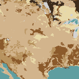
soil_type |
Dimensionless | 11132 meters | Texture (or classification) of soil used by the land surface scheme of the ECMWF Integrated Forecasting System (IFS) to predict the water holding capacity of soil in soil moisture and runoff calculations. It is derived from the root zone data (30-100 cm below the surface) of the FAO/UNESCO Digital Soil Map of the World, DSMW (FAO, 2003). |
type_of_high_vegetation |
Dimensionless | 11132 meters | Indicates the types of high vegetation recognised by the ECMWF Integrated Forecasting System. Vegetation types are used to calculate the surface energy balance and snow albedo. This parameter does not vary in time. |
type_of_low_vegetation |
Dimensionless | 11132 meters | Indicates the types of low vegetation recognised by the ECMWF Integrated Forecasting System. Vegetation types are used to calculate the surface energy balance and snow albedo. This parameter does not vary in time. |
soil_type Class Table
| Value | Color | Description |
|---|---|---|
| 0 | None | Non-land point |
| 1 | None | Coarse |
| 2 | None | Medium |
| 3 | None | Medium fine |
| 4 | None | Fine |
| 5 | None | Very fine |
| 6 | None | Organic |
| 7 | None | Tropical organic |
type_of_high_vegetation Class Table
| Value | Color | Description |
|---|---|---|
| 0 | None | None (including oceanic/inland water location) |
| 3 | None | Evergreen needleleaf trees |
| 4 | None | Deciduous needleleaf trees |
| 5 | None | Deciduous broadleaf trees |
| 6 | None | Evergreen broadleaf trees |
| 18 | None | Mixed forest/woodland |
| 19 | None | Interrupted forest |
type_of_low_vegetation Class Table
| Value | Color | Description |
|---|---|---|
| 0 | None | None (including oceanic/inland water location) |
| 1 | None | Crops, mixed farming |
| 2 | None | Grass |
| 7 | None | Tall grass |
| 9 | None | Tundra |
| 10 | None | Irrigated crops |
| 11 | None | Semidesert |
| 13 | None | Bogs and marshes |
| 16 | None | Evergreen shrubs |
| 17 | None | Deciduous shrubs |
| 20 | None | Water and land mixtures |
Terms of Use
Terms of Use
Please acknowledge the use of ERA5-Land as stated in the Copernicus C3S/CAMS License agreement:
5.1.1 Where the Licensee communicates or distributes Copernicus Products to the public, the Licensee shall inform the recipients of the source by using the following or any similar notice: 'Generated using Copernicus Climate Change Service Information [Year]'.
5.1.2 Where the Licensee makes or contributes to a publication or distribution containing adapted or modified Copernicus Products, the Licensee shall provide the following or any similar notice: 'Contains modified Copernicus Climate Change Service Information [Year]';
Any such publication or distribution covered by clauses 5.1.1 and 5.1.2 shall state that neither the European Commission nor ECMWF is responsible for any use that may be made of the Copernicus Information or Data it contains.
Citations
Muñoz Sabater, J., (2019): ERA5-Land monthly averaged data from 1981 to present. Copernicus Climate Change Service (C3S) Climate Data Store (CDS). (<date of access>), doi:10.24381/cds.68d2bb30
Explore with Earth Engine
Code Editor (JavaScript)
var dataset = ee.Image('ECMWF/ERA5_LAND/STATIC');

var soilType = dataset.select('soil_type').selfMask();

var visualization = {
  min: 1.0,
  max: 7.0,
  palette: [
    'e8d9a8', // 1 Coarse – pale sand
    'd2b48c', // 2 Medium – light tan
    'b8935f', // 3 Medium fine – warm brown
    '8b5a2b', // 4 Fine – medium brown
    '6b4423', // 5 Very fine – deep clay brown
    '3e2c1c', // 6 Organic – dark peat
    '26140b'  // 7 Tropical organic – near-black humus
  ]
};

Map.setCenter(22.2, 21.2, 2);

Map.addLayer(soilType, visualization, 'Soil type');