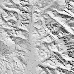
CHILI is a surrogate for effects of insolation and topographic shading on
evapotranspiration represented by calculating insolation at early afternoon,
sun altitude equivalent to equinox. It is based on the 30m SRTM DEM
(available in EE as USGS/SRTMGL1_003).
The Conservation Science Partners (CSP) Ecologically Relevant Geomorphology
(ERGo) Datasets, Landforms and Physiography contain detailed, multi-scale
data on landforms and physiographic (aka land facet) patterns. Although
there are many potential uses of these data, the original purpose for these
data was to develop an ecologically relevant classification and map of
landforms and physiographic classes that are suitable for climate adaptation
planning. Because there is large uncertainty associated with future climate
conditions and even more uncertainty around ecological responses, providing
information about what is unlikely to change offers a strong foundation for
managers to build robust climate adaptation plans. The quantification of
these features of the landscape is sensitive to the resolution, so we
provide the highest resolution possible given the extent and characteristics
of a given index.
Bands
Pixel Size 90 meters
Bands
Name
Min
Max
Pixel Size
Description
constant
0
255
meters
SRTM-derived CHILI index ranging from 0 (very cool) to 255
(very warm). This was rescaled from the [0,1] range in the publication.
Theobald, D. M., Harrison-Atlas, D., Monahan, W. B., & Albano, C. M.
(2015). Ecologically-relevant maps of landforms and physiographic diversity
for climate adaptation planning. PloS one, 10(12),
e0143619
CHILI is a surrogate for effects of insolation and topographic shading on evapotranspiration represented by calculating insolation at early afternoon, sun altitude equivalent to equinox. It is based on the 30m SRTM DEM (available in EE as USGS/SRTMGL1_003). The Conservation Science Partners (CSP) Ecologically Relevant Geomorphology (ERGo) Datasets, Landforms and …
[[["Easy to understand","easyToUnderstand","thumb-up"],["Solved my problem","solvedMyProblem","thumb-up"],["Other","otherUp","thumb-up"]],[["Missing the information I need","missingTheInformationINeed","thumb-down"],["Too complicated / too many steps","tooComplicatedTooManySteps","thumb-down"],["Out of date","outOfDate","thumb-down"],["Samples / code issue","samplesCodeIssue","thumb-down"],["Other","otherDown","thumb-down"]],[],[[["\u003cp\u003eThe SRTM CHILI dataset provides a global index of heat-insolation load, ranging from 0 (very cool) to 255 (very warm), derived from the SRTM DEM.\u003c/p\u003e\n"],["\u003cp\u003eThis dataset, developed by Conservation Science Partners, is intended for climate adaptation planning and ecological analysis.\u003c/p\u003e\n"],["\u003cp\u003eCHILI represents the effects of insolation and topographic shading on evapotranspiration, calculated at early afternoon sun altitude equivalent to equinox.\u003c/p\u003e\n"],["\u003cp\u003eIt is available at a 90-meter resolution and covers the period from January 24, 2006, to May 13, 2011.\u003c/p\u003e\n"],["\u003cp\u003eThe data is licensed under CC-BY-NC-SA-4.0.\u003c/p\u003e\n"]]],["The dataset, available from 2006-01-24 to 2011-05-13, provided by Conservation Science Partners, features the SRTM-derived CHILI index within the ERGo dataset. CHILI, a measure of insolation's impact on evapotranspiration, ranges from 0 (cool) to 255 (warm), based on a 30m SRTM DEM. Accessible via Earth Engine, it offers landform and physiographic data for climate adaptation planning. The pixel size is 90 meters and is offered under a CC-BY-NC-SA-4.0 license.\n"],null,["# Global SRTM CHILI (Continuous Heat-Insolation Load Index)\n\nDataset Availability\n: 2006-01-24T00:00:00Z--2011-05-13T00:00:00Z\n\nDataset Provider\n:\n\n\n [Conservation Science Partners](https://www.csp-inc.org/)\n\nTags\n:\n[aspect](/earth-engine/datasets/tags/aspect) [csp](/earth-engine/datasets/tags/csp) [elevation](/earth-engine/datasets/tags/elevation) [elevation-topography](/earth-engine/datasets/tags/elevation-topography) [ergo](/earth-engine/datasets/tags/ergo) [geophysical](/earth-engine/datasets/tags/geophysical) [global](/earth-engine/datasets/tags/global) [landforms](/earth-engine/datasets/tags/landforms) [slope](/earth-engine/datasets/tags/slope) [topography](/earth-engine/datasets/tags/topography) \n\n#### Description\n\nCHILI is a surrogate for effects of insolation and topographic shading on\nevapotranspiration represented by calculating insolation at early afternoon,\nsun altitude equivalent to equinox. It is based on the 30m SRTM DEM\n(available in EE as USGS/SRTMGL1_003).\n\nThe Conservation Science Partners (CSP) Ecologically Relevant Geomorphology\n(ERGo) Datasets, Landforms and Physiography contain detailed, multi-scale\ndata on landforms and physiographic (aka land facet) patterns. Although\nthere are many potential uses of these data, the original purpose for these\ndata was to develop an ecologically relevant classification and map of\nlandforms and physiographic classes that are suitable for climate adaptation\nplanning. Because there is large uncertainty associated with future climate\nconditions and even more uncertainty around ecological responses, providing\ninformation about what is unlikely to change offers a strong foundation for\nmanagers to build robust climate adaptation plans. The quantification of\nthese features of the landscape is sensitive to the resolution, so we\nprovide the highest resolution possible given the extent and characteristics\nof a given index.\n\n### Bands\n\n\n**Pixel Size**\n\n90 meters\n\n**Bands**\n\n| Name | Min | Max | Pixel Size | Description |\n|------------|-----|-----|------------|--------------------------------------------------------------------------------------------------------------------------------------|\n| `constant` | 0 | 255 | meters | SRTM-derived CHILI index ranging from 0 (very cool) to 255 (very warm). This was rescaled from the \\[0,1\\] range in the publication. |\n\n### Terms of Use\n\n**Terms of Use**\n\n[CC-BY-NC-SA-4.0](https://spdx.org/licenses/CC-BY-NC-SA-4.0.html)\n\n### Citations\n\nCitations:\n\n- Theobald, D. M., Harrison-Atlas, D., Monahan, W. B., \\& Albano, C. M.\n (2015). Ecologically-relevant maps of landforms and physiographic diversity\n for climate adaptation planning. PloS one, 10(12),\n [e0143619](https://journals.plos.org/plosone/article?id=10.1371/journal.pone.0143619)\n\n### Explore with Earth Engine\n\n| **Important:** Earth Engine is a platform for petabyte-scale scientific analysis and visualization of geospatial datasets, both for public benefit and for business and government users. Earth Engine is free to use for research, education, and nonprofit use. To get started, please [register for Earth Engine access.](https://console.cloud.google.com/earth-engine)\n\n### Code Editor (JavaScript)\n\n```javascript\nvar dataset = ee.Image('CSP/ERGo/1_0/Global/SRTM_CHILI');\nvar srtmChili = dataset.select('constant');\nvar srtmChiliVis = {\n min: 0.0,\n max: 255.0,\n};\nMap.setCenter(-105.8636, 40.3439, 11);\nMap.addLayer(srtmChili, srtmChiliVis, 'SRTM CHILI');\n```\n[Open in Code Editor](https://code.earthengine.google.com/?scriptPath=Examples:Datasets/CSP/CSP_ERGo_1_0_Global_SRTM_CHILI) \n[Global SRTM CHILI (Continuous Heat-Insolation Load Index)](/earth-engine/datasets/catalog/CSP_ERGo_1_0_Global_SRTM_CHILI) \nCHILI is a surrogate for effects of insolation and topographic shading on evapotranspiration represented by calculating insolation at early afternoon, sun altitude equivalent to equinox. It is based on the 30m SRTM DEM (available in EE as USGS/SRTMGL1_003). The Conservation Science Partners (CSP) Ecologically Relevant Geomorphology (ERGo) Datasets, Landforms and ... \nCSP/ERGo/1_0/Global/SRTM_CHILI, aspect,csp,elevation,elevation-topography,ergo,geophysical,global,landforms,slope,topography \n2006-01-24T00:00:00Z/2011-05-13T00:00:00Z \n-90 -180 90 180 \nGoogle Earth Engine \nhttps://developers.google.com/earth-engine/datasets\n\n- [](https://doi.org/https://www.csp-inc.org/)\n- [](https://doi.org/https://developers.google.com/earth-engine/datasets/catalog/CSP_ERGo_1_0_Global_SRTM_CHILI)"]]