- Verfügbarkeit des Datasets
- 2018-07-10T11:17:44Z–2026-07-22T09:09:34Z
- Ersteller des Datasets
- Europäische Union/ESA/Copernicus
- Wiederholungsintervall
- 2 Tage
- Tags
Beschreibung
NRTI/L3_AER_LH
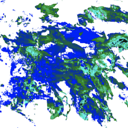
Dieses Dataset enthält hochauflösende Offlinebilder des UV-Aerosolindex (UVAI), auch Absorbing Layer Height (ALH) genannt.
Die ALH ist sehr anfällig für Wolkenkontamination. Aerosole und Wolken lassen sich jedoch nur schwer unterscheiden.Die ALH wird für alle effektiven Wolkenanteile von FRESCO berechnet, die kleiner als 0, 05 sind. Wolkenmasken sind von FRESCO und VIIRS verfügbar und werden dringend empfohlen, um nach Restwolken zu filtern. Außerdem ist eine Maske für Sonnenreflexionen verfügbar, um Regionen mit Sonnenreflexionen zu filtern, die nicht im Voraus gefiltert werden.
Es ist bekannt, dass hohe Oberflächenalbedos die ALH negativ beeinflussen und sie in Richtung der Oberfläche verschieben. Im Allgemeinen gilt die ALH über (dunklen) Ozeanen als zuverlässig und liegt innerhalb der Anforderung von 1.000 m oder 100 hPa. Über Land, insbesondere bei hellen Oberflächen, kann die Genauigkeit geringer sein. Die Verwendung des ALH-Produkts über hellen Oberflächen wie Wüsten wird nicht empfohlen.
Für dieses AER_LH-Produkt der Stufe 3 wird der mittlere Aerosoldruck anhand von Messungen bei den Wellenlängen 354 nm und 388 nm berechnet. Beim COPERNICUS/S5P/OFFL/L3_SO2 COPERNICUS/S5P/OFFL/L3_SO2 wird der Absorbing Aerosol Index anhand der Wellenlängen 340 nm und 380 nm berechnet.
Beispiel für den Aufruf von harpconvert für eine Kachel:
harpconvert --format hdf5 --hdf5-compression 9
-a 'aerosol_height_validity>50;derive(datetime_stop {time});
bin_spatial(2001, 50.000000, 0.01, 2001, -120.000000, 0.01);
keep(aerosol_height,aerosol_pressure,aerosol_optical_depth,
     sensor_zenith_angle,sensor_azimuth_angle,solar_azimuth_angle,solar_zenith_angle)'
S5P_NRTI_L2__AER_LH_20191202T233055_20191202T233555_11074_01_010302_20191203T012120.nc
output.h5
Sentinel-5 Precursor
Sentinel-5 Precursor ist ein Satellit, der am 13. Oktober 2017 von der Europäischen Weltraumorganisation ESA zur Überwachung der Luftverschmutzung gestartet wurde. Der Bordsensor wird häufig als Tropomi (TROPOspheric Monitoring Instrument) bezeichnet.
Alle S5P-Datasets außer CH4 sind in zwei Versionen verfügbar: Near Real-Time (NRTI) und Offline (OFFL). CH4 ist nur als OFFL verfügbar. Die NRTI-Assets decken eine kleinere Fläche als die OFFL-Assets ab, sind aber schneller verfügbar. Die OFFL-Assets enthalten Daten aus einem einzelnen Orbit. Da die Hälfte der Erde dunkel ist, enthalten sie nur Daten für eine Hemisphäre.
Aufgrund von Rauschen in den Daten werden häufig negative Werte für die vertikale Säule beobachtet, insbesondere in sauberen Regionen oder bei geringen SO2-Emissionen. Es wird empfohlen, diese Werte nicht zu filtern, außer bei Ausreißern, d. h. bei vertikalen Säulen mit einem Wert unter -0,001 mol/m^2.
Die ursprünglichen Sentinel 5P-Daten der Stufe 2 (L2) werden nach Zeit und nicht nach Breiten-/Längengrad gruppiert. Damit die Daten in Earth Engine aufgenommen werden können, wird jedes Sentinel 5P L2-Produkt in L3 konvertiert. Dabei wird ein einzelnes Raster pro Orbit beibehalten (d. h. es erfolgt keine Aggregation über Produkte hinweg).
Quellprodukte, die den Antimeridian umfassen, werden als zwei Earth Engine-Assets mit den Suffixen _1 und _2 aufgenommen.
Die Konvertierung in L3 erfolgt mit dem harpconvert
Tool und der bin_spatial Operation. Die Quelldaten werden gefiltert, um Pixel mit QA-Werten unter den folgenden Werten zu entfernen:
- 80 % für AER_AI
- 75 % für das Band „tropospheric_NO2_column_number_density“ von NO2
- 50 % für alle anderen Datasets außer O3 und SO2
Das Produkt O3_TCL wird direkt aufgenommen (ohne harpconvert auszuführen).
Bänder
Bänder
Pixelgröße: 1.113,2 Meter (alle Bänder)
| Name | Einheiten | Min. | Max. | Pixelgröße | Beschreibung |
|---|---|---|---|---|---|
aerosol_height |
m | -81,17* | 67.622,6* | 1.113,2 Meter | Der Druck der Aerosolschicht wird mithilfe eines geeigneten Temperaturprofils in eine Höhe der Aerosolschicht umgewandelt, d.h. des Temperaturprofils, das bei der Ableitung verwendet wird. Der Wert wird relativ zum Geoid angegeben. |
aerosol_pressure |
Pa | 2,69* | 102.886* | 1.113,2 Meter | Druck einer Aerosolschicht mit einer angenommenen Druckdicke von (derzeit) 50 hPa und einem konstanten Aerosolvolumen-Extinktionskoeffizienten und einer konstanten Albedo für die Einfachstreuung. |
aerosol_optical_depth |
Pa | -0,6* | 37,42* | 1.113,2 Meter | Optische Dicke der Aerosole τ der angenommenen Aerosolschicht. Die optische Dicke gilt für 760 nm. |
sensor_azimuth_angle |
Grad | -180* | 180* | 1.113,2 Meter | Azimutwinkel des Satelliten an der Position des Bodenpixels (WGS84); Winkel wird von Norden aus im Uhrzeigersinn gemessen. |
sensor_zenith_angle |
Grad | 0,098* | 66,87* | 1.113,2 Meter | Zenitwinkel des Satelliten an der Position des Bodenpixels (WGS84); Winkel wird von der Vertikalen aus gemessen. |
solar_azimuth_angle |
Grad | -180* | 180* | 1.113,2 Meter | Azimutwinkel der Sonne an der Position des Bodenpixels (WGS84); Winkel wird von Norden aus im Uhrzeigersinn gemessen. |
solar_zenith_angle |
Grad | 12,93* | 74,7* | 1.113,2 Meter | Zenitwinkel des Satelliten an der Position des Bodenpixels (WGS84); Winkel wird von der Vertikalen aus gemessen. |
Bildattribute
Bildeigenschaften
| Name | Typ | Beschreibung |
|---|---|---|
| ALGORITHM_VERSION | STRING | Die bei der Verarbeitung von L2-Daten verwendete Algorithmusversion. Sie ist unabhängig von der Prozessor- (Framework-)Version, um unterschiedlichen Release-Zeitplänen für verschiedene Produkte Rechnung zu tragen. |
| BUILD_DATE | STRING | Das Datum, an dem die für die Verarbeitung von L2-Daten verwendete Software erstellt wurde, ausgedrückt in Millisekunden seit dem 1. Januar 1970. |
| HARP_VERSION | INT | Die Version des HARP-Tools, mit dem die L2-Daten in ein L3-Produkt gerastert wurden. |
| INSTITUTION | STRING | Die Institution, in der die Datenverarbeitung von L1 zu L2 durchgeführt wurde. |
| L3_PROCESSING_TIME | INT | Das Datum, an dem Google die L2-Daten mit harpconvert in L3 umgewandelt hat, ausgedrückt in Millisekunden seit dem 1. Januar 1970. |
| LAT_MAX | DOUBLE | Der maximale Breitengrad des Assets (in Grad). |
| LAT_MIN | DOUBLE | Der minimale Breitengrad des Assets (in Grad). |
| LON_MAX | DOUBLE | Der maximale Längengrad des Assets (in Grad). |
| LON_MIN | DOUBLE | Der minimale Längengrad des Assets (in Grad). |
| ORBIT | INT | Die Orbitnummer des Satelliten bei der Datenerfassung. |
| PLATFORM | STRING | Name der Plattform, mit der die Daten erfasst wurden. |
| PROCESSING_STATUS | STRING | Der Verarbeitungsstatus des Produkts auf globaler Ebene, hauptsächlich basierend auf der Verfügbarkeit von Hilfsdaten. Mögliche Werte sind „Nominal“ und „Degraded“. |
| PROCESSOR_VERSION | STRING | Die Version der für die Verarbeitung von L2-Daten verwendeten Software als String im Format „Hauptversion.Nebenversion.Patch“. |
| PRODUCT_ID | STRING | ID des L2-Produkts, das zum Generieren dieses Assets verwendet wurde. |
| PRODUCT_QUALITY | STRING | Gibt an, ob die Produktqualität beeinträchtigt ist. Zulässige Werte sind „Degraded“ und „Nominal“. |
| SENSOR | STRING | Name des Sensors, mit dem die Daten erfasst wurden. |
| SPATIAL_RESOLUTION | STRING | Räumliche Auflösung im Nadir. Für die meisten Produkte ist das |
| TIME_REFERENCE_DAYS_SINCE_1950 | INT | Tage vom 1. Januar 1950 bis zum Zeitpunkt der Datenerfassung. |
| TIME_REFERENCE_JULIAN_DAY | DOUBLE | Die Julianische Tagesnummer bei der Datenerfassung. |
| TRACKING_ID | STRING | UUID für die L2-Produktdatei. |
Nutzungsbedingungen
Nutzungsbedingungen
Die Verwendung von Sentinel-Daten unterliegt den Nutzungsbedingungen für Copernicus-Sentinel-Daten.
Die Earth Engine nutzen
Code-Editor (JavaScript)
var collection = ee.ImageCollection('COPERNICUS/S5P/NRTI/L3_AER_LH')
  .select('aerosol_height')
  .filterDate('2019-06-01', '2019-06-06');

var band_viz = {
  min: -81.17,
  max: 67622.56,
  palette: ['blue', 'purple', 'cyan', 'green', 'yellow', 'red']
};

Map.addLayer(collection.mean(), band_viz, 'S5P Aerosol Height');
Map.setCenter(44.09, 24.27, 4);