- Dataset Producer
- Copernicus
- Tags
Description
The In Situ TAC is a distributed centre organized around 7 oceanographic regions: the global ocean and the 6 EUROGOOS regional alliances. It involves 14 partners from 11 countries in Europe. It doesn't deploy any observing system and relies on data, exclusively funded by other sources than Copernicus Marine Service.
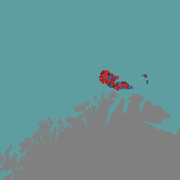
This dataset contains sea surface current observations from High-Frequency (HF) radars. Sea surface currents measured by HF radar are an average over the top 0.3-2.5 m of the water column, depending on the operating central frequency.
This dataset provides total velocity components. It comprises gridded maps of total velocity fields of the surface current averaged over a time interval. Total velocities are derived using an un-weighted least-square fit that maps radial velocities, measured by individual measurement stations, onto a Cartesian grid. The final product is a map of the zonal and meridional components of the ocean currents on a regular grid in the area of overlap of two or more radar stations.
For more details refer to this user manual
BigQuery Table Schema
Table Schema
| Name | Type | Description |
|---|---|---|
| TIME | DATETIME | Datetime of the observation |
| LATITUDE | DOUBLE | Latitude of the observation |
| LONGITUDE | DOUBLE | Longitude of the observation |
| DEPTH | DOUBLE | Number of depth levels |
| DEPH | DOUBLE | Depth of the observation (m) |
| GDOP | DOUBLE | Geometric Dilution of Precision |
| DDNS_QC | INT | Quality control flag for DDNS.
Note that a valid value for the corresponding variable has a QC bit equal to 1, 2, 5, 7, or 8. |
| CSPD_QC | INT | Quality control flag for CSPD.
Note that a valid value for the corresponding variable has a QC bit equal to 1, 2, 5, 7, or 8. |
| VART_QC | INT | Quality control flag for VART.
Note that a valid value for the corresponding variable has a QC bit equal to 1, 2, 5, 7, or 8. |
| GDOP_QC | INT | Quality control flag for GDOP.
Note that a valid value for the corresponding variable has a QC bit equal to 1, 2, 5, 7, or 8. |
| QCflag | INT | Overall quality flag |
| EWCT | DOUBLE | Surface Eastward sea water velocity (m/s) |
| NSCT | DOUBLE | Surface Northward sea water velocity (m/s) |
| EWCS | DOUBLE | Standard Deviation Of Surface Eastward Sea Water Velocity (m/s) |
| NSCS | DOUBLE | Standard Deviation Of Surface Northward Sea Water Velocity (m/s) |
| CCOV | DOUBLE | Covariance of Surface Sea Water Velocity (m^2/s^2) |
| POSITION_QC | INT | Quality control flag for POSITION.
Note that a valid value for the corresponding variable has a QC bit equal to 1, 2, 5, 7, or 8. |
| SDN_STATION | STRING | Station identifier |
| TIME_QC | INT | Quality control flag for TIME.
Note that a valid value for the corresponding variable has a QC bit equal to 1, 2, 5, 7, or 8. |
| DEPH_QC | INT | Quality control flag for DEPH.
Note that a valid value for the corresponding variable has a QC bit equal to 1, 2, 5, 7, or 8. |
| geometry | GEOMETRY | Geographic location of the observation |
Terms of Use
The data is provided free of charge by the Copernicus Marine Service. Users must acknowledge the Copernicus Marine Service as the data source when using the data. More details on the terms of use can be found on the Copernicus Marine Service website.
Terms of Use
Terms of Use
The data is provided free of charge by the Copernicus Marine Service. Users must acknowledge the Copernicus Marine Service as the data source when using the data. More details on the terms of use can be found on the Copernicus Marine Service website.
Explore with Earth Engine
Code Editor (JavaScript)
// This script loads a large BigQuery table and performs per-feature operations,
// which can make it take longer to load than typical Earth Engine scripts.
var dataset = ee.FeatureCollection.loadBigQueryTable("earth-engine-public-data.insitu_nrt_currents.radar_total_latest")
                  .filter(ee.Filter.date('2025-04-01', '2025-04-02'))
                  .filter(ee.Filter.notNull(['EWCT']));

dataset = dataset.map(function(f) {
  var val = ee.Number(f.get('EWCT')).float();
  return f.buffer(3000) // 3km radius circles
          .set('EWCT', val);
});


var image = dataset.reduceToImage({
  properties: ['EWCT'],
  reducer: ee.Reducer.first()
});

var visParams = {
  min: -0.5,
  max: 0.5,
  palette: ['a50026', 'd73027', '333333', '4575b4', '313695'],
};

Map.setCenter(25.5, 71.5, 6);
Map.addLayer(image, visParams, 'Radar Total EWCT');