Page Summary
-
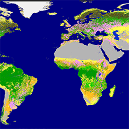
The Copernicus Global Land Service provides a 100m resolution global land cover map (CGLS-LC100) for 2015-2019, derived from PROBA-V time-series data.
-
This dataset includes both discrete land cover classes and continuous field layers showing proportional estimates for different vegetation/ground cover types.
-
The product has an accuracy of 80% at Level1 and plans for yearly updates using Sentinel data from 2020 onwards.
-
Access to this land cover dataset is completely free and open to all users.
- Dataset Availability
- 2015-01-01T00:00:00Z–2019-12-31T23:59:59Z
- Dataset Producer
- Copernicus
- Tags
Description
The Copernicus Global Land Service (CGLS) is earmarked as a component of the Land service to operate a multi-purpose service component that provides a series of bio-geophysical products on the status and evolution of land surface at global scale.
The Dynamic Land Cover map at 100 m resolution (CGLS-LC100) is a new product in the portfolio of the CGLS and delivers a global land cover map at 100 m spatial resolution. The CGLS Land Cover product provides a primary land cover scheme. Next to these discrete classes, the product also includes continuous field layers for all basic land cover classes that provide proportional estimates for vegetation/ground cover for the land cover types. This continuous classification scheme may depict areas of heterogeneous land cover better than the standard classification scheme and, as such, can be tailored for application use (e.g. forest monitoring, crop monitoring, biodiversity and conservation, monitoring environment and security in Africa, climate modelling, etc.).
These consistent Land Cover maps (v3.0.1) are provided for the period 2015-2019 over the entire Globe, derived from the PROBA-V 100 m time-series, a database of high quality land cover training sites and several ancillary datasets, reaching an accuracy of 80% at Level1 over all years. It is planned to provide yearly updates from 2020 through the use of a Sentinel time-series.
See also:
Bands
Bands
Pixel size: 100 meters (all bands)
| Name | Units | Min | Max | Pixel Size | Description |
|---|---|---|---|---|---|
discrete_classification |
0 | 200 | 100 meters | Land cover classification |
|
discrete_classification-proba |
% | 0 | 100 | 100 meters | Quality indicator (classification probability) of the discrete classification |
forest_type |
0 | 5 | 100 meters | Forest type for all pixels with tree percentage vegetation cover bigger than 1 % |
|
bare-coverfraction |
% | 0 | 100 | 100 meters | Percent vegetation cover for bare-sparse-vegetation land cover class |
crops-coverfraction |
% | 0 | 100 | 100 meters | Percent vegetation cover for cropland land cover class |
grass-coverfraction |
% | 0 | 100 | 100 meters | Percent vegetation cover for herbaceous vegetation land cover class |
moss-coverfraction |
% | 0 | 100 | 100 meters | Percent vegetation cover for moss and lichen land cover class |
shrub-coverfraction |
% | 0 | 100 | 100 meters | Percent vegetation cover for shrubland land cover class |
tree-coverfraction |
% | 0 | 100 | 100 meters | Percent vegetation cover for forest land cover class |
snow-coverfraction |
% | 0 | 100 | 100 meters | Percent ground cover for snow and ice land cover class |
urban-coverfraction |
% | 0 | 100 | 100 meters | Percent ground cover for built-up land cover class |
water-permanent-coverfraction |
% | 0 | 100 | 100 meters | Percent ground cover for permanent water land cover class |
water-seasonal-coverfraction |
% | 0 | 100 | 100 meters | Percent ground cover for seasonal water land cover class |
data-density-indicator |
0 | 100 | 100 meters | Data density indicator for algorithm input data |
|
change-confidence |
0 | 3 | 100 meters | This layer is only provided for years after the BaseYear 2015.
|
discrete_classification Class Table
| Value | Color | Description |
|---|---|---|
| 0 | #282828 | Unknown. No or not enough satellite data available. |
| 20 | #ffbb22 | Shrubs. Woody perennial plants with persistent and woody stems and without any defined main stem being less than 5 m tall. The shrub foliage can be either evergreen or deciduous. |
| 30 | #ffff4c | Herbaceous vegetation. Plants without persistent stem or shoots above ground and lacking definite firm structure. Tree and shrub cover is less than 10 %. |
| 40 | #f096ff | Cultivated and managed vegetation / agriculture. Lands covered with temporary crops followed by harvest and a bare soil period (e.g., single and multiple cropping systems). Note that perennial woody crops will be classified as the appropriate forest or shrub land cover type. |
| 50 | #fa0000 | Urban / built up. Land covered by buildings and other man-made structures. |
| 60 | #b4b4b4 | Bare / sparse vegetation. Lands with exposed soil, sand, or rocks and never has more than 10 % vegetated cover during any time of the year. |
| 70 | #f0f0f0 | Snow and ice. Lands under snow or ice cover throughout the year. |
| 80 | #0032c8 | Permanent water bodies. Lakes, reservoirs, and rivers. Can be either fresh or salt-water bodies. |
| 90 | #0096a0 | Herbaceous wetland. Lands with a permanent mixture of water and herbaceous or woody vegetation. The vegetation can be present in either salt, brackish, or fresh water. |
| 100 | #fae6a0 | Moss and lichen. |
| 111 | #58481f | Closed forest, evergreen needle leaf. Tree canopy >70 %, almost all needle leaf trees remain green all year. Canopy is never without green foliage. |
| 112 | #009900 | Closed forest, evergreen broad leaf. Tree canopy >70 %, almost all broadleaf trees remain green year round. Canopy is never without green foliage. |
| 113 | #70663e | Closed forest, deciduous needle leaf. Tree canopy >70 %, consists of seasonal needle leaf tree communities with an annual cycle of leaf-on and leaf-off periods. |
| 114 | #00cc00 | Closed forest, deciduous broad leaf. Tree canopy >70 %, consists of seasonal broadleaf tree communities with an annual cycle of leaf-on and leaf-off periods. |
| 115 | #4e751f | Closed forest, mixed. |
| 116 | #007800 | Closed forest, not matching any of the other definitions. |
| 121 | #666000 | Open forest, evergreen needle leaf. Top layer- trees 15-70 % and second layer- mixed of shrubs and grassland, almost all needle leaf trees remain green all year. Canopy is never without green foliage. |
| 122 | #8db400 | Open forest, evergreen broad leaf. Top layer- trees 15-70 % and second layer- mixed of shrubs and grassland, almost all broadleaf trees remain green year round. Canopy is never without green foliage. |
| 123 | #8d7400 | Open forest, deciduous needle leaf. Top layer- trees 15-70 % and second layer- mixed of shrubs and grassland, consists of seasonal needle leaf tree communities with an annual cycle of leaf-on and leaf-off periods. |
| 124 | #a0dc00 | Open forest, deciduous broad leaf. Top layer- trees 15-70 % and second layer- mixed of shrubs and grassland, consists of seasonal broadleaf tree communities with an annual cycle of leaf-on and leaf-off periods. |
| 125 | #929900 | Open forest, mixed. |
| 126 | #648c00 | Open forest, not matching any of the other definitions. |
| 200 | #000080 | Oceans, seas. Can be either fresh or salt-water bodies. |
forest_type Class Table
| Value | Color | Description |
|---|---|---|
| 0 | #282828 | Unknown |
| 1 | #666000 | Evergreen needle leaf |
| 2 | #009900 | Evergreen broad leaf |
| 3 | #70663e | Deciduous needle leaf |
| 4 | #a0dc00 | Deciduous broad leaf |
| 5 | #929900 | Mix of forest types |
Image Properties
Image Properties
| Name | Type | Description |
|---|---|---|
| discrete_classification_class_names | STRING_LIST | Land cover class names |
| discrete_classification_class_palette | STRING_LIST | Land cover class palette |
| discrete_classification_class_values | INT_LIST | Value of the land cover classification. |
| forest_type_class_names | STRING_LIST | forest cover class names |
| forest_type_class_palette | STRING_LIST | forest cover class palette |
| forest_type_class_values | INT_LIST | forest cover class values |
Terms of Use
Terms of Use
As official product of the global component of the Copernicus Land Service, access to this land cover dataset is fully free and open to all users.
Citations
Buchhorn, M. ; Lesiv, M. ; Tsendbazar, N. - E. ; Herold, M. ; Bertels, L. ; Smets, B. Copernicus Global Land Cover Layers-Collection 2. Remote Sensing 2020, 12Volume 108, 1044. doi:10.3390/rs12061044
Buchhorn, M., Smets, B., Bertels, L., Roo, B. D., Lesiv, M., Tsendbazar, N.-E., Herold, M., & Fritz, S. (2020). Copernicus Global Land Service: Land Cover 100m: collection 3: epoch 2017: Globe (Version V3.0.1) [Data set]. Zenodo.
Buchhorn, M., Smets, B., Bertels, L., Roo, B. D., Lesiv, M., Tsendbazar, N.-E., Herold, M., & Fritz, S. (2020). Copernicus Global Land Service: Land Cover 100m: collection 3: epoch 2018: Globe (Version V3.0.1) [Data set]. Zenodo.
Buchhorn, M., Smets, B., Bertels, L., Roo, B. D., Lesiv, M., Tsendbazar, N.-E., Herold, M., & Fritz, S. (2020). Copernicus Global Land Service: Land Cover 100m: collection 3: epoch 2015: Globe (Version V3.0.1) [Data set]. Zenodo.
Buchhorn, M., Smets, B., Bertels, L., Roo, B. D., Lesiv, M., Tsendbazar, N.-E., Herold, M., & Fritz, S. (2020). Copernicus Global Land Service: Land Cover 100m: collection 3: epoch 2019: Globe (Version V3.0.1) [Data set]. Zenodo.
DOIs
- https://doi.org/10.5281/ZENODO.3518036
- https://doi.org/10.5281/ZENODO.3518038
- https://doi.org/10.5281/ZENODO.3939038
- https://doi.org/10.5281/ZENODO.3939050
- https://doi.org/10.5281/zenodo.3518026
- https://doi.org/10.5281/zenodo.3518036
- https://doi.org/10.5281/zenodo.3518038
- https://doi.org/10.5281/zenodo.3939038
- https://doi.org/10.5281/zenodo.3939050
Explore with Earth Engine
Code Editor (JavaScript)
var dataset = ee.Image('COPERNICUS/Landcover/100m/Proba-V-C3/Global/2019')
.select('discrete_classification');

Map.setCenter(-88.6, 26.4, 1);

Map.addLayer(dataset, {}, 'Land Cover');
import ee
import geemap.core as geemap
Colab (Python)
dataset = ee.Image('COPERNICUS/Landcover/100m/Proba-V-C3/Global/2019').select(
    'discrete_classification'
)

m = geemap.Map()
m.set_center(-88.6, 26.4, 1)
m.add_layer(dataset, {}, 'Land Cover')
m