
ContrailWatch is a set of flight-level contrail attributions for past flights.
While not directly used for flight planning, contrail attributions are important for training, evaluation, and educational purposes. We hope that this data will be used to accelerate contrail research.
Methodologies
To support different research and analysis needs, the Contrails API
offers three distinct attribution methodologies using a view parameter:
OBSERVATION
OBSERVATION is the default mode and attributes impact based only on matched
satellite contrail detections. Flight segments with no matched contrail
detection report zero impact.
This mode prioritizes high precision based on direct, observed evidence.
This view matches satellite detections to flight paths using methods described in Sarna et al. 2025 and builds on top of Geraedts et al. 2023.
COCIP
COCIP attributes impact based solely on physical modeling (CoCiP
ensemble predictions using 10 members). Flight paths are fully interpolated
using great-circle paths over data gaps.
This mode prioritizes high recall.
This view utilizes physical modeling described in Schumann 2012.
OBSERVATION_ENHANCED_COCIP
OBSERVATION_ENHANCED_COCIP is a hybrid approach that fuses satellite
observations with CoCiP ensemble predictions to estimate the total physical
radiative impact.
The Contrails API provides the best estimate of physical radiative energy forcing derived by extracting effective radiative forcing from 4D gridded CoCiP forecast outputs and linearly interpolating them along the resampled flight points. The methodology for estimating energy forcing is an active area of research and may change in future versions.
This approach:
- Scales or discounts physical model predictions based on matched satellite detections where coverage permits.
- Relies directly on physical modeling in regions outside of satellite coverage as well as for flight path data gaps which are inherently not suitable for matching.
This view fuses matched satellite contrail detections with CoCiP predictions based on the methodology presented in Geraedts et al. 2026 (preprint).
Usage
ContrailWatch attributions have been used to train ML-based contrail forecasts, evaluate contrail avoidance trials, and to provide insights into contrail formation patterns.
Example
This example image is a frame of GOES-16 satellite imagery sequence over the Gulf Coast area. It was used for evaluating whether a contrail avoidance flight created a detectable contrail.
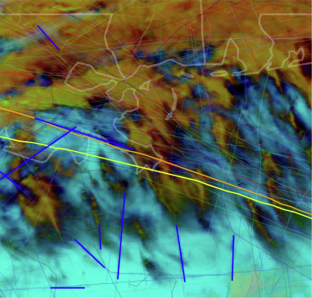
Thick lines show the original flight path and wind-advected flight trajectory, along with contrails detected by the computer vision system. More details available in the original paper.
Limitations
ContrailWatch attributions come with the following limitations:
Geographical coverage: Regional constraints apply only to operations relying on satellite imagery (the
OBSERVATIONview and the observational adjustment segments ofOBSERVATION_ENHANCED_COCIP). These are limited to subregions covered by GOES-East (Continental US), MTG (Continental Europe), and Himawari (subregions of East Asia / Asia-Pacific). GOES-East and Himawari attributions provide production-level quality, while MTG is in beta. For areas outside these defined coverage regions, or for the pure physics view (COCIP), flight assessments are computed globally by defaulting to model predictions.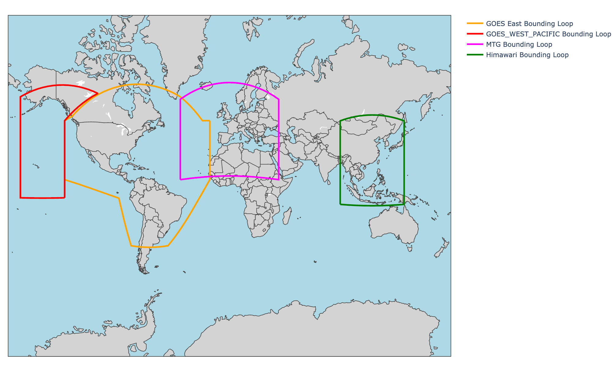
The preceding map illustrates the specific bounds used for processing data these observation-based views.
Formation-focused & energy forcing estimates: Attributions are based on observations of contrail formation from satellite imagery or physical simulation rather than direct real-time measurement of radiative forcing.
Recall: Observation-only attributions may not represent the full extent of contrail formation over a region.
Understanding the percentage of contrail formation that is observable in satellite imagery is an open research question. Research indicates that around half of all contrails are detectable by geostationary satellites, with the overwhelming majority of warming coming from contrails that are detectable at some point in their lifetime (Driver et al. 2025).
License
The data exposed by the ContrailWatch API is licensed under CC BY-NC 4.0.
References
Geraedts, Scott, Erica Brand, Thomas R. Dean, Sebastian Eastham, Carl Elkin, Zebediah Engberg, Ulrike Hager, et al. 2023. A Scalable System to Measure Contrail Formation on a per-Flight Basis. Environmental Research Communications, http://doi.org/10.1088/2515-7620/ad11ab.
Sarna, A., Meijer, V., Chevallier, R., Duncan, A., McConnaughay, K., Geraedts, S., and McCloskey, K.: Benchmarking and improving algorithms for attributing satellite-observed contrails to flights, Atmospheric Measurement Techniques, https://doi.org/10.5194/amt-18-3495-2025.
Schumann, U. 2012. A Contrail Cirrus Prediction Model. Geoscientific Model Development 5 (3): 543-80.
John C Platt, Marc L Shapiro, Zebediah Engberg, Kevin McCloskey, Scott Geraedts, Tharun Sankar, Marc E J Stettler, Roger Teoh, Ulrich Schumann, Susanne Rohs: The effect of uncertainty in humidity and model parameters on the prediction of contrail energy forcing 2024 Environ. Res. Commun. 6 095015
Driver, O. G. A., Stettler, M. E. J., and Gryspeerdt, E.: Factors limiting contrail detection in satellite imagery, Atmos. Meas. Tech., 18, 1115–1134, https://doi.org/10.5194/amt-18-1115-2025, 2025.
Geraedts, Scott, Aaron Sarna, Susanne Rohs, Roger Teoh, and Kevin McCloskey. 2026. Improving reanalysis weather for contrail validation by incorporating satellite observations. Copernicus Preprints, https://jecats.copernicus.org/preprints/jecats-2026-6/.