Google 災害示警簡介
透過集合功能整理內容
你可以依據偏好儲存及分類內容。
Google 災害示警是 Google 用來發布緊急訊息的平台。常見的警報類型包括天氣相關警報 (例如熱帶風暴、洪水和龍捲風),以及地震和其他公共安全事件資訊。目標是在你使用 Google 搜尋和 Google 地圖進行搜尋,以及在 Android 裝置上啟用 Google 即時服務時,在災害示警首頁 (www.google.org/publicalerts) 顯示與搜尋內容相關的全球官方天氣、公共安全和地震示警。
Google 災害示警可讓使用者在自然災害發生時更容易取得重要資訊。這項服務可大規模地向大眾提供緊急救援資訊,並以可行動的方式呈現資訊。將警示內容傳送給 Google,確保受影響的使用者能掌握最新資訊。
關於這個網站
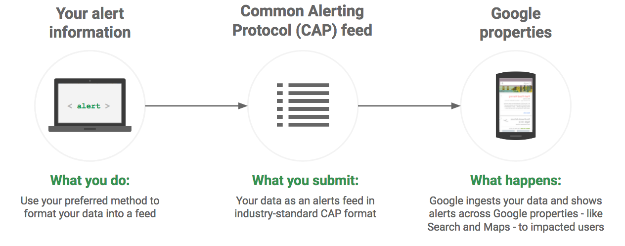
網站會強調 Google 需要您提供哪些資料,才能顯示 Google 災害示警、您準備資料並與 Google 分享的必要步驟,以及整體整合程序。資料採用通用警報通訊協定 (CAP) 格式,這是專為傳送警報而設計的非專屬業界標準規格。格式會定義如何指定警示的詳細資料,例如指定地理區域、生效時間、到期時間,以及如何更新或取消警示。
誰可以發布 Google 災害示警
發布 Google 災害示警的合作夥伴必須符合以下條件:
- 公共安全機關或提供影響人身安全和財產安全資訊的公共警報供應商,以及
- 您必須是警示資訊的原始且權威作者,或是擁有原始作者授予的權利,可匯總和/或發布這項資訊。
所有氣象局都應向 世界氣象組織警報主管機關登記處登記。在美國,我們也建議合作夥伴成為認證的 IPAWS 公共警報機構。
Google 災害示警整合
示警資料來自合作夥伴,並已整合至 Google 搜尋、Google 地圖和 Google Now 資訊卡。警報包含事件說明、事件發生地點和時間,以及事件受影響者應採取的任何可能行動。
Google 搜尋
電腦和行動裝置搜尋會在使用者相關的時間點和位置觸發快訊。您提供的警報資訊會定義緊急或警告狀態所影響的區域,以及事件的嚴重程度。除了這些資訊之外,決定誰會看到這則快訊的因素還包括使用者的查詢和使用者裝置的位置。舉例來說,與位於受影響地區的使用者相比,位於非受影響地區的使用者可能需要輸入更詳細的搜尋查詢,才能看到警報。
快訊會產生警告,使用者可以點選查看更多資訊。
Google 地圖
Google 地圖會向電腦、平板電腦和手機使用者顯示地理資料。
在電腦或行動應用程式中搜尋某個區域時,系統會顯示該區域附近的相關警報。行動應用程式也會針對相關快訊提供地點警告通知。
Google 即時資訊
Google 即時服務會根據裝置位置提供相關的警報通知。通知會說明發生的狀況、受影響的地區,以及可能需要採取的安全措施。
Google 災害示警的運作方式
- 合作夥伴會以業界標準的通用警報通報協定 (CAP) 格式設定資料。
- 合作夥伴會透過動態饋給傳送 CAP 格式資料。
- Google 會擷取資料並發布。請注意,由於資料格式是業界標準,因此可提供給任何支援通用警報通訊協定的下游使用者。

arrow_forward 開始使用 Google 災害示警
除非另有註明,否則本頁面中的內容是採用創用 CC 姓名標示 4.0 授權,程式碼範例則為阿帕契 2.0 授權。詳情請參閱《Google Developers 網站政策》。Java 是 Oracle 和/或其關聯企業的註冊商標。
上次更新時間:2025-05-08 (世界標準時間)。
[[["容易理解","easyToUnderstand","thumb-up"],["確實解決了我的問題","solvedMyProblem","thumb-up"],["其他","otherUp","thumb-up"]],[["缺少我需要的資訊","missingTheInformationINeed","thumb-down"],["過於複雜/步驟過多","tooComplicatedTooManySteps","thumb-down"],["過時","outOfDate","thumb-down"],["翻譯問題","translationIssue","thumb-down"],["示例/程式碼問題","samplesCodeIssue","thumb-down"],["其他","otherDown","thumb-down"]],["上次更新時間:2025-05-08 (世界標準時間)。"],[[["Google Public Alerts delivers emergency messages, such as weather warnings and public safety information, through various Google platforms like Search, Maps, and Google Now."],["The system uses the Common Alerting Protocol (CAP) format, an industry standard for transmitting alert data, ensuring broad compatibility."],["Public safety agencies and authorized alert providers can publish alerts on Google Public Alerts, provided they meet specific criteria regarding information authority."],["Google Public Alerts integrates with Google products like Search, Maps, and Google Now, displaying relevant alerts based on user location and search queries, increasing visibility and accessibility."],["The system operates by partners formatting data in CAP, transmitting it to Google, which then ingests and publishes the alerts for public consumption."]]],["Google Public Alerts disseminates emergency messages, including weather warnings and earthquake alerts, through Google Search, Maps, and Now. Partners, who must be official public safety agencies, provide data in the Common Alerting Protocol (CAP) format. This data is transmitted in a feed, ingested by Google, and published. Alerts are triggered by user queries and location, displaying event descriptions, affected areas, and safety actions. The data format ensures broader accessibility to other platforms that support CAP.\n"]]