
Page Summary
-
Applications using the Maps JavaScript API must provide publicly accessible Terms of Use and a Privacy Policy that incorporates Google's Terms of Service and Privacy Policy, respectively.
-
Content pre-fetching, caching, or storage is generally restricted, but place IDs are exempt, allowing for saving and managing them.
-
Maps JavaScript API results must be displayed on Google Maps; if displayed without a map, a Google logo is required with proper attribution.
-
Attribution must be clear, legible, unmodified, and positioned correctly, including third-party data providers when applicable, and cannot be moved away from the content.
-
When displaying reviews or photos obtained through the API, ensure proper attribution is provided for authors and sources, following guidelines for author names, photos, and links.
This document lists requirements for applications developed with the Maps JavaScript API. Note that use of the Maps JavaScript API is governed by your Agreement with Google.
Policies
This section describes policies relevant to Maps JavaScript API. Policies provide practical implementation guidelines and requirements to help you use the Service correctly and in line with Google Maps Platform's expectations.
Exceptions from caching restrictions
Note that the place ID, used to uniquely identify a place, is
exempt from the caching restrictions.
You can therefore store place ID values indefinitely.
The place ID is returned in the place_id field in
API responses. Learn how to save, refresh, and manage place IDs in the Place IDs guide.
Content scraping
Place Name may be returned to you based on user interactions with your app. If you were to capture or persist the Place Name for use in any other context outside of the user session, this would constitute scraping, which is not allowed by our terms.
European Economic Area countries and territories
This product has different Terms of Service for customers with a billing address in the European Economic Area (EEA), and it may also have different functionality. Before building with Google Maps Platform, review the following EEA-specific terms and information:
- Google Maps Platform EEA Terms of Service
- Google Maps Platform EEA Service Specific Terms
- EEA frequently asked questions (FAQ)
- Google Maps Platform Road Safety Requirements
If your billing address is not in the EEA, the following terms of service apply to you:
Google Maps attribution requirements
This section provides attribution requirements and guidelines for displaying Google Maps and Content through your applications.
Attribution example
Following is an attribution example for Places UI Kit.

Display Google Maps attribution
You must follow Google Maps attribution requirements when displaying Content from Google Maps Platform APIs in your app or website. You don't need to add extra attribution if the Content is shown on a Google Map where the attribution is already visible.
Included Google Maps attribution
For Google Maps attribution that is already provided by Google Maps Platform in the user interface, such as in Places UI Kit:
- Don't remove included attribution regardless of where it is displayed. Don't alter, hide, or obscure the attribution and make sure it is clearly visible against the background.
- Always visually distinguish Google Maps Platform Content from other content by using UI cues such as a border, background color, shadow, or sufficient whitespace.
- When making visual modifications, you must adhere to all Google Maps attribution requirements.
Google Maps logo and text attribution
Attribution should take the form of the Google Maps logo whenever possible. In cases where space is limited, the text Google Maps is acceptable. It must always be clear to end users which content is provided by Google Maps.
Logo attribution
Follow these requirements for using the Google Maps logo in your app or website.Download Google Maps logos
Use the official Google Maps logo files. Download the logos below, and follow the guidelines in this section.
Download the Google Maps attribution assetsWhen using the Google Maps logo, follow these guidelines.
- Don't modify the logo in any way.
- Maintain the aspect ratio of the logo to prevent distortion.
- Use the outlined logo on a busy background, like a map or image.
- Use the non-outlined logo on a plain background, like a solid color or subtle gradient.
Logo size specification
Follow these size specifications for the Google Maps logo:- Minimum logo height: 16dp
- Maximum logo height: 19dp
- Minimum logo clear space: 10dp on left, right and top, 5dp on the bottom
To learn about dp, see Pixel density on the Material Design website.
Logo accessibility
Follow these accessibility requirements for the Google Maps logo:- Maintain an accessible contrast between the logo and the background.
- Include an accessibility label with the text Google Maps.
Text attribution
If the size of your interface does not support using the Google Maps logo, you can spell out Google Maps in text. Follow these guidelines:

- Don't modify the text Google Maps in any way:
- Don't change the capitalization of Google Maps
- Don't wrap Google Maps onto multiple lines
- Don't localize Google Maps into another language.
- Prevent browsers from translating Google Maps by using the HTML attribute
translate="no".

Style Google Maps text as described in the following table:
Google Maps text-styling requirements Property Style Font family Roboto. Loading the font is optional. Fallback font family Any sans serif body font already used in your product or "Sans-Serif" to invoke the default system font Font style Normal Font weight 400 Font color White, black (#1F1F1F), or gray (#5E5E5E). Maintain accessible (4.5:1) contrast against the background. Font size Minimum font size: 12sp
Maximum font size: 16sp
To learn about sp, see Font size units on the Material Design website.Letter spacing Normal
Example CSS
The following CSS renders Google Maps with the appropriate typographic style and color on a white or light background.
@import url('https://fonts.googleapis.com/css2?family=Roboto&display=swap');

.GMP-attribution {
font-family: Roboto, Sans-Serif;
font-style: normal;
font-weight: 400;
font-size: 1rem;
letter-spacing: normal;
white-space: nowrap;
color: #5e5e5e;
}
Visual requirements
Follow these requirements for the visual treatment of Google Maps attribution.Position attribution near the top or bottom of the content, and within the same visual container. For a single line of content, attribution can be positioned to the right or left.
Visually distinguish Google Maps Platform Content from other content by using UI cues such as a border, background color, shadow, or sufficient whitespace.
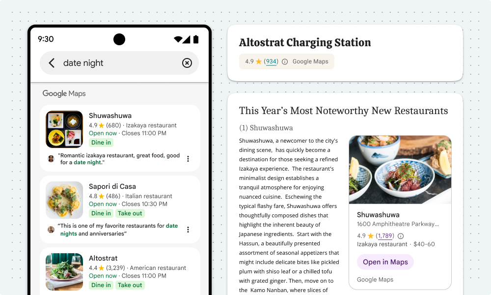
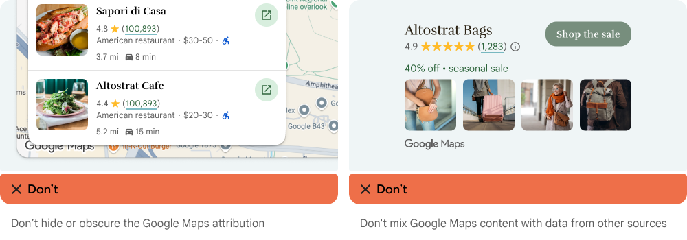
- Don't misrepresent Google Maps by attributing it with non-Google Maps Platform content.
- Verify that the attribution is always visible and legible. Never remove, hide, obscure, or modify it.
The following figures show examples of these visual requirements.

Third-party data providers
Some of the data and images on our mapping products come from providers other than Google. For some products, such as Map Tiles API, we may provide you with the required attribution to the third-party data provider. When we do, the text of your attribution must say the name "Google Maps" and the relevant data provider(s), such as "Map data: Google, Maxar Technologies." When Google provides third-party attribution, only including "Google Maps" or the Google logo is not proper attribution.
Other attribution requirements
Follow these instructions to retrieve third-party attributions, and to display the attributions in your app.
Retrieve attributions from a Place
If your app displays review information obtained by calling
Place.fetchFields,
the app must also display third-party attributions for the place details obtained.
The API returns a Place
object. To retrieve attributions from the Place object, use the
Place.attributions
property, which is returned with every request (there is no need to specify it with fields). The
property returns a List of String objects, or null if there
are no attributions to display. The following example code shows getting a place, and listing any
attributions.
  // Use place ID to create a new Place instance.
  const place = new Place({
      id: 'ChIJB9a4Ifl744kRlpz0BQJzGQ8', // Crazy Good Kitchen
  });

  // Call fetchFields, passing the desired data fields.
  await place.fetchFields({
      fields: ["displayName", "formattedAddress", "location", "reviews"],
  });

  // Check for any place attributions.
  if (!place.attributions) {
      console.log('No attributions were found.');
      return;
  } else {
      // Log the place attribution
      for (var attribution of place.attributions) {
          console.log(attribution);
      }
  }
Display a review
A Place object can contain up to five reviews, where each review is represented by a
Review object. You can optionally display these reviews in your app.
When displaying reviews contributed by Google users, you must place the author's name in close
proximity. When available in the author attribution field of the Review object, we
recommend you include the author's photo and link to their profile as well. The following image
shows an example of a review of a park:

The following example shows getting a place, checking for reviews, and showing the data from the first review:
  // Use place ID to create a new Place instance.
  const place = new Place({
    id: "ChIJpyiwa4Zw44kRBQSGWKv4wgA", // Faneuil Hall Marketplace, Boston, MA
  });

  // Call fetchFields, passing "reviews" and other needed fields.
  await place.fetchFields({
      fields: ["displayName", "formattedAddress", "location", "reviews"],
  });

  // If there are any reviews display the first one.
  if (!place.reviews) {
      console.log('No reviews were found.');
  } else {
      // Log the review count so we can see how many there are.
      console.log("REVIEW COUNT: " + place.reviews.length);

      // Get info for the first review.
      let reviewRating = place.reviews[0].rating;
      let reviewText = place.reviews[0].text;
      let authorName = place.reviews[0].authorAttribution.displayName;
      let authorUri = place.reviews[0].authorAttribution.uri;

      // Create a bit of HTML to add to the info window
      const contentString =
        '<div id="title"><b>' + place.displayName + '</b></div>' +
        '<div id="address">' + place.formattedAddress + '</div>' +
        '<a href="' + authorUri + '" target="_blank">Author: ' + authorName + '</a>' +
        '<div id="rating">Rating: ' + reviewRating + ' stars</div>' +
        '<div id="rating""><p>Review: ' + reviewText + '</p></div>';

      // Create an info window.
      infoWindow = new InfoWindow({
          content: contentString,
          ariaLabel: place.displayName,
      });

      // Add a marker for the place.
      const marker = new AdvancedMarkerElement({
          map,
          position: place.location,
          title: place.displayName,
      });

      // Show the info window.
      infoWindow.open({
          anchor: marker,
          map,
      });
  }
See the documentation for place reviews.
Display attributions for a photo
If your app displays photos, you must show author attributions for each photo that has them.
Details about the photo in a Place object of a response are contained in the
photos array. To add the photos array to the response, include the
photos data field in the request.
Each element of the photos array is an instance of Photo, which contains the
authorAttributions array, of type AuthorAttribution. The fields of the
AuthorAttribution object are strings containing the displayName,
uri, and photoUri of the attribution, or an empty string if there are no
attributions to display.
See the documentation for place photos.
Search results attributions
In Europe, when using Google's unadulterated ranking, search products must have explainer text no more than 1 click away that describes the main factors and the weighting of the main factors that determine search results ranking. Explainer text:
Header: About these results
Body: When you search for businesses or places near a location, Google Maps will show you local results. Several factors — primarily relevance, distance and prominence — are combined to help find the best results for your search.
Button 1: Learn more
"Learn more" text should link to a Help Center article.
Button 2: OK
Autocomplete for end user addresses
When an end user uses Autocomplete functionality within your Customer Application to type ahead a street address and that street address would have been completely and accurately provided by that end user without Autocomplete, the end user's selected address is then not subject to the Google Maps Content restrictions in your Google Maps Platform Agreement. This exception applies only to the street address selected by the end user and solely for that end user's specific transaction; it does not apply to the list of suggested addresses provided by the Autocomplete functionality or to other Google Maps Content. This exception does not apply to any POI or address lookup functionality offered by other Google Maps Platform Services.

In the previous image, the address list on the left is still subject to the restrictions on Google Maps Content. Once the end user selects their chosen address, that address is not subject to the restrictions on Google Maps Content solely for the purpose of that end user's applicable transaction.
AI-powered summaries
When you display AI-powered summaries in your app — including place, area, and review summaries — you must do the following:
- Display the required attributions, reporting links, and reference links as defined below.
- End users must be able to read the full summary text as it is provided by Google Maps.
Display AI-powered summaries disclosure text
When displaying an AI-powered summary of any type, always include the localized
disclosure text (provided in the disclosureText field of the response body)
immediately below the summary. Never modify or augment the disclosure text
provided by the API.

Place and area summary additional requirements
Place and area summaries displayed in your app must be accompanied by the following text and required links:
| Text | Requirement |
|---|---|
| About this summary | Use the following link to "How Google sources and uses information in local listings": https://support.google.com/local-listings/answer/9851099. |
| Report summary |
Use the link contained in the Note: AI-powered summaries provided through the Places API (New) are subject to Google's content and product policies wherever you are in the world. You are required to notify your end users that if they would like to report content that should be removed from Google's services under applicable laws, they should report it using the provided flag content URL ( |

Review summary requirements
Review summaries displayed in your app must be accompanied by a heading with the text "Review summary." Additionally, you must use the following text and required links:
| Text | Requirement |
|---|---|
| About this summary | Use the following link to "How Google sources and uses information in local listings": https://support.google.com/local-listings/answer/9851099 |
| Report summary |
Use the link contained in the Note: AI-powered summaries provided through the Places API (New) are subject to Google's content and product policies wherever you are in the world. You are required to notify your end users that if they would like to report content that should be removed from Google's services under applicable laws, they should report it using the provided flag content URL ( |
| See reviews | Use the link contained in the reviewSummary.reviewsUri field of the response. |

Display guidance for automotive use cases
For driver safety, Google recommends rendering AI-powered summaries in parked mode for automotive experiences. If rendering summaries in driving mode, on-screen information should be simple, clear, and concise to ensure that the driver's attention returns quickly to the road:
- No more than 3 lines
- 120 characters or 24 words or less
- Minimum front size of 24dp
Especially in automotive contexts, it's the developer's responsibility to render AI-powered summaries in ways that are safe and compliant with all local laws and regulations.