Page Summary
-
DEM-H is a hydrologically enforced digital elevation model derived from SRTM data that captures flow paths based on SRTM elevations and mapped stream lines.
-
DEM-S is a smoothed digital elevation model also derived from SRTM data that represents ground surface topography and has been smoothed to reduce noise and improve surface shape representation.
-
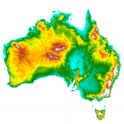
DEM-H: Australian SRTM Hydrologically Enforced Digital Elevation Model

The Hydrologically Enforced Digital Elevation Model (DEM-H) was derived from the SRTM data acquired by NASA in February 2000. The model has been hydrologically conditioned and drainage enforced. The DEM-H captures flow paths based on SRTM elevations and mapped stream lines, and supports delineation of … australia dem elevation elevation-topography ga geophysical -
DEM-S: Australian Smoothed Digital Elevation Model
The Smoothed Digital Elevation Model (DEM-S) was derived from the SRTM data acquired by NASA in February 2000. DEM-S represents ground surface topography (excluding vegetation features) and has been smoothed to reduce noise and improve the representation of surface shape. An adaptive process applied more … australia dem elevation elevation-topography ga geophysical