Page Summary
-
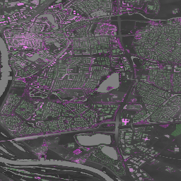
The AHN (Actueel Hoogtebestand Nederland) dataset provides detailed elevation data for the Netherlands with various versions available.
-
AHN DEM data is available in 0.5m resolution and was generated from LIDAR data collected between 2007 and 2012.
-
Different versions of the AHN DEM exist, including interpolated, non-interpolated, and raw samples, some of which remove above-ground features.
-
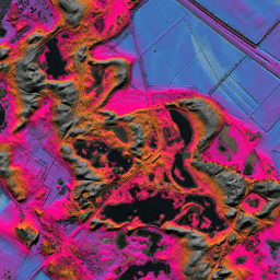
AHN3 and AHN4 datasets offer 0.5m Digital Surface Models (DSM) based on laser technology with 5 cm vertical accuracy.
-
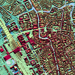
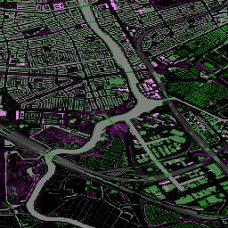
Orthophotos of the Netherlands are available as color orthoimages collected twice a year with varying resolutions depending on the season.
-
AHN Netherlands 0.5m DEM, Interpolated
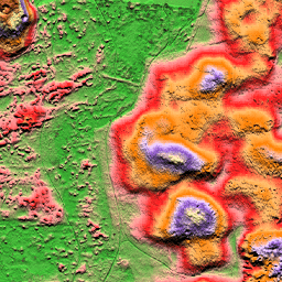
The AHN DEM is a 0.5m DEM covering the Netherlands. It was generated from LIDAR data taken in the spring between 2007 and 2012. It contains ground level samples with all other items above ground (such as buildings, bridges, trees etc.) removed. This version is … ahn dem elevation elevation-topography geophysical lidar -
AHN Netherlands 0.5m DEM, Non-Interpolated
The AHN DEM is a 0.5m DEM covering the Netherlands. It was generated from LIDAR data taken in the spring between 2007 and 2012. It contains ground level samples with all other items above ground (such as buildings, bridges, trees etc.) removed. This version is … ahn dem elevation elevation-topography geophysical lidar -
AHN Netherlands 0.5m DEM, Raw Samples
The AHN DEM is a 0.5m DEM covering the Netherlands. It was generated from LIDAR data taken in the spring between 2007 and 2012. This version contains both ground level samples and items above ground level (such as buildings, bridges, trees etc). The point cloud … ahn dem elevation elevation-topography geophysical lidar -
AHN3: Netherlands AHN 0.5m
The Actueel Hoogtebestand Nederland (AHN) is a dataset with detailed and precise elevation data for the whole of the Netherlands. Elevation information was collected from helicopters and aircraft using laser technology with vertical accuracy of 5 cm. AHN3 Dataset contains the Netherlands AHN 0.5m DSM … ahn dem elevation elevation-topography geophysical lidar -
AHN4: Netherlands AHN 0.5m
The Actueel Hoogtebestand Nederland (AHN) is a dataset with detailed and precise elevation data for the whole of the Netherlands. Elevation information was collected from helicopters and aircraft using laser technology with vertical accuracy of 5 cm. AHN4 Dataset contains the Netherlands AHN 0.5m DSM … ahn dem elevation elevation-topography geophysical lidar -
Netherlands orthophotos
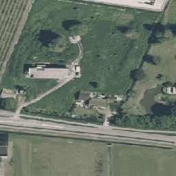
Orthophotos of Netherlands is a set of color orthoimages. Two nationwide aerial photographs are collected per year: a leafless image at 7.5 cm resolution in the spring and one with leaves on trees at 25 cm resolution in the summer. For more information, please see … netherlands orthophotos rgb