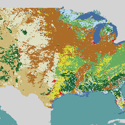
NLCD (Ulusal Arazi Örtüsü Veritabanı), 8 döneme (2001, 2004, 2006, 2008, 2011, 2013, 2016 ve 2019) yayılan 30 metrelik Landsat tabanlı bir arazi örtüsü veritabanıdır. 2021 için dokuzuncu bir dönem de burada mevcuttur. Görüntüler, kentsel alan için geçirimsizlik veri katmanını kullanır.
ABD Yerbilimsel Araştırma Kurumu (USGS), çeşitli federal kurumlarla ortaklaşa çalışarak şu ana kadar yedi Ulusal Arazi Örtüsü Veritabanı (NLCD) ürünü geliştirdi ve yayınladı: NLCD 1992, 2001, 2006, 2011, 2016, 2019 ve 2021. 2016 sürümünden itibaren, arazi örtüsü ürünleri iki ila üç yıllık aralıklarla oluşturuldu.
[[["Anlaması kolay","easyToUnderstand","thumb-up"],["Sorunumu çözdü","solvedMyProblem","thumb-up"],["Diğer","otherUp","thumb-up"]],[["İhtiyacım olan bilgiler yok","missingTheInformationINeed","thumb-down"],["Çok karmaşık / çok fazla adım var","tooComplicatedTooManySteps","thumb-down"],["Güncel değil","outOfDate","thumb-down"],["Çeviri sorunu","translationIssue","thumb-down"],["Örnek veya kod sorunu","samplesCodeIssue","thumb-down"],["Diğer","otherDown","thumb-down"]],[],[],["The USGS National Land Cover Database (NLCD) provides 30-meter land cover data from Landsat imagery. It includes nine epochs: 2001, 2004, 2006, 2008, 2011, 2013, 2016, 2019, and 2021. NLCD products have been released for seven datasets : 1992, 2001, 2006, 2011, 2016, 2019 and 2021. The 2016 release started using two-to-three-year intervals. The data, which relies on imperviousness layers for urban areas, are created in partnership with federal agencies.\n"]]