Page Summary
-
Global accessibility maps for cities and healthcare facilities are available.
-
Gap-filled Enhanced Vegetation Index (EVI) data is provided at various temporal resolutions.
-
Gap-filled Daytime and Nighttime Land Surface Temperature (LST) data is available at different temporal resolutions.
-
Fractional landcover data derived from MODIS is included.
-
Gap-filled Tasseled Cap Brightness (TCB) and Wetness (TCW) data are offered at multiple temporal resolutions.
-
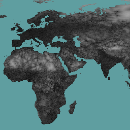
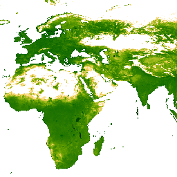
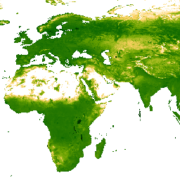
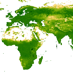
EVI: Malaria Atlas Project Gap-Filled Enhanced Vegetation Index (8-Daily 1km)
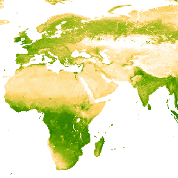
The underlying dataset for this Enhanced Vegetation Index (EVI) product is MODIS BRDF-corrected imagery (MCD43B4), which was gap-filled using the approach outlined in Weiss et al. (2014) to eliminate missing data caused by factors such as cloud cover. After gap-filling the data was clipped to … evi malariaatlasproject map publisher-dataset vegetation vegetation-indices -
EVI: Malaria Atlas Project Gap-Filled Enhanced Vegetation Index (Annual 1km)
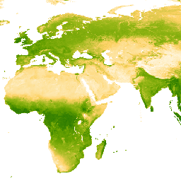
The underlying dataset for this Enhanced Vegetation Index (EVI) product is MODIS BRDF-corrected imagery (MCD43B4), which was gap-filled using the approach outlined in Weiss et al. (2014) to eliminate missing data caused by factors such as cloud cover. After gap-filling the data was clipped to … evi malariaatlasproject map publisher-dataset vegetation vegetation-indices -
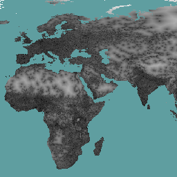
EVI: Malaria Atlas Project Gap-Filled Enhanced Vegetation Index (Monthly 1km)
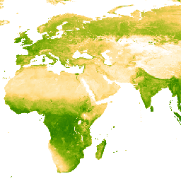
The underlying dataset for this Enhanced Vegetation Index (EVI) product is MODIS BRDF-corrected imagery (MCD43B4), which was gap-filled using the approach outlined in Weiss et al. (2014) to eliminate missing data caused by factors such as cloud cover. After gap-filling the data was clipped to … evi malariaatlasproject map publisher-dataset vegetation vegetation-indices -
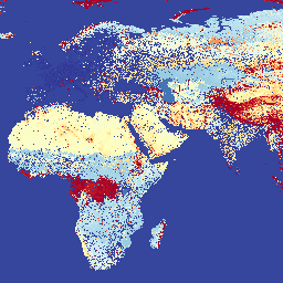
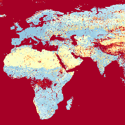
LST Day: Malaria Atlas Project Gap-Filled Daytime Land Surface Temperature (8-Daily 1km)
Daytime Land Surface Temperature (LST) are derived from the ~1km MODIS MOD11A2 v6.1 products. The 8-daily composites are converted to degrees Celsius and then gap-filled using the approach outlined in Weiss et al (2014) to eliminate missing data caused by factors such as cloud cover. … climate lst malariaatlasproject map publisher-dataset surface-temperature -
LST Day: Malaria Atlas Project Gap-Filled Daytime Land Surface Temperature (Annual 1km)

Daytime Land Surface Temperature (LST) are derived from the ~1km MODIS MOD11A2 v6.1 products. The 8-daily composites are converted to degrees Celsius and then gap-filled using the approach outlined in Weiss et al (2014) to eliminate missing data caused by factors such as cloud cover. … climate lst malariaatlasproject map publisher-dataset surface-temperature -
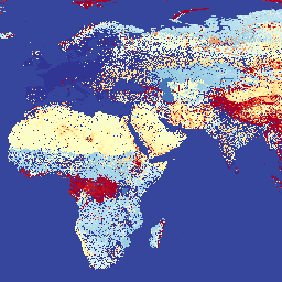
LST Day: Malaria Atlas Project Gap-Filled Daytime Land Surface Temperature (Monthly 1km)
Daytime Land Surface Temperature (LST) are derived from the ~1km MODIS MOD11A2 v6.1 products. The 8-daily composites are converted to degrees Celsius and then gap-filled using the approach outlined in Weiss et al (2014) to eliminate missing data caused by factors such as cloud cover. … climate lst malariaatlasproject map publisher-dataset surface-temperature -
LST Night: Malaria Atlas Project Gap-Filled Nighttime Land Surface Temperature (8-Daily 1km)
Nighttime Land Surface Temperature (LST) are derived from the ~1km MODIS MOD11A2 v6.1 products. The 8-daily composites are converted to degrees Celsius and then gap-filled using the approach outlined in Weiss et al (2014) to eliminate missing data caused by factors such as cloud cover. … climate lst malariaatlasproject map publisher-dataset surface-temperature -
LST Night: Malaria Atlas Project Gap-Filled Nighttime Land Surface Temperature (Annual 1km)
Nighttime Land Surface Temperature (LST) are derived from the ~1km MODIS MOD11A2 v6.1 products. The 8-daily composites are converted to degrees Celsius and then gap-filled using the approach outlined in Weiss et al (2014) to eliminate missing data caused by factors such as cloud cover. … climate lst malariaatlasproject map publisher-dataset surface-temperature -
LST Night: Malaria Atlas Project Gap-Filled Nighttime Land Surface Temperature (Monthly 1km)

Nighttime Land Surface Temperature (LST) are derived from the ~1km MODIS MOD11A2 v6.1 products. The 8-daily composites are converted to degrees Celsius and then gap-filled using the approach outlined in Weiss et al (2014) to eliminate missing data caused by factors such as cloud cover. … climate lst malariaatlasproject map publisher-dataset surface-temperature -
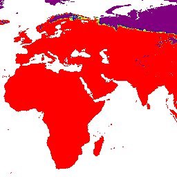
Malaria Atlas Project Accessibility to Cities 2015
This global accessibility map enumerates land-based travel time to the nearest densely-populated area for all areas between 85 degrees north and 60 degrees south for a nominal year 2015. Densely-populated areas are defined as contiguous areas with 1,500 or more inhabitants per square kilometer or … accessibility malariaatlasproject map population publisher-dataset -
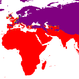
Malaria Atlas Project Accessibility to Healthcare 2019
This global accessibility map enumerates land-based travel time (in minutes) to the nearest hospital or clinic for all areas between 85 degrees north and 60 degrees south for a nominal year 2019. Major data collection efforts underway by OpenStreetMap, Google Maps, and academic researchers have … accessibility malariaatlasproject map population publisher-dataset -
Malaria Atlas Project Accessibility to Healthcare 2019 (Walking Only)
This global accessibility map enumerates land-based travel time (in minutes) to the nearest hospital or clinic for all areas between 85 degrees north and 60 degrees south for a nominal year 2019. This surface is based on "walking-only" travel time, using non-motorized means of transportation … accessibility malariaatlasproject map population publisher-dataset -
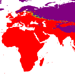
Malaria Atlas Project Global Friction Surface 2015
Friction Surface 2019". This global friction surface enumerates land-based travel speed for all land pixels between 85 degrees north and 60 degrees south for a nominal year 2015. This map was produced through a collaboration between the University of Oxford Malaria Atlas Project (MAP), Google, … accessibility malariaatlasproject map population publisher-dataset -
Malaria Atlas Project Global Friction Surface 2019
This global friction surface enumerates land-based travel speed for all land pixels between 85 degrees north and 60 degrees south for a nominal year 2019. This map was produced through a collaboration between MAP (University of Oxford), Telethon Kids Institute (Perth, Australia), Google, and the … accessibility malariaatlasproject map population publisher-dataset -
Malaria Atlas Project Global Friction Surface 2019 (Walking Only)
This global friction surface enumerates land-based travel speed for all land pixels between 85 degrees north and 60 degrees south for a nominal year 2019. This surface is based on "walking-only" travel speed, using non-motorized means of transportation only. This map was produced through a … accessibility malariaatlasproject map population publisher-dataset -
Overture Maps - Places: Place
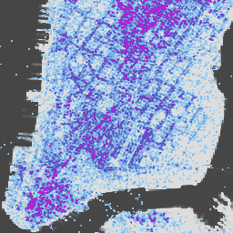
The Overture Maps Places theme contains more than 64 million point representations of real-world entities: businesses, schools, hospitals, religious organizations, landmarks, mountain peaks, and much more. Each place record includes location coordinates, names, categories, contact information (websites, social media, emails, phones), brand information, addresses, and … global infrastructure-boundaries map population publisher-dataset urban -
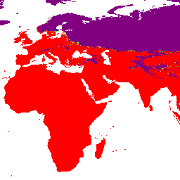
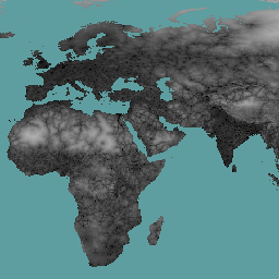
Oxford MAP: Malaria Atlas Project Fractional International Geosphere-Biosphere Programme Landcover

The underlying dataset for this landcover product is the IGBP layer found within the MODIS annual landcover product (MCD12Q1). This data was converted from its categorical format, which has a ≈500 meter resolution, to a fractional product indicating the integer percentage (0-100) of the output … landcover landuse-landcover map -
TCB: Malaria Atlas Project Gap-Filled Tasseled Cap Brightness (8-Daily 1km)
This gap-filled Tasseled Cap Brightness (TCB) dataset was created by applying the tasseled-cap equations defined in Lobser and Cohen (2007) to MODIS BRDF-corrected imagery (MCD43B4). The resulting data were gap-filled using the approach outlined in Weiss et al. (2014) to eliminate missing data caused by … brightness malariaatlasproject map publisher-dataset tasseled-cap tcb -
TCB: Malaria Atlas Project Gap-Filled Tasseled Cap Brightness (Annual 1km)
This gap-filled Tasseled Cap Brightness (TCB) dataset was created by applying the tasseled-cap equations defined in Lobser and Cohen (2007) to MODIS BRDF-corrected imagery (MCD43B4). The resulting data were gap-filled using the approach outlined in Weiss et al. (2014) to eliminate missing data caused by … brightness malariaatlasproject map publisher-dataset tasseled-cap tcb -
TCB: Malaria Atlas Project Gap-Filled Tasseled Cap Brightness (Monthly 1km)
This gap-filled Tasseled Cap Brightness (TCB) dataset was created by applying the tasseled-cap equations defined in Lobser and Cohen (2007) to MODIS BRDF-corrected imagery (MCD43B4). The resulting data were gap-filled using the approach outlined in Weiss et al. (2014) to eliminate missing data caused by … brightness malariaatlasproject map publisher-dataset tasseled-cap tcb -
TCW: Malaria Atlas Project Gap-Filled Tasseled Cap Wetness (8-Daily 1km)

This gap-filled Tasseled Cap Wetness (TCW) dataset was created by applying the tasseled-cap equations defined in Lobser and Cohen (2007) to MODIS BRDF-corrected imagery (MCD43B4). The resulting data were gap-filled using the approach outlined in Weiss et al. (2014) to eliminate missing data caused by … malariaatlasproject map publisher-dataset tasseled-cap tcw vegetation -
TCW: Malaria Atlas Project Gap-Filled Tasseled Cap Wetness (Annual 1km)
This gap-filled Tasseled Cap Wetness (TCW) dataset was created by applying the tasseled-cap equations defined in Lobser and Cohen (2007) to MODIS BRDF-corrected imagery (MCD43B4). The resulting data were gap-filled using the approach outlined in Weiss et al. (2014) to eliminate missing data caused by … malariaatlasproject map publisher-dataset tasseled-cap tcw vegetation -
TCW: Malaria Atlas Project Gap-Filled Tasseled Cap Wetness (Monthly 1km)
This gap-filled Tasseled Cap Wetness (TCW) dataset was created by applying the tasseled-cap equations defined in Lobser and Cohen (2007) to MODIS BRDF-corrected imagery (MCD43B4). The resulting data were gap-filled using the approach outlined in Weiss et al. (2014) to eliminate missing data caused by … malariaatlasproject map publisher-dataset tasseled-cap tcw vegetation