Page Summary
-
Global accessibility maps measure land-based travel time to cities and healthcare facilities.
-
The datasets cover areas between 85 degrees north and 60 degrees south.
-
Accessibility maps and friction surfaces are available for nominal years 2015 and 2019.
-
Some datasets include "walking-only" travel times or speeds.
-
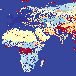
Malaria Atlas Project Accessibility to Cities 2015
This global accessibility map enumerates land-based travel time to the nearest densely-populated area for all areas between 85 degrees north and 60 degrees south for a nominal year 2015. Densely-populated areas are defined as contiguous areas with 1,500 or more inhabitants per square kilometer or … accessibility malariaatlasproject map population publisher-dataset -
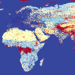
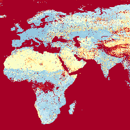
Malaria Atlas Project Accessibility to Healthcare 2019
This global accessibility map enumerates land-based travel time (in minutes) to the nearest hospital or clinic for all areas between 85 degrees north and 60 degrees south for a nominal year 2019. Major data collection efforts underway by OpenStreetMap, Google Maps, and academic researchers have … accessibility malariaatlasproject map population publisher-dataset -
Malaria Atlas Project Accessibility to Healthcare 2019 (Walking Only)
This global accessibility map enumerates land-based travel time (in minutes) to the nearest hospital or clinic for all areas between 85 degrees north and 60 degrees south for a nominal year 2019. This surface is based on "walking-only" travel time, using non-motorized means of transportation … accessibility malariaatlasproject map population publisher-dataset -
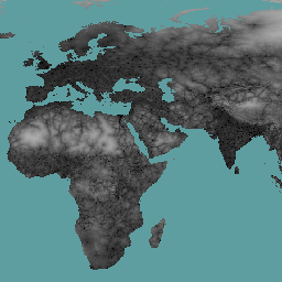
Malaria Atlas Project Global Friction Surface 2015
Friction Surface 2019". This global friction surface enumerates land-based travel speed for all land pixels between 85 degrees north and 60 degrees south for a nominal year 2015. This map was produced through a collaboration between the University of Oxford Malaria Atlas Project (MAP), Google, … accessibility malariaatlasproject map population publisher-dataset -
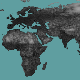
Malaria Atlas Project Global Friction Surface 2019
This global friction surface enumerates land-based travel speed for all land pixels between 85 degrees north and 60 degrees south for a nominal year 2019. This map was produced through a collaboration between MAP (University of Oxford), Telethon Kids Institute (Perth, Australia), Google, and the … accessibility malariaatlasproject map population publisher-dataset -
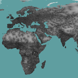
Malaria Atlas Project Global Friction Surface 2019 (Walking Only)
This global friction surface enumerates land-based travel speed for all land pixels between 85 degrees north and 60 degrees south for a nominal year 2019. This surface is based on "walking-only" travel speed, using non-motorized means of transportation only. This map was produced through a … accessibility malariaatlasproject map population publisher-dataset