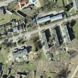
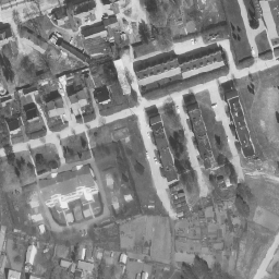
ऑर्थोफ़ोटो, एस्टोनिया को कवर करने वाला एरियल फ़ोटो डेटासेट है. ऑर्थोफ़ोटो, प्रोसेस की गई हवाई फ़ोटो होती है. इसमें, ज़मीन की ऊंचाई, एक्सपोज़र के समय ज़मीन के हिसाब से कैमरे के झुकाव, और कैमरे के सेंट्रल प्रोजेक्शन की वजह से होने वाली गड़बड़ियों को हटा दिया जाता है. डिजिटल ऑर्थोफ़ोटो में कुछ …
ऑर्थोफ़ोटो, एस्टोनिया को कवर करने वाला एरियल फ़ोटो डेटासेट है. ऑर्थोफ़ोटो, प्रोसेस की गई हवाई फ़ोटो होती है. इसमें, ज़मीन की ऊंचाई, एक्सपोज़र के समय ज़मीन के हिसाब से कैमरे के झुकाव, और कैमरे के सेंट्रल प्रोजेक्शन की वजह से होने वाली गड़बड़ियों को हटा दिया जाता है. डिजिटल ऑर्थोफ़ोटो में कुछ …
[[["समझने में आसान है","easyToUnderstand","thumb-up"],["मेरी समस्या हल हो गई","solvedMyProblem","thumb-up"],["अन्य","otherUp","thumb-up"]],[["वह जानकारी मौजूद नहीं है जो मुझे चाहिए","missingTheInformationINeed","thumb-down"],["बहुत मुश्किल है / बहुत सारे चरण हैं","tooComplicatedTooManySteps","thumb-down"],["पुराना","outOfDate","thumb-down"],["अनुवाद से जुड़ी समस्या","translationIssue","thumb-down"],["सैंपल / कोड से जुड़ी समस्या","samplesCodeIssue","thumb-down"],["अन्य","otherDown","thumb-down"]],[],[],["Estonia has aerial photo datasets called orthophotos. These are processed photos where distortions from terrain, camera tilt, and projection are removed. The datasets cover Estonia and are available in both monochrome and RGB formats. The photos were taken at low-flying altitudes. The datasets are referred to as Estonia mono low flying orthophotos and Estonia RGB low flying orthophotos.\n"]]