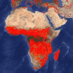
Earth Engine 버전의 Fire Information for Resource Management System (FIRMS) 데이터 세트에는 래스터화된 형식의 LANCE 화재 감지 제품이 포함되어 있습니다. 거의 실시간 (NRT) 활성 화재 위치는 표준 MODIS MOD14/MYD14 화재 및 열 이상 제품을 사용하여 LANCE에서 처리됩니다. 각 …
NOAA-20 (JPSS-1) 가시광선 적외선 이미징 방사계 (VIIRS) 활성 화재 감지 제품은 기기의 375m 공칭 해상도 데이터를 기반으로 합니다. 다른 더 낮은 해상도 (≥ 1km) 위성 화재 감지 제품과 비교할 때 개선된 375m 데이터는 비교적 작은 화재에 대해 더 큰 반응을 제공합니다.
Suomi NPP 가시광선 적외선 영상 방사계 (VIIRS) 활성 화재 감지 제품은 기기의 375m 공칭 해상도 데이터를 기반으로 합니다. 다른 더 낮은 해상도 (≥ 1km) 위성 화재 감지 제품과 비교할 때 개선된 375m 데이터는 비교적 작은 화재에 대해 더 큰 반응을 제공합니다.
[[["이해하기 쉬움","easyToUnderstand","thumb-up"],["문제가 해결됨","solvedMyProblem","thumb-up"],["기타","otherUp","thumb-up"]],[["필요한 정보가 없음","missingTheInformationINeed","thumb-down"],["너무 복잡함/단계 수가 너무 많음","tooComplicatedTooManySteps","thumb-down"],["오래됨","outOfDate","thumb-down"],["번역 문제","translationIssue","thumb-down"],["샘플/코드 문제","samplesCodeIssue","thumb-down"],["기타","otherDown","thumb-down"]],[],[],["The Fire Information for Resource Management System (FIRMS) dataset uses LANCE to process near real-time active fire locations from MODIS data. Additionally, VIIRS active fire detection products from NOAA-20 and Suomi NPP are available, both using 375m resolution data. This resolution provides better detection of smaller fires than the coarser resolution (≥ 1km) data.\n"]]