-
BLM AIM TerrADat TerrestrialAIM Point v1
ตั้งแต่ปี 2011 สำนักงานจัดการที่ดิน (Bureau of Land Management หรือ BLM) ได้รวบรวมข้อมูลภาคสนามเพื่อแจ้งให้ทราบถึงสุขภาพของที่ดินผ่านกลยุทธ์การประเมินสินค้าคงคลังและการตรวจสอบ (Assessment Inventory and Monitoring หรือ AIM) จนถึงปัจจุบัน มีการเก็บรวบรวมแปลงทดสอบภาคสนามของ AIM บนบกมากกว่า 6,000 แปลงในพื้นที่ของ BLM ที่เก็บถาวรข้อมูล BLM AIM คือ … blm ecosystems hydrology range soil table -
ชุดข้อมูล GLOBathy Global lakes bathymetry

ชุดข้อมูลความลึกของน้ำทั่วโลก (GLOBathy) ซึ่งประกอบด้วยข้อมูลเกี่ยวกับแหล่งน้ำกว่า 1.4 ล้านแห่งทั่วโลกได้รับการพัฒนาอย่างพิถีพิถันเพื่อให้สอดคล้องกับชุดข้อมูล HydroLAKES ที่ได้รับการยอมรับอย่างกว้างขวาง GLOBathy ใช้ประโยชน์จากเฟรมเวิร์กที่ซับซ้อนซึ่งอิงตามระบบสารสนเทศภูมิศาสตร์ (GIS) ในการสร้างแผนที่ภูมิประเทศใต้น้ำแบบละเอียดโดยการผสานรวมค่าประมาณความลึกสูงสุดและข้อมูลทางเรขาคณิต/ธรณีฟิสิกส์ … bathymetry community-dataset hydrology sat-io surface-ground-water -
HUC02: ชุดข้อมูลขอบเขตลุ่มน้ำของ USGS ของภูมิภาค

ชุดข้อมูลขอบเขตลุ่มน้ำ (WBD) เป็นคอลเล็กชันข้อมูลหน่วยอุทกวิทยา (HU) แบบรวมที่ครอบคลุมซึ่งสอดคล้องกับเกณฑ์ระดับประเทศสำหรับการกำหนดขอบเขตและความละเอียด โดยจะกำหนดขอบเขตพื้นที่ของการระบายน้ำผิวดินไปยังจุดหนึ่ง ยกเว้นในพื้นที่ชายฝั่งหรือริมทะเลสาบที่ … อุทกวิทยา น้ำผิวดินและน้ำใต้ดิน ตาราง usgs น้ำ ลุ่มน้ำ -
HUC04: ชุดข้อมูลขอบเขตลุ่มน้ำของ USGS ของภูมิภาคย่อย

ชุดข้อมูลขอบเขตลุ่มน้ำ (WBD) เป็นคอลเล็กชันข้อมูลหน่วยอุทกวิทยา (HU) แบบรวมที่ครอบคลุมซึ่งสอดคล้องกับเกณฑ์ระดับประเทศสำหรับการกำหนดขอบเขตและความละเอียด โดยจะกำหนดขอบเขตพื้นที่ของการระบายน้ำผิวดินไปยังจุดหนึ่ง ยกเว้นในพื้นที่ชายฝั่งหรือริมทะเลสาบที่ … อุทกวิทยา น้ำผิวดินและน้ำใต้ดิน ตาราง usgs น้ำ ลุ่มน้ำ -
HUC06: ชุดข้อมูลขอบเขตลุ่มน้ำของ USGS ของลุ่มน้ำ

ชุดข้อมูลขอบเขตลุ่มน้ำ (WBD) เป็นคอลเล็กชันข้อมูลหน่วยอุทกวิทยา (HU) แบบรวมที่ครอบคลุมซึ่งสอดคล้องกับเกณฑ์ระดับประเทศสำหรับการกำหนดขอบเขตและความละเอียด โดยจะกำหนดขอบเขตพื้นที่ของการระบายน้ำผิวดินไปยังจุดหนึ่ง ยกเว้นในพื้นที่ชายฝั่งหรือริมทะเลสาบที่ … อุทกวิทยา น้ำผิวดินและน้ำใต้ดิน ตาราง usgs น้ำ ลุ่มน้ำ -
HUC08: ชุดข้อมูลขอบเขตลุ่มน้ำของ USGS ของลุ่มน้ำย่อย

ชุดข้อมูลขอบเขตลุ่มน้ำ (WBD) เป็นคอลเล็กชันข้อมูลหน่วยอุทกวิทยา (HU) แบบรวมที่ครอบคลุมซึ่งสอดคล้องกับเกณฑ์ระดับประเทศสำหรับการกำหนดขอบเขตและความละเอียด โดยจะกำหนดขอบเขตพื้นที่ของการระบายน้ำผิวดินไปยังจุดหนึ่ง ยกเว้นในพื้นที่ชายฝั่งหรือริมทะเลสาบที่ … อุทกวิทยา น้ำผิวดินและน้ำใต้ดิน ตาราง usgs น้ำ ลุ่มน้ำ -
HUC10: ชุดข้อมูลขอบเขตลุ่มน้ำของ USGS

ชุดข้อมูลขอบเขตลุ่มน้ำ (WBD) เป็นคอลเล็กชันข้อมูลหน่วยอุทกวิทยา (HU) แบบรวมที่ครอบคลุมซึ่งสอดคล้องกับเกณฑ์ระดับประเทศสำหรับการกำหนดขอบเขตและความละเอียด โดยจะกำหนดขอบเขตพื้นที่ของการระบายน้ำผิวดินไปยังจุดหนึ่ง ยกเว้นในพื้นที่ชายฝั่งหรือริมทะเลสาบที่ … อุทกวิทยา น้ำผิวดินและน้ำใต้ดิน ตาราง usgs น้ำ ลุ่มน้ำ -
HUC12: ชุดข้อมูลขอบเขตลุ่มน้ำของ USGS ของลุ่มน้ำย่อย
ชุดข้อมูลขอบเขตลุ่มน้ำ (WBD) เป็นคอลเล็กชันข้อมูลหน่วยอุทกวิทยา (HU) แบบรวมที่ครอบคลุมซึ่งสอดคล้องกับเกณฑ์ระดับประเทศสำหรับการกำหนดขอบเขตและความละเอียด โดยจะกำหนดขอบเขตพื้นที่ของการระบายน้ำผิวดินไปยังจุดหนึ่ง ยกเว้นในพื้นที่ชายฝั่งหรือริมทะเลสาบที่ … อุทกวิทยา น้ำผิวดินและน้ำใต้ดิน ตาราง usgs น้ำ ลุ่มน้ำ -
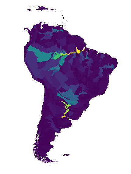
ลุ่มน้ำ WWF HydroATLAS ระดับ 03
BasinATLAS เป็นคอมโพเนนต์ของฐานข้อมูล HydroATLAS ซึ่งเป็นคอมโพเนนต์ของ HydroSHEDS BasinATLAS เป็นแหล่งข้อมูลที่ได้มาตรฐานเกี่ยวกับคุณลักษณะด้านอุทกวิทยาและสิ่งแวดล้อมสำหรับลุ่มน้ำทั้งหมดทั่วโลกที่ความละเอียดเชิงพื้นที่สูง ชุดข้อมูลนี้มีข้อมูลสำหรับตัวแปร 56 รายการ ซึ่งแบ่งออกเป็นแอตทริบิวต์ 281 รายการและ … geophysical hydroatlas hydrography hydrology hydrosheds srtm -
ลุ่มน้ำ WWF HydroATLAS ระดับ 04
BasinATLAS เป็นคอมโพเนนต์ของฐานข้อมูล HydroATLAS ซึ่งเป็นคอมโพเนนต์ของ HydroSHEDS BasinATLAS เป็นแหล่งข้อมูลที่ได้มาตรฐานเกี่ยวกับคุณลักษณะด้านอุทกวิทยาและสิ่งแวดล้อมสำหรับลุ่มน้ำทั้งหมดทั่วโลกที่ความละเอียดเชิงพื้นที่สูง ชุดข้อมูลนี้มีข้อมูลสำหรับตัวแปร 56 รายการ ซึ่งแบ่งออกเป็นแอตทริบิวต์ 281 รายการและ … geophysical hydroatlas hydrography hydrology hydrosheds srtm -
WWF HydroATLAS Basins ระดับ 05
BasinATLAS เป็นคอมโพเนนต์ของฐานข้อมูล HydroATLAS ซึ่งเป็นคอมโพเนนต์ของ HydroSHEDS BasinATLAS เป็นแหล่งข้อมูลที่ได้มาตรฐานเกี่ยวกับคุณลักษณะด้านอุทกวิทยาและสิ่งแวดล้อมสำหรับลุ่มน้ำทั้งหมดทั่วโลกที่ความละเอียดเชิงพื้นที่สูง ชุดข้อมูลนี้มีข้อมูลสำหรับตัวแปร 56 รายการ ซึ่งแบ่งออกเป็นแอตทริบิวต์ 281 รายการและ … geophysical hydroatlas hydrography hydrology hydrosheds srtm -
WWF HydroATLAS Basins ระดับ 06
BasinATLAS เป็นคอมโพเนนต์ของฐานข้อมูล HydroATLAS ซึ่งเป็นคอมโพเนนต์ของ HydroSHEDS BasinATLAS เป็นแหล่งข้อมูลที่ได้มาตรฐานเกี่ยวกับคุณลักษณะด้านอุทกวิทยาและสิ่งแวดล้อมสำหรับลุ่มน้ำทั้งหมดทั่วโลกที่ความละเอียดเชิงพื้นที่สูง ชุดข้อมูลนี้มีข้อมูลสำหรับตัวแปร 56 รายการ ซึ่งแบ่งออกเป็นแอตทริบิวต์ 281 รายการและ … geophysical hydroatlas hydrography hydrology hydrosheds srtm -
ลุ่มน้ำ WWF HydroATLAS ระดับ 07
BasinATLAS เป็นคอมโพเนนต์ของฐานข้อมูล HydroATLAS ซึ่งเป็นคอมโพเนนต์ของ HydroSHEDS BasinATLAS เป็นแหล่งข้อมูลที่ได้มาตรฐานเกี่ยวกับคุณลักษณะด้านอุทกวิทยาและสิ่งแวดล้อมสำหรับลุ่มน้ำทั้งหมดทั่วโลกที่ความละเอียดเชิงพื้นที่สูง ชุดข้อมูลนี้มีข้อมูลสำหรับตัวแปร 56 รายการ ซึ่งแบ่งออกเป็นแอตทริบิวต์ 281 รายการและ … geophysical hydroatlas hydrography hydrology hydrosheds srtm -
ลุ่มน้ำ WWF HydroATLAS ระดับ 08
BasinATLAS เป็นคอมโพเนนต์ของฐานข้อมูล HydroATLAS ซึ่งเป็นคอมโพเนนต์ของ HydroSHEDS BasinATLAS เป็นแหล่งข้อมูลที่ได้มาตรฐานเกี่ยวกับคุณลักษณะด้านอุทกวิทยาและสิ่งแวดล้อมสำหรับลุ่มน้ำทั้งหมดทั่วโลกที่ความละเอียดเชิงพื้นที่สูง ชุดข้อมูลนี้มีข้อมูลสำหรับตัวแปร 56 รายการ ซึ่งแบ่งออกเป็นแอตทริบิวต์ 281 รายการและ … geophysical hydroatlas hydrography hydrology hydrosheds srtm -
WWF HydroATLAS Basins ระดับ 09
BasinATLAS เป็นคอมโพเนนต์ของฐานข้อมูล HydroATLAS ซึ่งเป็นคอมโพเนนต์ของ HydroSHEDS BasinATLAS เป็นแหล่งข้อมูลที่ได้มาตรฐานเกี่ยวกับคุณลักษณะด้านอุทกวิทยาและสิ่งแวดล้อมสำหรับลุ่มน้ำทั้งหมดทั่วโลกที่ความละเอียดเชิงพื้นที่สูง ชุดข้อมูลนี้มีข้อมูลสำหรับตัวแปร 56 รายการ ซึ่งแบ่งออกเป็นแอตทริบิวต์ 281 รายการและ … geophysical hydroatlas hydrography hydrology hydrosheds srtm -
ลุ่มน้ำระดับ 10 ของ WWF HydroATLAS
BasinATLAS เป็นคอมโพเนนต์ของฐานข้อมูล HydroATLAS ซึ่งเป็นคอมโพเนนต์ของ HydroSHEDS BasinATLAS เป็นแหล่งข้อมูลที่ได้มาตรฐานเกี่ยวกับคุณลักษณะด้านอุทกวิทยาและสิ่งแวดล้อมสำหรับลุ่มน้ำทั้งหมดทั่วโลกที่ความละเอียดเชิงพื้นที่สูง ชุดข้อมูลนี้มีข้อมูลสำหรับตัวแปร 56 รายการ ซึ่งแบ่งออกเป็นแอตทริบิวต์ 281 รายการและ … geophysical hydroatlas hydrography hydrology hydrosheds srtm -
ลุ่มน้ำ WWF HydroATLAS ระดับ 11

BasinATLAS เป็นคอมโพเนนต์ของฐานข้อมูล HydroATLAS ซึ่งเป็นคอมโพเนนต์ของ HydroSHEDS BasinATLAS เป็นแหล่งข้อมูลที่ได้มาตรฐานเกี่ยวกับคุณลักษณะด้านอุทกวิทยาและสิ่งแวดล้อมสำหรับลุ่มน้ำทั้งหมดทั่วโลกที่ความละเอียดเชิงพื้นที่สูง ชุดข้อมูลนี้มีข้อมูลสำหรับตัวแปร 56 รายการ ซึ่งแบ่งออกเป็นแอตทริบิวต์ 281 รายการและ … geophysical hydroatlas hydrography hydrology hydrosheds srtm -
ลุ่มน้ำ WWF HydroATLAS ระดับ 12
BasinATLAS เป็นคอมโพเนนต์ของฐานข้อมูล HydroATLAS ซึ่งเป็นคอมโพเนนต์ของ HydroSHEDS BasinATLAS เป็นแหล่งข้อมูลที่ได้มาตรฐานเกี่ยวกับคุณลักษณะด้านอุทกวิทยาและสิ่งแวดล้อมสำหรับลุ่มน้ำทั้งหมดทั่วโลกที่ความละเอียดเชิงพื้นที่สูง ชุดข้อมูลนี้มีข้อมูลสำหรับตัวแปร 56 รายการ ซึ่งแบ่งออกเป็นแอตทริบิวต์ 281 รายการและ … geophysical hydroatlas hydrography hydrology hydrosheds srtm -
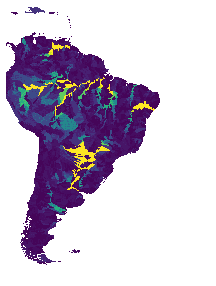
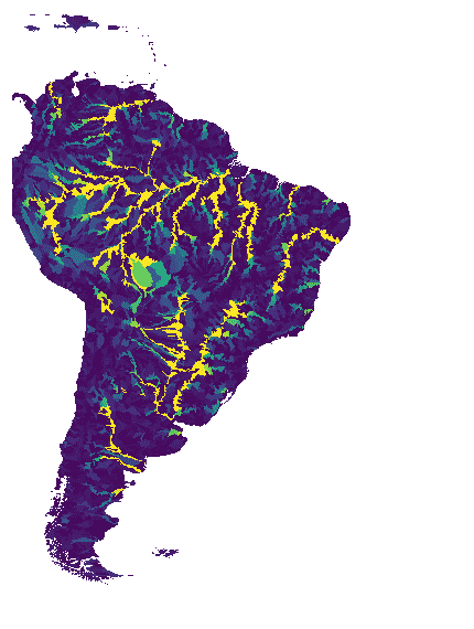
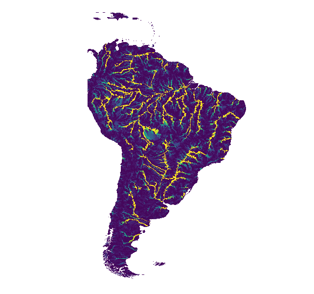
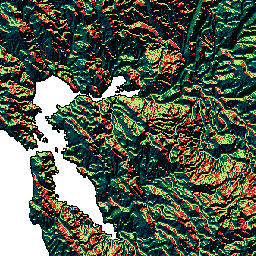
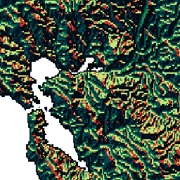
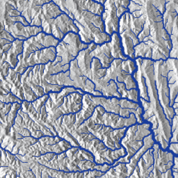
ลุ่มน้ำ WWF HydroSHEDS ระดับ 1

HydroSHEDS เป็นผลิตภัณฑ์การทำแผนที่ที่ให้ข้อมูลอุทกศาสตร์สำหรับการใช้งานระดับภูมิภาคและระดับโลกในรูปแบบที่สอดคล้องกัน โดยมีชุดข้อมูลที่อ้างอิงทางภูมิศาสตร์ (เวกเตอร์และแรสเตอร์) ในระดับต่างๆ ซึ่งรวมถึงเครือข่ายแม่น้ำ ขอบเขตลุ่มน้ำ ทิศทางการระบายน้ำ และการสะสมการไหล HydroSHEDS อิงตาม … geophysical hydrography hydrology hydrosheds srtm surface-ground-water -
ลุ่มน้ำ WWF HydroSHEDS ระดับ 10
HydroSHEDS เป็นผลิตภัณฑ์การทำแผนที่ที่ให้ข้อมูลอุทกศาสตร์สำหรับการใช้งานระดับภูมิภาคและระดับโลกในรูปแบบที่สอดคล้องกัน โดยมีชุดข้อมูลที่อ้างอิงทางภูมิศาสตร์ (เวกเตอร์และแรสเตอร์) ในระดับต่างๆ ซึ่งรวมถึงเครือข่ายแม่น้ำ ขอบเขตลุ่มน้ำ ทิศทางการระบายน้ำ และการสะสมการไหล HydroSHEDS อิงตาม … geophysical hydrography hydrology hydrosheds srtm surface-ground-water -
WWF HydroSHEDS Basins ระดับ 11

HydroSHEDS เป็นผลิตภัณฑ์การทำแผนที่ที่ให้ข้อมูลอุทกศาสตร์สำหรับการใช้งานระดับภูมิภาคและระดับโลกในรูปแบบที่สอดคล้องกัน โดยมีชุดข้อมูลที่อ้างอิงทางภูมิศาสตร์ (เวกเตอร์และแรสเตอร์) ในระดับต่างๆ ซึ่งรวมถึงเครือข่ายแม่น้ำ ขอบเขตลุ่มน้ำ ทิศทางการระบายน้ำ และการสะสมการไหล HydroSHEDS อิงตาม … geophysical hydrography hydrology hydrosheds srtm surface-ground-water -
ลุ่มน้ำ WWF HydroSHEDS ระดับ 12

HydroSHEDS เป็นผลิตภัณฑ์การทำแผนที่ที่ให้ข้อมูลอุทกศาสตร์สำหรับการใช้งานระดับภูมิภาคและระดับโลกในรูปแบบที่สอดคล้องกัน โดยมีชุดข้อมูลที่อ้างอิงทางภูมิศาสตร์ (เวกเตอร์และแรสเตอร์) ในระดับต่างๆ ซึ่งรวมถึงเครือข่ายแม่น้ำ ขอบเขตลุ่มน้ำ ทิศทางการระบายน้ำ และการสะสมการไหล HydroSHEDS อิงตาม … geophysical hydrography hydrology hydrosheds srtm surface-ground-water -
ลุ่มน้ำ WWF HydroSHEDS ระดับ 2

HydroSHEDS เป็นผลิตภัณฑ์การทำแผนที่ที่ให้ข้อมูลอุทกศาสตร์สำหรับการใช้งานระดับภูมิภาคและระดับโลกในรูปแบบที่สอดคล้องกัน โดยมีชุดข้อมูลที่อ้างอิงทางภูมิศาสตร์ (เวกเตอร์และแรสเตอร์) ในระดับต่างๆ ซึ่งรวมถึงเครือข่ายแม่น้ำ ขอบเขตลุ่มน้ำ ทิศทางการระบายน้ำ และการสะสมการไหล HydroSHEDS อิงตาม … geophysical hydrography hydrology hydrosheds srtm surface-ground-water -
ลุ่มน้ำ WWF HydroSHEDS ระดับ 3

HydroSHEDS เป็นผลิตภัณฑ์การทำแผนที่ที่ให้ข้อมูลอุทกศาสตร์สำหรับการใช้งานระดับภูมิภาคและระดับโลกในรูปแบบที่สอดคล้องกัน โดยมีชุดข้อมูลที่อ้างอิงทางภูมิศาสตร์ (เวกเตอร์และแรสเตอร์) ในระดับต่างๆ ซึ่งรวมถึงเครือข่ายแม่น้ำ ขอบเขตลุ่มน้ำ ทิศทางการระบายน้ำ และการสะสมการไหล HydroSHEDS อิงตาม … geophysical hydrography hydrology hydrosheds srtm surface-ground-water -
ลุ่มน้ำ WWF HydroSHEDS ระดับ 4

HydroSHEDS เป็นผลิตภัณฑ์การทำแผนที่ที่ให้ข้อมูลอุทกศาสตร์สำหรับการใช้งานระดับภูมิภาคและระดับโลกในรูปแบบที่สอดคล้องกัน โดยมีชุดข้อมูลที่อ้างอิงทางภูมิศาสตร์ (เวกเตอร์และแรสเตอร์) ในระดับต่างๆ ซึ่งรวมถึงเครือข่ายแม่น้ำ ขอบเขตลุ่มน้ำ ทิศทางการระบายน้ำ และการสะสมการไหล HydroSHEDS อิงตาม … geophysical hydrography hydrology hydrosheds srtm surface-ground-water -
ลุ่มน้ำ WWF HydroSHEDS ระดับ 5

HydroSHEDS เป็นผลิตภัณฑ์การทำแผนที่ที่ให้ข้อมูลอุทกศาสตร์สำหรับการใช้งานระดับภูมิภาคและระดับโลกในรูปแบบที่สอดคล้องกัน โดยมีชุดข้อมูลที่อ้างอิงทางภูมิศาสตร์ (เวกเตอร์และแรสเตอร์) ในระดับต่างๆ ซึ่งรวมถึงเครือข่ายแม่น้ำ ขอบเขตลุ่มน้ำ ทิศทางการระบายน้ำ และการสะสมการไหล HydroSHEDS อิงตาม … geophysical hydrography hydrology hydrosheds srtm surface-ground-water -
ลุ่มน้ำ WWF HydroSHEDS ระดับ 6

HydroSHEDS เป็นผลิตภัณฑ์การทำแผนที่ที่ให้ข้อมูลอุทกศาสตร์สำหรับการใช้งานระดับภูมิภาคและระดับโลกในรูปแบบที่สอดคล้องกัน โดยมีชุดข้อมูลที่อ้างอิงทางภูมิศาสตร์ (เวกเตอร์และแรสเตอร์) ในระดับต่างๆ ซึ่งรวมถึงเครือข่ายแม่น้ำ ขอบเขตลุ่มน้ำ ทิศทางการระบายน้ำ และการสะสมการไหล HydroSHEDS อิงตาม … geophysical hydrography hydrology hydrosheds srtm surface-ground-water -
ลุ่มน้ำ WWF HydroSHEDS ระดับ 7

HydroSHEDS เป็นผลิตภัณฑ์การทำแผนที่ที่ให้ข้อมูลอุทกศาสตร์สำหรับการใช้งานระดับภูมิภาคและระดับโลกในรูปแบบที่สอดคล้องกัน โดยมีชุดข้อมูลที่อ้างอิงทางภูมิศาสตร์ (เวกเตอร์และแรสเตอร์) ในระดับต่างๆ ซึ่งรวมถึงเครือข่ายแม่น้ำ ขอบเขตลุ่มน้ำ ทิศทางการระบายน้ำ และการสะสมการไหล HydroSHEDS อิงตาม … geophysical hydrography hydrology hydrosheds srtm surface-ground-water -
ลุ่มน้ำ WWF HydroSHEDS ระดับ 8

HydroSHEDS เป็นผลิตภัณฑ์การทำแผนที่ที่ให้ข้อมูลอุทกศาสตร์สำหรับการใช้งานระดับภูมิภาคและระดับโลกในรูปแบบที่สอดคล้องกัน โดยมีชุดข้อมูลที่อ้างอิงทางภูมิศาสตร์ (เวกเตอร์และแรสเตอร์) ในระดับต่างๆ ซึ่งรวมถึงเครือข่ายแม่น้ำ ขอบเขตลุ่มน้ำ ทิศทางการระบายน้ำ และการสะสมการไหล HydroSHEDS อิงตาม … geophysical hydrography hydrology hydrosheds srtm surface-ground-water -
ลุ่มน้ำ WWF HydroSHEDS ระดับ 9

HydroSHEDS เป็นผลิตภัณฑ์การทำแผนที่ที่ให้ข้อมูลอุทกศาสตร์สำหรับการใช้งานระดับภูมิภาคและระดับโลกในรูปแบบที่สอดคล้องกัน โดยมีชุดข้อมูลที่อ้างอิงทางภูมิศาสตร์ (เวกเตอร์และแรสเตอร์) ในระดับต่างๆ ซึ่งรวมถึงเครือข่ายแม่น้ำ ขอบเขตลุ่มน้ำ ทิศทางการระบายน้ำ และการสะสมการไหล HydroSHEDS อิงตาม … geophysical hydrography hydrology hydrosheds srtm surface-ground-water -
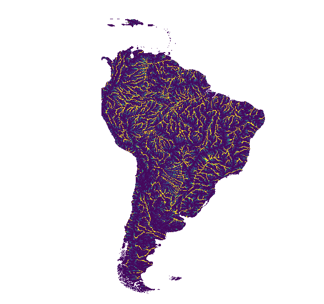
ทิศทางการระบายน้ำของ WWF HydroSHEDS, 15 อาร์คเซค
HydroSHEDS เป็นผลิตภัณฑ์การทำแผนที่ที่ให้ข้อมูลอุทกศาสตร์สำหรับการใช้งานระดับภูมิภาคและระดับโลกในรูปแบบที่สอดคล้องกัน โดยมีชุดข้อมูลที่อ้างอิงทางภูมิศาสตร์ (เวกเตอร์และแรสเตอร์) ในระดับต่างๆ ซึ่งรวมถึงเครือข่ายแม่น้ำ ขอบเขตลุ่มน้ำ ทิศทางการระบายน้ำ และการสะสมการไหล HydroSHEDS อิงตาม … direction drainage flow geophysical hydrography hydrology -
ทิศทางการระบายน้ำของ WWF HydroSHEDS, 3 อาร์คเซค
HydroSHEDS เป็นผลิตภัณฑ์การทำแผนที่ที่ให้ข้อมูลอุทกศาสตร์สำหรับการใช้งานระดับภูมิภาคและระดับโลกในรูปแบบที่สอดคล้องกัน โดยมีชุดข้อมูลที่อ้างอิงทางภูมิศาสตร์ (เวกเตอร์และแรสเตอร์) ในระดับต่างๆ ซึ่งรวมถึงเครือข่ายแม่น้ำ ขอบเขตลุ่มน้ำ ทิศทางการระบายน้ำ และการสะสมการไหล HydroSHEDS อิงตาม … direction drainage flow geophysical hydrography hydrology -
ทิศทางการระบายน้ำของ WWF HydroSHEDS, 30 อาร์คเซค
HydroSHEDS เป็นผลิตภัณฑ์การทำแผนที่ที่ให้ข้อมูลอุทกศาสตร์สำหรับการใช้งานระดับภูมิภาคและระดับโลกในรูปแบบที่สอดคล้องกัน โดยมีชุดข้อมูลที่อ้างอิงทางภูมิศาสตร์ (เวกเตอร์และแรสเตอร์) ในระดับต่างๆ ซึ่งรวมถึงเครือข่ายแม่น้ำ ขอบเขตลุ่มน้ำ ทิศทางการระบายน้ำ และการสะสมการไหล HydroSHEDS อิงตาม … direction drainage flow geophysical hydrography hydrology -
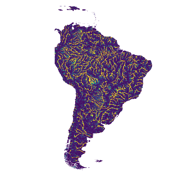
การสะสมการไหลของ WWF HydroSHEDS, 15 อาร์คเซค
HydroSHEDS เป็นผลิตภัณฑ์การทำแผนที่ที่ให้ข้อมูลอุทกศาสตร์สำหรับการใช้งานระดับภูมิภาคและระดับโลกในรูปแบบที่สอดคล้องกัน โดยมีชุดข้อมูลที่อ้างอิงทางภูมิศาสตร์ (เวกเตอร์และแรสเตอร์) ในระดับต่างๆ ซึ่งรวมถึงเครือข่ายแม่น้ำ ขอบเขตลุ่มน้ำ ทิศทางการระบายน้ำ และการสะสมการไหล HydroSHEDS อิงตาม … การสะสม การระบายน้ำ การไหล ธรณีฟิสิกส์ อุทกศาสตร์ อุทกวิทยา -
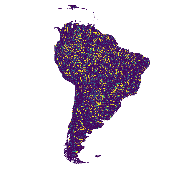
การสะสมการไหลของ WWF HydroSHEDS, 30 อาร์คเซก
HydroSHEDS เป็นผลิตภัณฑ์การทำแผนที่ที่ให้ข้อมูลอุทกศาสตร์สำหรับการใช้งานระดับภูมิภาคและระดับโลกในรูปแบบที่สอดคล้องกัน โดยมีชุดข้อมูลที่อ้างอิงทางภูมิศาสตร์ (เวกเตอร์และแรสเตอร์) ในระดับต่างๆ ซึ่งรวมถึงเครือข่ายแม่น้ำ ขอบเขตลุ่มน้ำ ทิศทางการระบายน้ำ และการสะสมการไหล HydroSHEDS อิงตาม … การสะสม การระบายน้ำ การไหล ธรณีฟิสิกส์ อุทกศาสตร์ อุทกวิทยา -
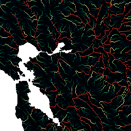
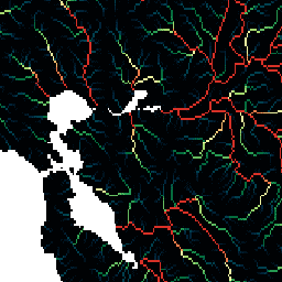
เครือข่ายแม่น้ำที่ไหลอย่างอิสระของ WWF HydroSHEDS v1
HydroSHEDS เป็นผลิตภัณฑ์การทำแผนที่ที่ให้ข้อมูลอุทกศาสตร์สำหรับการใช้งานระดับภูมิภาคและระดับโลกในรูปแบบที่สอดคล้องกัน โดยมีชุดข้อมูลที่อ้างอิงทางภูมิศาสตร์ (เวกเตอร์และแรสเตอร์) ในระดับต่างๆ ซึ่งรวมถึงเครือข่ายแม่น้ำ ขอบเขตลุ่มน้ำ ทิศทางการระบายน้ำ และการสะสมการไหล HydroSHEDS อิงตาม … geophysical hydrography hydrology hydrosheds srtm surface-ground-water -
DEM ที่ปรับสภาพทางอุทกวิทยาของ WWF HydroSHEDS, 15 อาร์คเซค
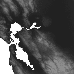
HydroSHEDS เป็นผลิตภัณฑ์การทำแผนที่ที่ให้ข้อมูลอุทกศาสตร์สำหรับการใช้งานระดับภูมิภาคและระดับโลกในรูปแบบที่สอดคล้องกัน โดยมีชุดข้อมูลที่อ้างอิงทางภูมิศาสตร์ (เวกเตอร์และแรสเตอร์) ในระดับต่างๆ ซึ่งรวมถึงเครือข่ายแม่น้ำ ขอบเขตลุ่มน้ำ ทิศทางการระบายน้ำ และการสะสมการไหล HydroSHEDS อิงตาม … ปรับสภาพ dem elevation geophysical hydrography hydrology -
DEM ที่ปรับสภาพทางอุทกวิทยาของ WWF HydroSHEDS, 3 อาร์ควินาที
HydroSHEDS เป็นผลิตภัณฑ์การทำแผนที่ที่ให้ข้อมูลอุทกศาสตร์สำหรับการใช้งานระดับภูมิภาคและระดับโลกในรูปแบบที่สอดคล้องกัน โดยมีชุดข้อมูลที่อ้างอิงทางภูมิศาสตร์ (เวกเตอร์และแรสเตอร์) ในระดับต่างๆ ซึ่งรวมถึงเครือข่ายแม่น้ำ ขอบเขตลุ่มน้ำ ทิศทางการระบายน้ำ และการสะสมการไหล HydroSHEDS อิงตาม … ปรับสภาพ dem elevation geophysical hydrography hydrology -
WWF HydroSHEDS Hydrologically Conditioned DEM, 30 Arc-Seconds
HydroSHEDS เป็นผลิตภัณฑ์การทำแผนที่ที่ให้ข้อมูลอุทกศาสตร์สำหรับการใช้งานระดับภูมิภาคและระดับโลกในรูปแบบที่สอดคล้องกัน โดยมีชุดข้อมูลที่อ้างอิงทางภูมิศาสตร์ (เวกเตอร์และแรสเตอร์) ในระดับต่างๆ ซึ่งรวมถึงเครือข่ายแม่น้ำ ขอบเขตลุ่มน้ำ ทิศทางการระบายน้ำ และการสะสมการไหล HydroSHEDS อิงตาม … ปรับสภาพ dem elevation geophysical hydrography hydrology -
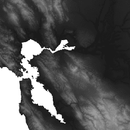
DEM ที่เติมช่องว่างของ WWF HydroSHEDS, 3 อาร์ควินาที
HydroSHEDS เป็นผลิตภัณฑ์การทำแผนที่ที่ให้ข้อมูลอุทกศาสตร์สำหรับการใช้งานระดับภูมิภาคและระดับโลกในรูปแบบที่สอดคล้องกัน โดยมีชุดข้อมูลที่อ้างอิงทางภูมิศาสตร์ (เวกเตอร์และแรสเตอร์) ในระดับต่างๆ ซึ่งรวมถึงเครือข่ายแม่น้ำ ขอบเขตลุ่มน้ำ ทิศทางการระบายน้ำ และการสะสมการไหล HydroSHEDS อิงตาม … dem ระดับความสูง geophysical hydrography hydrology hydrosheds