Page Summary
-
The Hybrid Coordinate Ocean Model (HYCOM) is a data-assimilative hybrid ocean model.
-
HYCOM data hosted in EE includes variables such as salinity, temperature, velocity, and elevation.
-
The HYCOM data is interpolated to a uniform 0.08 degree lat/long grid.
-
HYCOM: Hybrid Coordinate Ocean Model, Sea Surface Elevation
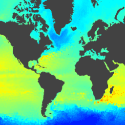
The Hybrid Coordinate Ocean Model (HYCOM) is a data-assimilative hybrid isopycnal-sigma-pressure (generalized) coordinate ocean model. The subset of HYCOM data hosted in EE contains the variables salinity, temperature, velocity, and elevation. They have been interpolated to a uniform 0.08 degree lat/long grid between 80.48°S and … elevation hycom nopp oceans water -
HYCOM: Hybrid Coordinate Ocean Model, Water Temperature and Salinity
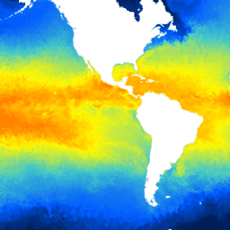
The Hybrid Coordinate Ocean Model (HYCOM) is a data-assimilative hybrid isopycnal-sigma-pressure (generalized) coordinate ocean model. The subset of HYCOM data hosted in EE contains the variables salinity, temperature, velocity, and elevation. They have been interpolated to a uniform 0.08 degree lat/long grid between 80.48°S and … hycom nopp oceans sst water -
HYCOM: Hybrid Coordinate Ocean Model, Water Velocity
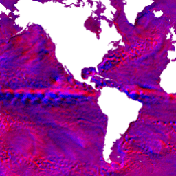
The Hybrid Coordinate Ocean Model (HYCOM) is a data-assimilative hybrid isopycnal-sigma-pressure (generalized) coordinate ocean model. The subset of HYCOM data hosted in EE contains the variables salinity, temperature, velocity, and elevation. They have been interpolated to a uniform 0.08 degree lat/long grid between 80.48°S and … hycom nopp oceans velocity water