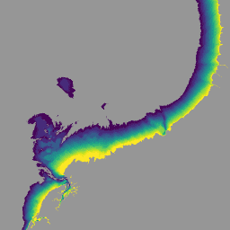
국가 조간대 디지털 고도 모델(NIDEM. Bishop-Taylor et al. 2018, 2019)은 오스트레일리아의 노출된 조간대에 대한 대륙 규모의 고도 데이터 세트입니다. NIDEM은 25m 공간 해상도로 오스트레일리아의 조간대 모래 해변과 해안, 갯벌, 암석 해안, 산호초의 3차원 표현을 처음으로 제공하여 …
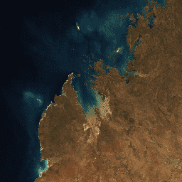
이 제품은 Digital Earth Australia에서 제공되는 Landsat 8 및 9 데이터의 시계열을 활용하는 통계 도구를 제공하여 일반적인 조건과 특정 연도의 지역 변화량을 보여주는 연간 이미지를 제공합니다. 2022년 이후 캘린더 연도의 경우 Landsat 8 및 …
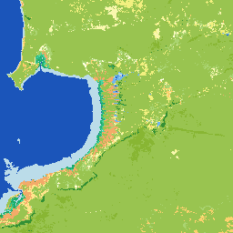
Digital Earth Australia (DEA) 토지 피복은 식량농업기구 토지 피복 분류 시스템 분류 버전 2 (Di Gregorio 및 Jansen, 1998; 2005)를 사용하여 오스트레일리아의 연간 토지 피복 분류를 제공합니다. DEA 토지 피복은 30년 이상의 위성 이미지를 …의 증거로 변환합니다.
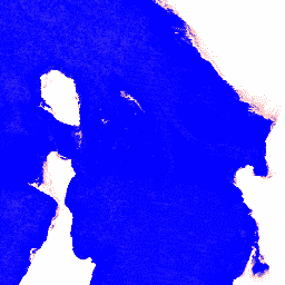
Digital Earth Australia (DEA) Water Observations는 알고리즘을 사용하여 Landsat 위성 이미지의 각 픽셀을 '습함', '건조함' 또는 '유효하지 않음'으로 분류합니다. Water Observations Statistics는 Landsat 위성이 매년 특정 지역을 명확하게 관측한 횟수, …
[[["이해하기 쉬움","easyToUnderstand","thumb-up"],["문제가 해결됨","solvedMyProblem","thumb-up"],["기타","otherUp","thumb-up"]],[["필요한 정보가 없음","missingTheInformationINeed","thumb-down"],["너무 복잡함/단계 수가 너무 많음","tooComplicatedTooManySteps","thumb-down"],["오래됨","outOfDate","thumb-down"],["번역 문제","translationIssue","thumb-down"],["샘플/코드 문제","samplesCodeIssue","thumb-down"],["기타","otherDown","thumb-down"]],[],[],["The datasets provide geospatial information about Australia, focusing on land and water features. The National Intertidal Digital Elevation Model (NIDEM) offers a 25m-resolution, 3D representation of Australia's intertidal zone. Several datasets analyze Landsat data, providing annual \"average\" cloud-free images and change metrics. The Land Cover dataset uses satellite imagery to classify Australia's land annually, utilizing the Food and Agriculture Organisation's Land Cover Classification System. Water Observations Statistics classifies each pixel as 'wet', 'dry', or 'invalid'.\n"]]