Datasets tagged finland in Earth Engine
Mit Sammlungen den Überblick behalten
Sie können Inhalte basierend auf Ihren Einstellungen speichern und kategorisieren.
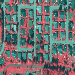
NLS-Orthophotos sind ein Luftbild-Dataset, das ganz Finnland abdeckt. Diese Daten werden von Mavi(Agency for Rural Affairs) bereitgestellt. Ein Orthofoto ist eine Kombination aus mehreren einzelnen Luftbildern. Das Dataset mit Luftbildern im Orthophoto-Format ist als das neueste Dataset verfügbar …
NLS-Orthophotos sind ein Luftbild-Dataset, das ganz Finnland abdeckt. Diese Daten werden von SMK(The Energy Agency, früher abgekürzt SMK) bereitgestellt. Ein Orthofoto ist eine Kombination aus mehreren einzelnen Luftbildern. Der Datensatz mit Luftbildern im Orthophoto-Format ist als …
NLS-Orthophotos sind ein Luftbild-Dataset, das ganz Finnland abdeckt. Diese Daten werden von SMK(The Energy Agency, früher abgekürzt SMK) bereitgestellt. Ein Orthofoto ist eine Kombination aus mehreren einzelnen Luftbildern. Das Luftbild-Dataset im Orthophoto-Format ist als … verfügbar.
[[["Leicht verständlich","easyToUnderstand","thumb-up"],["Mein Problem wurde gelöst","solvedMyProblem","thumb-up"],["Sonstiges","otherUp","thumb-up"]],[["Benötigte Informationen nicht gefunden","missingTheInformationINeed","thumb-down"],["Zu umständlich/zu viele Schritte","tooComplicatedTooManySteps","thumb-down"],["Nicht mehr aktuell","outOfDate","thumb-down"],["Problem mit der Übersetzung","translationIssue","thumb-down"],["Problem mit Beispielen/Code","samplesCodeIssue","thumb-down"],["Sonstiges","otherDown","thumb-down"]],[],[],["Finland's aerial photo data, known as NLS Orthophotos, is available as orthophotos, created from combined individual aerial photos. Datasets cover all of Finland and are provided by Mavi (Agency for Rural Affairs) and SMK (The Energy Agency). The data is available in orthophoto format with 50 cm resolution, with one dataset tagged as RGB and two datasets tagged as NRG (falsecolor). These datasets are considered the most recent datasets.\n"]]