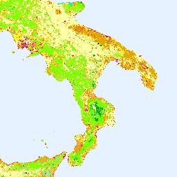
L'inventaire CORINE (coordination of information on the environment) Land Cover (CLC) a été lancé en 1985 pour normaliser la collecte de données sur les terres en Europe afin de soutenir l'élaboration de politiques environnementales. Le projet est coordonné par l'Agence européenne pour l'environnement (AEE) dans le cadre de l'UE…
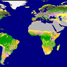
Le Copernicus Global Land Service (CGLS) est désigné comme un composant du service terrestre pour exploiter un composant de service polyvalent qui fournit une série de produits biogéophysiques sur l'état et l'évolution de la surface terrestre à l'échelle mondiale. La carte dynamique de la couverture terrestre à l'adresse …
[[["Facile à comprendre","easyToUnderstand","thumb-up"],["J'ai pu résoudre mon problème","solvedMyProblem","thumb-up"],["Autre","otherUp","thumb-up"]],[["Il n'y a pas l'information dont j'ai besoin","missingTheInformationINeed","thumb-down"],["Trop compliqué/Trop d'étapes","tooComplicatedTooManySteps","thumb-down"],["Obsolète","outOfDate","thumb-down"],["Problème de traduction","translationIssue","thumb-down"],["Mauvais exemple/Erreur de code","samplesCodeIssue","thumb-down"],["Autre","otherDown","thumb-down"]],[],[],["The Copernicus program provides land cover data through two key initiatives. The CORINE Land Cover (CLC) inventory, initiated in 1985 and coordinated by the EEA, standardizes land data collection in Europe. The Copernicus Global Land Service (CGLS) offers bio-geophysical products and dynamic land cover maps at a global scale, providing insights into land surface status and evolution. Both use the European Union's resources, are associated with the European Environment Agency (EEA), European Space Agency (ESA), and focus on land cover.\n"]]