- Disponibilité de l'ensemble de données
- 2015-01-01T00:00:00Z–2019-12-31T23:59:59Z
- Producteur de l'ensemble de données
- Copernicus
- Tags
Description
Le Copernicus Global Land Service (CGLS) est désigné comme un composant du service terrestre pour exploiter un composant de service polyvalent qui fournit une série de produits biogéophysiques sur l'état et l'évolution de la surface terrestre à l'échelle mondiale.
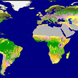
La carte dynamique de la couverture terrestre à une résolution de 100 m (CGLS-LC100) est un nouveau produit du portefeuille CGLS. Elle fournit une carte mondiale de la couverture terrestre à une résolution spatiale de 100 m. Le produit CGLS Land Cover fournit un schéma principal de couverture des sols. En plus de ces classes discrètes, le produit inclut également des couches de champs continus pour toutes les classes de couverture terrestre de base, qui fournissent des estimations proportionnelles de la couverture végétale/du sol pour les types de couverture terrestre. Ce système de classification continue peut mieux représenter les zones de couverture terrestre hétérogènes que le système de classification standard et, à ce titre, peut être adapté à l'utilisation des applications (par exemple, la surveillance des forêts, la surveillance des cultures, la biodiversité et la conservation, la surveillance de l'environnement et de la sécurité en Afrique, la modélisation du climat, etc.).
Ces cartes cohérentes de couverture terrestre (v3.0.1) sont fournies pour la période 2015-2019 sur l'ensemble du globe. Elles sont issues des séries temporelles PROBA-V 100 m, d'une base de données de sites d'entraînement de couverture terrestre de haute qualité et de plusieurs ensembles de données auxiliaires, atteignant une précision de 80 % au niveau 1 pour toutes les années. Il est prévu de fournir des mises à jour annuelles à partir de 2020 à l'aide d'une série temporelle Sentinel.
Voir également :
Bandes
Bandes de fréquences
Taille des pixels : 100 mètres (toutes les bandes)
| Nom | Unités | Min | Max | Taille des pixels | Description |
|---|---|---|---|---|---|
discrete_classification |
0 | 200 | 100 mètres | Classification de la couverture terrestre |
|
discrete_classification-proba |
% | 0 | 100 | 100 mètres | Indicateur de qualité (probabilité de classification) de la classification discrète |
forest_type |
0 | 5 | 100 mètres | Type de forêt pour tous les pixels dont le pourcentage de couverture végétale arborée est supérieur à 1 % |
|
bare-coverfraction |
% | 0 | 100 | 100 mètres | Pourcentage de couverture végétale pour la classe de couverture terrestre "végétation clairsemée ou nulle" |
crops-coverfraction |
% | 0 | 100 | 100 mètres | Pourcentage de couverture végétale pour la classe de couverture des terres cultivées |
grass-coverfraction |
% | 0 | 100 | 100 mètres | Pourcentage de couverture végétale pour la classe de couverture terrestre de la végétation herbacée |
moss-coverfraction |
% | 0 | 100 | 100 mètres | Pourcentage de couverture végétale pour la classe de couverture terrestre "mousse et lichen" |
shrub-coverfraction |
% | 0 | 100 | 100 mètres | Pourcentage de couverture végétale pour la classe de couverture des arbustes |
tree-coverfraction |
% | 0 | 100 | 100 mètres | Pourcentage de couverture végétale pour la classe de couverture forestière |
snow-coverfraction |
% | 0 | 100 | 100 mètres | Pourcentage de couverture du sol pour la classe de couverture du sol "Neige et glace" |
urban-coverfraction |
% | 0 | 100 | 100 mètres | Pourcentage de couverture du sol pour la classe de couverture du sol "Zone bâtie" |
water-permanent-coverfraction |
% | 0 | 100 | 100 mètres | Pourcentage de couverture du sol pour la classe de couverture du sol "Eau permanente" |
water-seasonal-coverfraction |
% | 0 | 100 | 100 mètres | Pourcentage de couverture du sol pour la classe de couverture terrestre saisonnière de l'eau |
data-density-indicator |
0 | 100 | 100 mètres | Indicateur de densité des données pour les données d'entrée de l'algorithme |
|
change-confidence |
0 | 3 | 100 mètres | Cette couche n'est fournie que pour les années postérieures à l'année de référence 2015.
|
Tableau des classes discrete_classification
| Valeur | Couleur | Description |
|---|---|---|
| 0 | #282828 | Inconnu. Aucune donnée satellite ou pas assez de données satellite disponibles. |
| 20 | #ffbb22 | Arbustes. Plantes ligneuses vivaces avec des tiges persistantes et ligneuses, sans tige principale définie, mesurant moins de 5 m de haut. Le feuillage des arbustes peut être persistant ou caduc. |
| 30 | #ffff4c | Végétation herbacée. Plantes sans tige ni pousses persistantes au-dessus du sol et sans structure ferme définie. Le couvert arboré et arbustif est inférieur à 10 %. |
| 40 | #f096ff | Végétation cultivée et gérée / agriculture. Terres couvertes de cultures temporaires, suivies d'une récolte et d'une période de sol nu (par exemple, systèmes de monoculture et de polyculture). Notez que les cultures ligneuses pérennes seront classées dans le type de couverture forestière ou arbustive approprié. |
| 50 | #fa0000 | Zone urbaine / bâtie Terres recouvertes de bâtiments et d'autres structures artificielles. |
| 60 | #b4b4b4 | Végétation clairsemée ou inexistante. Terres avec sol, sable ou roches à nu, et dont la couverture végétale ne dépasse jamais 10 % au cours de l'année. |
| 70 | #f0f0f0 | Neige et glace Terres recouvertes de neige ou de glace tout au long de l'année. |
| 80 | #0032c8 | Plans d'eau permanents. Lacs, réservoirs et rivières Il peut s'agir de plans d'eau douce ou salée. |
| 90 | #0096a0 | Zone humide herbacée. Terres avec un mélange permanent d'eau et de végétation herbacée ou ligneuse. La végétation peut être présente dans l'eau salée, saumâtre ou douce. |
| 100 | #fae6a0 | Mousse et lichen. |
| 111 | #58481f | Forêt fermée, feuillage persistant. La canopée est supérieure à 70 % et presque tous les conifères restent verts toute l'année. La canopée est toujours recouverte de feuillage vert. |
| 112 | #009900 | Forêt fermée, feuilles larges et persistantes. Couvert forestier > 70 %, presque tous les arbres à feuilles caduques restent verts toute l'année. La canopée est toujours recouverte de feuillage vert. |
| 113 | #70663e | Forêt fermée, à feuilles caduques en forme d'aiguilles. La canopée est supérieure à 70 % et se compose de communautés d'arbres à feuilles en aiguilles saisonnières avec un cycle annuel de périodes de feuillage et de défeuillage. |
| 114 | #00cc00 | Forêt fermée, à feuilles caduques et larges. La canopée est supérieure à 70 % et se compose de communautés d'arbres à feuilles caduques saisonnières avec un cycle annuel de périodes de feuillage et de défeuillage. |
| 115 | #4e751f | Forêt fermée, mixte. |
| 116 | #007800 | Forêt fermée ne correspondant à aucune des autres définitions. |
| 121 | #666000 | Forêt ouverte, feuillage persistant. La couche supérieure est composée d'arbres (15 à 70 %), tandis que la deuxième couche est un mélange d'arbustes et de prairies. Presque tous les conifères restent verts toute l'année. La canopée est toujours recouverte de feuillage vert. |
| 122 | #8db400 | Forêt ouverte, feuillus à feuilles persistantes. La couche supérieure est composée d'arbres (15 à 70 %) et la deuxième couche est un mélange d'arbustes et de prairies. Presque tous les arbres à feuilles caduques restent verts toute l'année. La canopée est toujours recouverte de feuillage vert. |
| 123 | #8d7400 | Forêt ouverte, feuillus à aiguilles caduques. La couche supérieure (arbres de 15 à 70 %) et la deuxième couche (mélange d'arbustes et de prairies) sont constituées de communautés d'arbres à feuilles caduques saisonniers avec un cycle annuel de périodes de feuillage et de défeuillage. |
| 124 | #a0dc00 | Forêt ouverte, à feuilles caduques et larges. La couche supérieure (arbres) représente 15 à 70 % de la surface, tandis que la couche inférieure (arbustes et prairies) est composée de communautés d'arbres à feuilles caduques saisonniers avec un cycle annuel de périodes de feuillage et de défeuillage. |
| 125 | #929900 | Forêt ouverte, mixte. |
| 126 | #648c00 | Forêt ouverte ne correspondant à aucune des autres définitions. |
| 200 | #000080 | Océans, mers. Il peut s'agir de plans d'eau douce ou salée. |
Tableau des classes de forest_type
| Valeur | Couleur | Description |
|---|---|---|
| 0 | #282828 | Inconnu |
| 1 | #666000 | Feuillage persistant |
| 2 | #009900 | Feuilles larges et persistantes |
| 3 | #70663e | Feuilles caduques en forme d'aiguilles |
| 4 | #a0dc00 | Feuilles caduques |
| 5 | #929900 | Mélange de types de forêts |
Propriétés des images
Propriétés des images
| Nom | Type | Description |
|---|---|---|
| discrete_classification_class_names | STRING_LIST | Noms des classes de couverture des sols |
| discrete_classification_class_palette | STRING_LIST | Palette de classes de couverture terrestre |
| discrete_classification_class_values | INT_LIST | Valeur de la classification de la couverture terrestre. |
| forest_type_class_names | STRING_LIST | noms des classes de couverture forestière |
| forest_type_class_palette | STRING_LIST | Palette de classes de couverture forestière |
| forest_type_class_values | INT_LIST | valeurs de classe de couverture forestière |
Conditions d'utilisation
Conditions d'utilisation
En tant que produit officiel de la composante mondiale du service Copernicus Land, l'accès à cet ensemble de données sur l'occupation des sols est entièrement sans frais et ouvert à tous les utilisateurs.
Citations
Buchhorn, M. ; Lesiv, M. ; Tsendbazar, N. - E. ; Herold, M. ; Bertels, L. ; Smets, B. Couches de couverture terrestre mondiale Copernicus, collection 2. Remote Sensing 2020, 12Volume 108, 1044. doi:10.3390/rs12061044
Buchhorn, M., Smets, B., Bertels, L., Roo, B. D., Lesiv, M., Tsendbazar, N.-E., Herold, M., & Fritz, S. (2020). Copernicus Global Land Service: Land Cover 100m: collection 3: epoch 2017: Globe (Version V3.0.1) [Ensemble de données]. Zenodo.
Buchhorn, M., Smets, B., Bertels, L., Roo, B. D., Lesiv, M., Tsendbazar, N.-E., Herold, M., & Fritz, S. (2020). Copernicus Global Land Service: Land Cover 100m: collection 3: epoch 2018: Globe (Version V3.0.1) [Ensemble de données]. Zenodo.
Buchhorn, M., Smets, B., Bertels, L., Roo, B. D., Lesiv, M., Tsendbazar, N.-E., Herold, M., & Fritz, S. (2020). Copernicus Global Land Service: Land Cover 100m: collection 3: epoch 2015: Globe (Version V3.0.1) [Ensemble de données]. Zenodo.
Buchhorn, M., Smets, B., Bertels, L., Roo, B. D., Lesiv, M., Tsendbazar, N.-E., Herold, M., & Fritz, S. (2020). Copernicus Global Land Service: Land Cover 100m: collection 3: epoch 2019: Globe (Version V3.0.1) [Ensemble de données]. Zenodo.
DOI
- https://doi.org/10.5281/ZENODO.3518036
- https://doi.org/10.5281/ZENODO.3518038
- https://doi.org/10.5281/ZENODO.3939038
- https://doi.org/10.5281/ZENODO.3939050
- https://doi.org/10.5281/zenodo.3518026
- https://doi.org/10.5281/zenodo.3518036
- https://doi.org/10.5281/zenodo.3518038
- https://doi.org/10.5281/zenodo.3939038
- https://doi.org/10.5281/zenodo.3939050
Explorer avec Earth Engine
Éditeur de code (JavaScript)
var dataset = ee.Image('COPERNICUS/Landcover/100m/Proba-V-C3/Global/2019')
.select('discrete_classification');

Map.setCenter(-88.6, 26.4, 1);

Map.addLayer(dataset, {}, 'Land Cover');
import ee
import geemap.core as geemap
Colab (Python)
dataset = ee.Image('COPERNICUS/Landcover/100m/Proba-V-C3/Global/2019').select(
    'discrete_classification'
)

m = geemap.Map()
m.set_center(-88.6, 26.4, 1)
m.add_layer(dataset, {}, 'Land Cover')
m