Page Summary
-
Global forest classification data is available for 2020 at approximately 30m resolution to support IPCC Aboveground Biomass Tier 1 estimates.
-
Global maps of aboveground and belowground biomass carbon density for 2010 are provided at 300-m resolution.
-
Gridded vegetation structure metrics and biomass density derived from NASA GEDI are available at 1KM, 6KM, and 12KM pixel sizes.
-
Detailed spatial information on forest characteristics, including biomass and carbon, for the continental United States is available from USFS TreeMap for 2016, 2020, and 2022.
-
A global dataset of above- and below-ground terrestrial carbon storage for circa 2010 and a pantropical map of above-ground live woody biomass density are available.
-
ESA CCI Above-Ground Biomass for 2007, 2010, 2015-2022 (v6.0)
This dataset updated to v6.0 provides estimates of forest above-ground biomass for the years 2007, 2010, 2015, 2016, 2017, 2018, 2019, 2020, 2021, and 2022. These estimates are derived from a combination of Earth observation data, depending on the year, obtained from the Copernicus Sentinel-1 … biomass cci ecosystems esa forest -
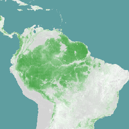
Global 2020 Forest Classification for IPCC Aboveground Biomass Tier 1 Estimates, V1

This dataset provides classes of global forests delineated by status/condition in 2020 at approximately 30m resolution. The data support generating Tier 1 estimates for Aboveground dry woody Biomass Density (AGBD) in natural forests in the 2019 Refinement to the 2006 IPCC Guidelines for National Greenhouse … aboveground biomass carbon classification forest forest-biomass -
Global Aboveground and Belowground Biomass Carbon Density Maps
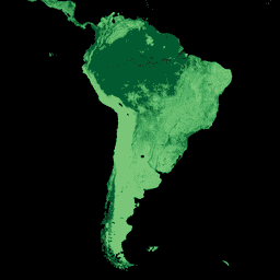
This dataset provides temporally consistent and harmonized global maps of aboveground and belowground biomass carbon density for the year 2010 at a 300-m spatial resolution. The aboveground biomass map integrates land-cover specific, remotely sensed maps of woody, grassland, cropland, and tundra biomass. Input maps were … aboveground biomass carbon density forest forest-biomass -
Gridded GEDI Vegetation Structure Metrics and Biomass Density with COUNTS metrics, 12KM pixel size
This dataset consists of near-global, analysis-ready, multi-resolution gridded vegetation structure metrics derived from NASA Global Ecosystem Dynamics Investigation (GEDI) Level 2 and 4A products associated with 25-m diameter lidar footprints. This dataset provides a comprehensive representation of near-global vegetation structure that is inclusive of the … biomass canopy forest forest-biomass gedi larse -
Gridded GEDI Vegetation Structure Metrics and Biomass Density with COUNTS metrics, 1KM pixel size
This dataset consists of near-global, analysis-ready, multi-resolution gridded vegetation structure metrics derived from NASA Global Ecosystem Dynamics Investigation (GEDI) Level 2 and 4A products associated with 25-m diameter lidar footprints. This dataset provides a comprehensive representation of near-global vegetation structure that is inclusive of the … biomass canopy forest forest-biomass gedi larse -
Gridded GEDI Vegetation Structure Metrics and Biomass Density with COUNTS metrics, 6KM pixel size
This dataset consists of near-global, analysis-ready, multi-resolution gridded vegetation structure metrics derived from NASA Global Ecosystem Dynamics Investigation (GEDI) Level 2 and 4A products associated with 25-m diameter lidar footprints. This dataset provides a comprehensive representation of near-global vegetation structure that is inclusive of the … biomass canopy forest forest-biomass gedi larse -
Gridded GEDI Vegetation Structure Metrics and Biomass Density, 12KM pixel size
This dataset consists of near-global, analysis-ready, multi-resolution gridded vegetation structure metrics derived from NASA Global Ecosystem Dynamics Investigation (GEDI) Level 2 and 4A products associated with 25-m diameter lidar footprints. This dataset provides a comprehensive representation of near-global vegetation structure that is inclusive of the … biomass canopy forest forest-biomass gedi larse -
Gridded GEDI Vegetation Structure Metrics and Biomass Density, 1KM pixel size
This dataset consists of near-global, analysis-ready, multi-resolution gridded vegetation structure metrics derived from NASA Global Ecosystem Dynamics Investigation (GEDI) Level 2 and 4A products associated with 25-m diameter lidar footprints. This dataset provides a comprehensive representation of near-global vegetation structure that is inclusive of the … biomass canopy forest forest-biomass gedi larse -
Gridded GEDI Vegetation Structure Metrics and Biomass Density, 6KM pixel size
This dataset consists of near-global, analysis-ready, multi-resolution gridded vegetation structure metrics derived from NASA Global Ecosystem Dynamics Investigation (GEDI) Level 2 and 4A products associated with 25-m diameter lidar footprints. This dataset provides a comprehensive representation of near-global vegetation structure that is inclusive of the … biomass canopy forest forest-biomass gedi larse -
USFS TreeMap v2016 (Conterminous United States)
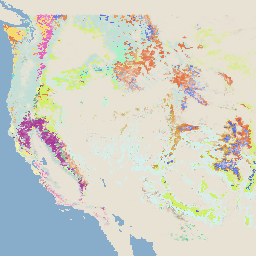
This product is part of the TreeMap data suite. It provides detailed spatial information on forest characteristics including number of live and dead trees, biomass, and carbon across the entire forested extent of the continental United States in 2016. TreeMap v2016 contains one image, a … biomass carbon climate-change conus forest forest-biomass -
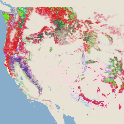
USFS TreeMap v2020

This product is part of the TreeMap data suite. It provides detailed spatial information on forest characteristics including number of live and dead trees, biomass, and carbon across the entire forested extent of the United States in 2020. TreeMap v2020 contains 22-band 30 x 30m … aboveground biomass carbon climate-change conus forest -
USFS TreeMap v2022
This product is part of the TreeMap data suite. It provides detailed spatial information on forest characteristics including number of live and dead trees, biomass, and carbon across the entire forested extent of the United States in 2022. TreeMap v2022 contains 22-band 30 x 30m … aboveground biomass carbon climate-change conus forest -
WCMC Above and Below Ground Biomass Carbon Density
This dataset represents above- and below-ground terrestrial carbon storage (tonnes (t) of C per hectare (ha)) for circa 2010. The dataset was constructed by combining the most reliable publicly available datasets and overlaying them with the ESA CCI landcover map for the year 2010 (ESA, … biomass carbon forest-biomass wcmc -
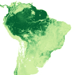
WHRC Pantropical National Level Carbon Stock Dataset
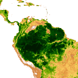
A national-level map of above-ground live woody biomass density for tropical countries at 500m. This dataset was assembled from a combination of co-located field measurements, LiDAR observations, and imagery recorded from the Moderate Resolution Imaging Spectroradiometer (MODIS). aboveground biomass carbon forest-biomass geophysical umd