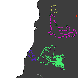
MODIS डेटासेट MCD64A1 के आधार पर आग की सीमाएं. डेटा को एक ऐसे एल्गोरिदम के आधार पर कंप्यूट किया गया था जो जले हुए इलाकों के पैच के बीच, समय और जगह के हिसाब से संबंध को ग्राफ़ स्ट्रक्चर में एन्कोड करने पर निर्भर करता है. हर आग का एक यूनीक नंबर होता है, जिससे इवेंट की पहचान की जाती है.
MODIS डेटासेट MCD64A1 के आधार पर आग की सीमाएं. डेटा को एक ऐसे एल्गोरिदम के आधार पर कंप्यूट किया गया था जो जले हुए इलाकों के पैच के बीच, समय और जगह के हिसाब से संबंध को ग्राफ़ स्ट्रक्चर में एन्कोड करने पर निर्भर करता है. हर आग का एक यूनीक नंबर होता है, जिससे इवेंट की पहचान की जाती है.
[[["समझने में आसान है","easyToUnderstand","thumb-up"],["मेरी समस्या हल हो गई","solvedMyProblem","thumb-up"],["अन्य","otherUp","thumb-up"]],[["वह जानकारी मौजूद नहीं है जो मुझे चाहिए","missingTheInformationINeed","thumb-down"],["बहुत मुश्किल है / बहुत सारे चरण हैं","tooComplicatedTooManySteps","thumb-down"],["पुराना","outOfDate","thumb-down"],["अनुवाद से जुड़ी समस्या","translationIssue","thumb-down"],["सैंपल / कोड से जुड़ी समस्या","samplesCodeIssue","thumb-down"],["अन्य","otherDown","thumb-down"]],[],[],["The datasets, \"GlobFire Daily Fire Event Detection\" and \"GlobFire Final Fire Event Detection,\" both use the MODIS MCD64A1 dataset to define fire boundaries. They employ an algorithm that encodes the spatial and temporal relationships between burned area patches in a graph structure. Each identified fire is assigned a unique number. The data is categorized by area, burnt regions, disaster, fire occurrences, GlobFire events, and MCD64A1 data.\n"]]