Page Summary
-
The CryoSat-2 Antarctica 1km DEM provides a digital elevation model of the Antarctic ice sheet and ice shelves based on satellite radar altimeter observations.
-
The Landsat Image Mosaic of Antarctica (LIMA) datasets offer seamless and virtually cloudless mosaics created from processed Landsat 7 ETM+ scenes.
-
The LIMA datasets include processed Landsat scenes in 16 bit, metadata for these scenes, and a 16-Bit Pan-Sharpened Mosaic.
-
CryoSat-2 Antarctica 1km DEM
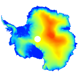
This dataset is a digital elevation model (DEM) of the Antarctic ice sheet and ice shelves based on observations recorded by the CryoSat-2 satellite radar altimeter between July 2010 and July 2016. The DEM is formed from spatio-temporal fits to elevation measurements accumulated within 1, … antarctica dem elevation elevation-topography polar -
Landsat Image Mosaic of Antarctica (LIMA) - Processed Landsat Scenes (16 bit)
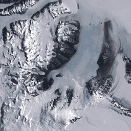
The Landsat Image Mosaic of Antarctica (LIMA) is a seamless and virtually cloudless mosaic created from processed Landsat 7 ETM+ scenes. Processed Landsat Scenes (16 bit) are Level 1Gt NLAPS scenes converted to 16 bit, processed with sun-angle correction, and converted to reflectance values (Bindschadler … antarctica ice landsat-derived lima mosaic satellite-imagery -
Landsat Image Mosaic of Antarctica (LIMA) - Processed Landsat Scenes (16 bit) Metadata
The Landsat Image Mosaic of Antarctica (LIMA) is a seamless and virtually cloudless mosaic created from processed Landsat 7 ETM+ scenes. Processed Landsat Scenes (16 bit) are Level 1Gt NLAPS scenes converted to 16 bit, processed with sun-angle correction, and converted to reflectance values (Bindschadler … antarctica ice landsat-derived lima mosaic satellite-imagery -
Landsat Image Mosaic of Antarctica (LIMA) 16-Bit Pan-Sharpened Mosaic

The Landsat Image Mosaic of Antarctica (LIMA) is a seamless and virtually cloudless mosaic created from processed Landsat 7 ETM+ scenes. This LIMA dataset is the 16-bit Intermediate LIMA. The mosaic consists of pan-sharpened normalized surface reflectance scenes (Landsat ETM+ bands 1, 2, 3, and … antarctica ice landsat-derived lima mosaic satellite-imagery