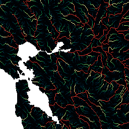
HydroSHEDS, bölgesel ve küresel ölçekli uygulamalar için tutarlı bir biçimde hidrografik bilgiler sağlayan bir harita ürünüdür. Nehir ağları, su havzası sınırları, drenaj yönleri ve akış birikimleri dahil olmak üzere çeşitli ölçeklerde coğrafi referanslı veri kümeleri (vektör ve raster) sunar. HydroSHEDS, … temel alınarak oluşturulmuştur.
HydroSHEDS, bölgesel ve küresel ölçekli uygulamalar için tutarlı bir biçimde hidrografik bilgiler sağlayan bir harita ürünüdür. Nehir ağları, su havzası sınırları, drenaj yönleri ve akış birikimleri dahil olmak üzere çeşitli ölçeklerde coğrafi referanslı veri kümeleri (vektör ve raster) sunar. HydroSHEDS, … temel alınarak oluşturulmuştur.
[[["Anlaması kolay","easyToUnderstand","thumb-up"],["Sorunumu çözdü","solvedMyProblem","thumb-up"],["Diğer","otherUp","thumb-up"]],[["İhtiyacım olan bilgiler yok","missingTheInformationINeed","thumb-down"],["Çok karmaşık / çok fazla adım var","tooComplicatedTooManySteps","thumb-down"],["Güncel değil","outOfDate","thumb-down"],["Çeviri sorunu","translationIssue","thumb-down"],["Örnek veya kod sorunu","samplesCodeIssue","thumb-down"],["Diğer","otherDown","thumb-down"]],[],[],["HydroSHEDS is a mapping product delivering hydrographic data for both regional and global applications. It includes geo-referenced datasets in vector and raster formats. These datasets encompass river networks, watershed boundaries, drainage directions, and flow accumulations at varying scales. This product provides consistent hydrographic information by mapping the geophysical flow and drainage. The product is provided at both 15 and 30 arc-seconds resolution.\n"]]