Geoscience Australia 为决策者提供地球观测服务、专家建议和信息。计划目标如下:
- 确保持续访问遥感信息,以支持政府的优先事项。
- 在政府、行业和更广泛的社区中推广卫星图像的使用和价值。
- 通过提取价值并充分利用 EOS 的潜力,推动遥感科学的发展
- 提供数据管理服务,以确保对数据的访问权限,以及
- 为灾害和紧急情况提供全国性图像协调服务。
-
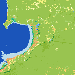
美国国家潮汐数字海拔模型 25 米 1.0.0 [已废弃]
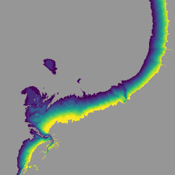
国家潮汐数字海拔模型 (NIDEM;Bishop-Taylor 等人,2018、2019) 是澳大利亚露出式潮汐区的大陆级海拔数据集。NIDEM 首次以三维方式呈现了澳大利亚的潮间沙滩和海岸、潮汐平原以及 25 米深处的岩石海岸和礁石。 australia dem ga geoscience-aus-cat landsat-derived publisher-dataset -
DEA 几何中位数和中位绝对偏差 - Landsat 5 3.1.0 [已废弃]
此产品提供了统计工具,可利用 Digital Earth Australia 中提供的 Landsat 5 数据时间序列,提供有关一般情况和给定年份某个区域变化幅度的年度图片。产品的地理中位数部分提供了一个不含云的“平均”… 澳大利亚 ga geoscience-aus-cat landsat-derived publisher-dataset -
DEA 几何中位数和中位绝对偏差 - Landsat 7 3.1.0 [已废弃]
此产品提供了统计工具,可利用 Digital Earth Australia 中提供的 Landsat 7 数据时间序列,提供有关一般情况和给定年份某个区域变化幅度的年度图片。产品的地理中位数部分提供了一个不含云的“平均”… 澳大利亚 ga geoscience-aus-cat landsat-derived publisher-dataset -
DEA 几何中位数和中位绝对偏差 - Landsat 8 和 9 v4.0.0 [已废弃]
此产品提供了统计工具,可利用 Digital Earth Australia 中提供的 Landsat 8 和 9 数据的时间序列,提供有关一般情况和给定年份某个区域变化幅度的年度图片。对于 2022 年及之后的日历年,Landsat 8 和 … 澳大利亚 ga geoscience-aus-cat landsat-derived publisher-dataset -
DEA 土地覆盖 1.0.0 [已废弃]
Digital Earth Australia (DEA) Land Cover 使用联合国粮食及农业组织土地覆盖分类系统分类法版本 2 (Di Gregorio and Jansen, 1998; 2005) 为澳大利亚提供年度土地覆盖分类。DEA 土地覆盖数据集可将 30 多年的卫星图像转化为以下证据: 澳大利亚 ga geoscience-aus-cat landcover landsat-derived publisher-dataset -
DEA 水文观测统计数据 3.1.6 [已废弃]
Digital Earth Australia (DEA) Water Observations 使用算法将 Landsat 卫星图像中的每个像素分类为“湿区”“干区”或“无效”。水文观测统计信息提供了以下信息:Landsat 卫星每年能够清晰看到某个区域的次数、... australia ga geoscience-aus-cat landsat-derived publisher-dataset water