- 目錄擁有者
- MapBiomas
- 資料集開放期間
- 1985-01-01T00:00:00Z–2024-12-31T00:00:00Z
- 資料集產生者
- MapBiomas
- 聯絡資訊
- contato@mapbiomas.org
- 標記
說明
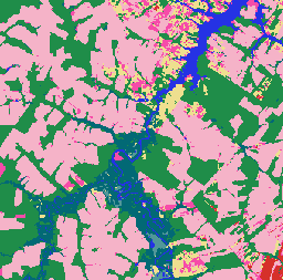
MapBiomas 巴西土地利用和地表覆蓋物 (LULC) 資料集是由 MapBiomas 專案每年製作,採用 Landsat 衛星影像和機器學習分類技術。這項資料集提供一致且主題詳細的地圖,解析度為 30 公尺,涵蓋數十年來的資料,每年都會更新。
集合中的每張圖片都包含年度土地覆蓋分類,像素值代表類別土地覆蓋類別,例如森林、農業、牧場、水體和都市地區。 分類圖例經過標準化處理,且每年都維持不變,因此可進行土地利用變化、森林砍伐、造林和其他地景動態的多時態分析。
分類依據為 Landsat 5 (TM)、Landsat 7 (ETM+)、Landsat 8 和 9 (OLI/TIRS) 的地表反射率資料,這些資料經過預先處理和鑲嵌,可產生每年無雲的合成影像。分類程序包括以參考樣本訓練的自動決策樹,以及區域專家進行的手動驗證。
每個影像都包含一個名為「classification」的波段,代表該特定年份、版本和集合 ID 的土地覆蓋分類。
如要進一步瞭解分類圖例、方法和準確度評估,請造訪 MapBiomas 網站。
建議您參考分類圖例,解讀類別值。 請注意,MapBiomas 提供的是離散分類地圖,而非機率。這些地圖最適合用於地圖轉換、時間序列分析和土地政策監控應用程式。
頻帶
波段
像素大小:30 公尺 (所有頻帶)
| 名稱 | 像素大小 | 說明 |
|---|---|---|
classification |
30 公尺 | 土地利用和地貌分類,整數值對應至 MapBiomas 圖例類別。 |
分類類別表
| 值 | 顏色 | 說明 |
|---|---|---|
| 1 | #1f8d49 | 森林 |
| 3 | #1f8d49 | 森林形成 |
| 4 | #7dc975 | 莽原形成 |
| 5 | #04381d | Mangrove |
| 6 | #007785 | Floodable Forest |
| 9 | #7a5900 | 造林 |
| 10 | #d6bc74 | 草本和灌木植被 |
| 11 | #519799 | 溼地 |
| 12 | #d6bc74 | 草地 |
| 14 | #ffefc3 | 農業 |
| 15 | #edde8e | 牧草地 |
| 18 | #e974ed | 農業 |
| 19 | #c27ba0 | 臨時作物 |
| 20 | #db7093 | 甘蔗 |
| 21 | #ffefc3 | 用途多元 |
| 22 | #d4271e | 無植被區域 |
| 23 | #ffa07a | 海灘、沙丘和沙地 |
| 24 | #d4271e | 都會區 |
| 25 | #db4d4f | 其他非植被區域 |
| 26 | #2532e4 | 水 |
| 29 | #ffaa5f | Rocky Outcrop |
| 30 | #9c0027 | 採礦 |
| 31 | #091077 | 水產養殖 |
| 32 | #fc8114 | 高鹽度潮間帶 |
| 33 | #2532e4 | 河流、湖泊和海洋 |
| 35 | #9065d0 | 棕櫚油 |
| 36 | #d082de | Perennial Crop |
| 39 | #f5b3c8 | 大豆 |
| 40 | #c71585 | Rice |
| 41 | #f54ca9 | 其他臨時作物 |
| 46 | #d68fe2 | 咖啡 |
| 47 | #9932cc | Citrus |
| 48 | #e6ccff | 其他多年生作物 |
| 49 | #02d659 | 有樹木的沙洲植被 |
| 50 | #ad5100 | 草本沙洲植被 |
| 62 | #ff69b4 | 棉花 (Beta 版) |
| 75 | #c12100 | 太陽光電發電廠 (Beta 版) |
圖片屬性
影像屬性
| 名稱 | 類型 | 說明 |
|---|---|---|
| 年 | INT | 土地利用和地貌分類的年份。 |
| 版本 | STRING | 土地利用和地貌分類的版本。 |
| collection_id | DOUBLE | 土地利用和地貌分類的集合 ID。 |
使用條款
使用條款
參考資料
Souza 等人 (2020 年) - Reconstructing Three Decades of Land Use and Land Cover Changes in Brazilian Biomes with Landsat Archive and Earth Engine - Remote Sensing, Volume 12, Issue 17, 10.3390/rs12172735。
DOI
使用 Earth Engine 探索
程式碼編輯器 (JavaScript)
/**
  MapBiomas Collection 10 - LULC Visualization for 2024
*/

// Define the asset path for MapBiomas Collection 10
var assetPath = 'projects/mapbiomas-public/assets/brazil/lulc/v1';

// Define the year for visualization
var year = 2024;

// Load the classified image for the year 2024 from Collection 10
var collection = ee.ImageCollection(assetPath)
	.filter(ee.Filter.eq('collection_id', 10.0))
	.filter(ee.Filter.eq('version', 'v1'))
	.filter(ee.Filter.eq('year', year));

// Define visualization parameters
var visParams = {
	min: 0,
	max: 75,  // Maximum class value in Collection 10
	palette: [
		'ffffff',  // [0] Not Observed
		'32a65e',  // [1] --
		'32a65e',  // [2] --
		'1f8d49',  // [3] Forest Formation
		'7dc975',  // [4] Savanna Formation
		'04381d',  // [5] Mangrove
		'026975',  // [6] Floodable Forest
		'000000',  // [7] --
		'000000',  // [8] --
		'7a6c00',  // [9] Forest Plantation
		'ad975a',  // [10] --
		'519799',  // [11] Wetland
		'd6bc74',  // [12] Grassland
		'd89f5c',  // [13] Other Non Forest Formations
		'FFFFB2',  // [14] --
		'edde8e',  // [15] Pasture
		'000000',  // [16] --
		'000000',  // [17] --
		'f5b3c8',  // [18] Agriculture
		'C27BA0',  // [19] --
		'db7093',  // [20] Sugar Cane
		'ffefc3',  // [21] Mosaic of Uses
		'db4d4f',  // [22] Non vegetated area
		'ffa07a',  // [23] Beach, Dune and Sand Spot
		'd4271e',  // [24] Urban Area
		'db4d4f',  // [25] Other Non Vegetated Areas
		'0000FF',  // [26] --
		'000000',  // [27] --
		'000000',  // [28] --
		'ffaa5f',  // [29] Rocky Outcrop
		'9c0027',  // [30] Mining
		'091077',  // [31] Aquaculture
		'fc8114',  // [32] Hypersaline Tidal Flat
		'2532e4',  // [33] Rivers, Lakes and Ocean
		'93dfe6',  // [34] Glacier
		'9065d0',  // [35] --
		'd082de',  // [36] --
		'000000',  // [37] --
		'000000',  // [38] --
		'f5b3c8',  // [39] Soybean
		'c71585',  // [40] Rice
		'f54ca9',  // [41] Other Temporary Crops
		'cca0d4',  // [42] --
		'dbd26b',  // [43] --
		'807a40',  // [44] --
		'e04cfa',  // [45] --
		'd68fe2',  // [46] Coffee
		'9932cc',  // [47] Citrus
		'e6ccff',  // [48] Other Perennial Crops
		'02d659',  // [49] Wooded Sandbank Vegetation
		'ad5100',  // [50] Herbaceous Sandbank Vegetation
		'000000',  // [51] --
		'000000',  // [52] --
		'000000',  // [53] --
		'000000',  // [54] --
		'000000',  // [55] --
		'000000',  // [56] --
		'CC66FF',  // [57] --
		'FF6666',  // [58] --
		'006400',  // [59] --
		'8d9e8b',  // [60] --
		'f5d5d5',  // [61] Salt Flats
		'ff69b4',  // [62] Cotton
		'ebf8b5',  // [63] --
		'000000',  // [64] --
		'000000',  // [65] --
		'91ff36',  // [66] --
		'7dc975',  // [67] --
		'e97a7a',  // [68] --
		'0fffe3',  // [69] Coral Reefs
		'000000',  // [70] --
		'000000',  // [71] --
		'000000',  // [72] --
		'000000',  // [73] --
		'000000',  // [74] --
		'c12100',  // [75] Photovoltaic Power Plant
	]
};

// Add the layer to the map
Map.addLayer(collection, visParams, 'MapBiomas LULC 2024');

// Center the map on the image with a zoom level of 5 (covers Brazil)
Map.centerObject(collection, 5);