- 目錄擁有者
- MapBiomas
- 資料集開放期間
- 1985-01-01T00:00:00Z–2024-12-31T00:00:00Z
- 資料集產生者
- MapBiomas
- 聯絡資訊
- contato@mapbiomas.org
- 標記
說明
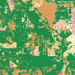
MapBiomas 每年都會使用 Landsat 衛星圖像和機器學習分類技術,製作玻利維亞的土地利用和地表覆蓋物 (LULC) 資料集。這項資料集提供 1985 年至 2024 年期間的年度地表覆蓋地圖,解析度為 30 公尺。
玻利維亞的領土橫跨多個主要生物群系,包括亞馬遜雨林、塞拉多、查科、潘塔納爾和安地斯山高地 (阿爾蒂普拉諾)。分類圖例反映了這種多樣性,其中包含安地斯生態系統特有的類別,例如安地斯草原和灌木叢,以及淹水的安地斯草原和灌木叢。
集合中的每張圖片都包含一個名為「classification」的波段,其中整數值代表該年度的類別土地覆蓋類別。分類依據為 Landsat 5 (TM)、Landsat 7 (ETM+)、Landsat 8 和 9 (OLI/TIRS) 的地表反射率資料,這些資料經過預先處理,可產生每年無雲的合成影像。分類程序會使用自動決策樹,並以參考樣本訓練,且經過區域專家驗證。
如要進一步瞭解分類圖例、方法和準確度評估,請造訪 MapBiomas 網站。
頻帶
波段
像素大小:30 公尺 (所有頻帶)
| 名稱 | 像素大小 | 說明 |
|---|---|---|
classification |
30 公尺 | 土地利用和地貌分類,整數值對應至 MapBiomas Bolivia 圖例類別。 |
分類類別表
| 值 | 顏色 | 說明 |
|---|---|---|
| 1 | #1f8d49 | 森林形成 |
| 3 | #1f8d49 | 森林 |
| 4 | #7dc975 | Open Forest |
| 6 | #026975 | 淹水森林 |
| 10 | #d6bc74 | 草地和灌木叢 |
| 11 | #519799 | 淹水的草地/灌木叢 |
| 12 | #d6bc74 | 草地/灌木叢 |
| 13 | #d89f5c | 其他非森林的天然地貌 |
| 14 | #ffefc3 | 農業 |
| 15 | #edde8e | 牧草地 |
| 18 | #e974ed | 農業 |
| 21 | #ffefc3 | 用途多元 |
| 22 | #d4271e | 無植被區域 |
| 23 | #ffa07a | 海灘、沙丘和沙洲 |
| 24 | #d4271e | 都市基礎架構 |
| 25 | #db4d4f | 其他無植被的人為區域 |
| 26 | #2532e4 | 水 |
| 27 | #ffffff | 未遵守 |
| 29 | #ffaa5f | 岩石露頭 |
| 30 | #9c0027 | 採礦 |
| 31 | #091077 | 水產養殖 |
| 33 | #2532e4 | 河流和湖泊 |
| 34 | #93dfe6 | 冰川 |
| 39 | #f5b3c8 | 大豆 |
| 61 | #f5d5d5 | 鹽灘 |
| 66 | #a89358 | 灌木叢 |
| 68 | #e97a7a | 其他無植被的自然區域 |
| 72 | #c1799c | 其他作物 |
| 81 | #c8c099 | 安地斯草原和灌木叢 |
| 82 | #66b2a3 | 淹水的安地斯山草原和灌木叢 |
圖片屬性
影像屬性
| 名稱 | 類型 | 說明 |
|---|---|---|
| 年 | INT | 土地利用和地貌分類的年份。 |
| 版本 | STRING | 土地利用和地貌分類的版本。 |
| collection_id | DOUBLE | 土地利用和地貌分類的集合 ID。 |
使用條款
使用條款
參考資料
Souza 等人 (2020 年) - Reconstructing Three Decades of Land Use and Land Cover Changes in Brazilian Biomes with Landsat Archive and Earth Engine - Remote Sensing, Volume 12, Issue 17, 10.3390/rs12172735。
DOI
使用 Earth Engine 探索
程式碼編輯器 (JavaScript)
/**
  MapBiomas Bolivia - Land Use and Land Cover V1
*/

var assetPath = 'projects/mapbiomas-public/assets/bolivia/lulc/v1';

var year = 2024;

var collection = ee.ImageCollection(assetPath)
  .filter(ee.Filter.eq('year', year));

var visParams = {
  min: 0,
  max: 82,
  palette: [
    '000000',  // [0] --
    '1f8d49',  // [1] Forest Formation
    '000000',  // [2] --
    '1f8d49',  // [3] Forest
    '7dc975',  // [4] Open Forest
    '000000',  // [5] --
    '026975',  // [6] Flooded Forest
    '000000',  // [7] --
    '000000',  // [8] --
    '000000',  // [9] --
    'd6bc74',  // [10] Grassland and shrubland
    '519799',  // [11] Flooded grassland/shrubland
    'd6bc74',  // [12] Grassland/shrubland
    'd89f5c',  // [13] Other non-forest natural formation
    'ffefc3',  // [14] Farming
    'edde8e',  // [15] Pasture
    '000000',  // [16] --
    '000000',  // [17] --
    'e974ed',  // [18] Agriculture
    '000000',  // [19] --
    '000000',  // [20] --
    'ffefc3',  // [21] Mosaic of Uses
    'd4271e',  // [22] Non-vegetated area
    'ffa07a',  // [23] Beach, dune and sandbank
    'd4271e',  // [24] Urban Infrastructure
    'db4d4f',  // [25] Other non-vegetated anthropic area
    '2532e4',  // [26] Water
    'ffffff',  // [27] Not observed
    '000000',  // [28] --
    'ffaa5f',  // [29] Rocky outcrop
    '9c0027',  // [30] Mining
    '091077',  // [31] Aquaculture
    '000000',  // [32] --
    '2532e4',  // [33] River and lake
    '93dfe6',  // [34] Glacier
    '000000',  // [35] --
    '000000',  // [36] --
    '000000',  // [37] --
    '000000',  // [38] --
    'f5b3c8',  // [39] Soybean
    '000000',  // [40] --
    '000000',  // [41] --
    '000000',  // [42] --
    '000000',  // [43] --
    '000000',  // [44] --
    '000000',  // [45] --
    '000000',  // [46] --
    '000000',  // [47] --
    '000000',  // [48] --
    '000000',  // [49] --
    '000000',  // [50] --
    '000000',  // [51] --
    '000000',  // [52] --
    '000000',  // [53] --
    '000000',  // [54] --
    '000000',  // [55] --
    '000000',  // [56] --
    '000000',  // [57] --
    '000000',  // [58] --
    '000000',  // [59] --
    '000000',  // [60] --
    'f5d5d5',  // [61] Salt flat
    '000000',  // [62] --
    '000000',  // [63] --
    '000000',  // [64] --
    '000000',  // [65] --
    'a89358',  // [66] Scrubland
    '000000',  // [67] --
    'e97a7a',  // [68] Other non-vegetated natural area
    '000000',  // [69] --
    '000000',  // [70] --
    '000000',  // [71] --
    'c1799c',  // [72] Other crops
    '000000',  // [73] --
    '000000',  // [74] --
    '000000',  // [75] --
    '000000',  // [76] --
    '000000',  // [77] --
    '000000',  // [78] --
    '000000',  // [79] --
    '000000',  // [80] --
    'c8c099',  // [81] Andean grassland and shrubland
    '66b2a3',  // [82] Flooded Andean grassland and shrubland
  ],
};

Map.addLayer(collection, visParams, 'MapBiomas Bolivia LULC ' + year);
Map.centerObject(collection, 6);