- 目录所有者
- MapBiomas
- 数据集可用时间
- 1985-01-01T00:00:00Z–2024-12-31T00:00:00Z
- 数据集生产者
- MapBiomas
- 联系人
- contato@mapbiomas.org
- 标签
说明
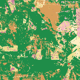
玻利维亚的 MapBiomas 土地利用和土地覆盖 (LULC) 数据集由 MapBiomas 项目每年使用 Landsat 卫星图像和机器学习分类技术生成。该数据集提供一致的年度土地覆盖地图,分辨率为 30 米,涵盖 1985 年至 2024 年期间。
玻利维亚的领土横跨几个主要的生物群落,包括亚马逊雨林、塞拉多、查科、潘塔纳尔和安第斯山脉高地 (Altiplano)。这种多样性反映在分类图例中,其中包括安第斯山脉生态系统特有的类别,例如安第斯山脉草地和灌木丛以及被淹没的安第斯山脉草地和灌木丛。
集合中的每个图像都包含一个名为“classification”的频段,其整数值表示该年份的分类土地覆盖类别。该分类基于 Landsat 5 (TM)、Landsat 7 (ETM+)、Landsat 8 和 9 (OLI/TIRS) 地表反射率数据,这些数据经过预处理以生成年度无云合成影像。分类过程使用经过参考样本训练并由区域专家验证的自动决策树。
如需了解详情、分类图例、方法和准确率评估, 请访问 MapBiomas 网站。
频段
频段
像元大小:30 米(所有频段)
| 名称 | 像元大小 | 说明 |
|---|---|---|
classification |
30 米 | 土地使用和土地覆盖分类,整数值对应于 MapBiomas 玻利维亚图例类别。 |
classification 类表
| 值 | 颜色 | 说明 |
|---|---|---|
| 1 | #1f8d49 | 森林形成 |
| 3 | #1f8d49 | 森林 |
| 4 | #7dc975 | 开放式森林 |
| 6 | #026975 | 被淹没的森林 |
| 10 | #d6bc74 | 草地和灌木丛 |
| 11 | #519799 | 被淹没的草地/灌木丛 |
| 12 | #d6bc74 | 草地/灌木丛 |
| 13 | #d89f5c | 其他非森林自然形成 |
| 14 | #ffefc3 | 农业 |
| 15 | #edde8e | 牧场 |
| 18 | #e974ed | 农业 |
| 21 | #ffefc3 | 用途组合 |
| 22 | #d4271e | 无植被区域 |
| 23 | #ffa07a | 海滩、沙丘和沙洲 |
| 24 | #d4271e | 城市基础设施 |
| 25 | #db4d4f | 其他人为无植被区域 |
| 26 | #2532e4 | 水 |
| 27 | #ffffff | 未观测到 |
| 29 | #ffaa5f | 岩石露头 |
| 30 | #9c0027 | 矿业 |
| 31 | #091077 | 水产业 |
| 33 | #2532e4 | 河流和湖泊 |
| 34 | #93dfe6 | 冰川 |
| 39 | #f5b3c8 | 大豆 |
| 61 | #f5d5d5 | 盐滩 |
| 66 | #a89358 | 灌木丛 |
| 68 | #e97a7a | 其他自然无植被区域 |
| 72 | #c1799c | 其他作物 |
| 81 | #c8c099 | 安第斯山脉草地和灌木丛 |
| 82 | #66b2a3 | 被淹没的安第斯山脉草地和灌木丛 |
图像属性
图像属性
| 名称 | 类型 | 说明 |
|---|---|---|
| 年 | INT | 土地使用和土地覆盖分类的年份。 |
| 版本 | STRING | 土地使用和土地覆盖分类的版本。 |
| collection_id | 双精度 | 土地使用和土地覆盖分类的集合标识符。 |
使用条款
使用条款
引用
Souza 等人 (2020) - Reconstructing Three Decades of Land Use and Land Cover Changes in Brazilian Biomes with Landsat Archive and Earth Engine - Remote Sensing, Volume 12, Issue 17, 10.3390/rs12172735.
DOI
通过 Earth Engine 探索
代码编辑器 (JavaScript)
/**
  MapBiomas Bolivia - Land Use and Land Cover V1
*/

var assetPath = 'projects/mapbiomas-public/assets/bolivia/lulc/v1';

var year = 2024;

var collection = ee.ImageCollection(assetPath)
  .filter(ee.Filter.eq('year', year));

var visParams = {
  min: 0,
  max: 82,
  palette: [
    '000000',  // [0] --
    '1f8d49',  // [1] Forest Formation
    '000000',  // [2] --
    '1f8d49',  // [3] Forest
    '7dc975',  // [4] Open Forest
    '000000',  // [5] --
    '026975',  // [6] Flooded Forest
    '000000',  // [7] --
    '000000',  // [8] --
    '000000',  // [9] --
    'd6bc74',  // [10] Grassland and shrubland
    '519799',  // [11] Flooded grassland/shrubland
    'd6bc74',  // [12] Grassland/shrubland
    'd89f5c',  // [13] Other non-forest natural formation
    'ffefc3',  // [14] Farming
    'edde8e',  // [15] Pasture
    '000000',  // [16] --
    '000000',  // [17] --
    'e974ed',  // [18] Agriculture
    '000000',  // [19] --
    '000000',  // [20] --
    'ffefc3',  // [21] Mosaic of Uses
    'd4271e',  // [22] Non-vegetated area
    'ffa07a',  // [23] Beach, dune and sandbank
    'd4271e',  // [24] Urban Infrastructure
    'db4d4f',  // [25] Other non-vegetated anthropic area
    '2532e4',  // [26] Water
    'ffffff',  // [27] Not observed
    '000000',  // [28] --
    'ffaa5f',  // [29] Rocky outcrop
    '9c0027',  // [30] Mining
    '091077',  // [31] Aquaculture
    '000000',  // [32] --
    '2532e4',  // [33] River and lake
    '93dfe6',  // [34] Glacier
    '000000',  // [35] --
    '000000',  // [36] --
    '000000',  // [37] --
    '000000',  // [38] --
    'f5b3c8',  // [39] Soybean
    '000000',  // [40] --
    '000000',  // [41] --
    '000000',  // [42] --
    '000000',  // [43] --
    '000000',  // [44] --
    '000000',  // [45] --
    '000000',  // [46] --
    '000000',  // [47] --
    '000000',  // [48] --
    '000000',  // [49] --
    '000000',  // [50] --
    '000000',  // [51] --
    '000000',  // [52] --
    '000000',  // [53] --
    '000000',  // [54] --
    '000000',  // [55] --
    '000000',  // [56] --
    '000000',  // [57] --
    '000000',  // [58] --
    '000000',  // [59] --
    '000000',  // [60] --
    'f5d5d5',  // [61] Salt flat
    '000000',  // [62] --
    '000000',  // [63] --
    '000000',  // [64] --
    '000000',  // [65] --
    'a89358',  // [66] Scrubland
    '000000',  // [67] --
    'e97a7a',  // [68] Other non-vegetated natural area
    '000000',  // [69] --
    '000000',  // [70] --
    '000000',  // [71] --
    'c1799c',  // [72] Other crops
    '000000',  // [73] --
    '000000',  // [74] --
    '000000',  // [75] --
    '000000',  // [76] --
    '000000',  // [77] --
    '000000',  // [78] --
    '000000',  // [79] --
    '000000',  // [80] --
    'c8c099',  // [81] Andean grassland and shrubland
    '66b2a3',  // [82] Flooded Andean grassland and shrubland
  ],
};

Map.addLayer(collection, visParams, 'MapBiomas Bolivia LULC ' + year);
Map.centerObject(collection, 6);