Page Summary
-
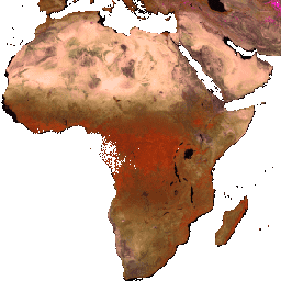
This dataset provides MODIS 3-year Nadir BRDF-Adjusted Reflectance (NBAR) mosaics from 2002 to 2017 with a 463-meter pixel size.
-
The mosaics are created using the MODIS 8-Day 500 meter BRDF-Albedo Quality product, selecting the best observations over a 3-year period.
-
The dataset includes seven Nadir Reflectance bands at local solar noon with different wavelength ranges.
-
MODIS data acquired through the LP DAAC has no restrictions on subsequent use, sale, or redistribution.
-
This dataset has been used to generate aboveground biomass/carbon maps and for capacity building in tropical countries.
- Dataset Availability
- 2002-01-01T00:00:00Z–2017-01-01T00:00:00Z
- Dataset Producer
- Baccini, A. (Woods Hole Research Center), Sulla-Menashe, D. (Boston University)
- Cadence
- 1 Year
- Tags
Description
The mosaics are created by using the MODIS 8-Day 500 meter BRDF-Albedo Quality product. Data Quality flags are used to select the best observations from the MODIS 8-day 500 meter Nadir BRDF-Adjusted Reflectance imagery product. This specific mosaic picks observations from the three highest quality categories over a 3-year period of MODIS data.
The MODIS NBAR annual mosaics have been used by government agencies and NGOs in tropical countries as input to generate aboveground biomass/carbon maps. The Woods Hole Research Center has been using the dataset for country capacity building and technical training workshops in tropical countries.
Bands
Bands
Pixel size: 463 meters (all bands)
| Name | Pixel Size | Wavelength | Description |
|---|---|---|---|
Nadir_Reflectance_Band1 |
463 meters | 620-670nm | Best NBAR at local solar noon for band 1 |
Nadir_Reflectance_Band2 |
463 meters | 841-876nm | Best NBAR at local solar noon for band 2 |
Nadir_Reflectance_Band3 |
463 meters | 459-479nm | Best NBAR at local solar noon for band 3 |
Nadir_Reflectance_Band4 |
463 meters | 545-565nm | Best NBAR at local solar noon for band 4 |
Nadir_Reflectance_Band5 |
463 meters | 1230-1250nm | Best NBAR at local solar noon for band 5 |
Nadir_Reflectance_Band6 |
463 meters | 1628-1652nm | Best NBAR at local solar noon for band 6 |
Nadir_Reflectance_Band7 |
463 meters | 2105-2155nm | Best NBAR at local solar noon for band 7 |
Terms of Use
Terms of Use
MODIS data and products acquired through the LP DAAC have no restrictions on subsequent use, sale, or redistribution.
Citations
Baccini, A., Laporte, N., Goetz, S. J., Sun, M., & Dong, H. (2008). A first map of tropical Africa's above-ground biomass derived from satellite imagery. Environmental Research Letters, 3(4), 045011. doi:10.1088/1748-9326/3/4/045011
DOIs
Explore with Earth Engine
Code Editor (JavaScript)
var dataset = ee.ImageCollection('WHBU/NBAR_3YEAR');

Map.addLayer(dataset.mean(), {min:0, max:7000});