Page Summary
-
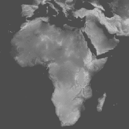
The GMTED2010 dataset provides global elevation data with a Breakline Emphasis and 7.5 arc-seconds resolution.
-
This dataset is a replacement for the GTOPO30 Elevation Model.
-
The primary source of data for GMTED2010 is void-filled SRTM data, supplemented by various other elevation datasets for areas outside SRTM coverage or with data gaps.
-
The band 'be75' represents elevation in meters.
- Dataset Availability
- 2010-01-01T00:00:00Z–2010-01-01T00:00:00Z
- Dataset Producer
- USGS
- Tags
Description
The Global Multi-resolution Terrain Elevation Data 2010 (GMTED2010) dataset contains elevation data for the globe collected from various sources. The version of the dataset available here is Breakline Emphasis, 7.5 arc-seconds resolution. Breakline emphasis maintains the critical topographic features (streams or ridges) within the landscape by maintaining any minimum elevation or maximum elevation value on a breakline that passes within the specified analysis window. More details are available in the dataset report.
The primary source dataset for GMTED2010 is NGA''s SRTM Digital Terrain Elevation Data (DTED®, https://www2.jpl.nasa.gov/srtm/) (void-filled) 1-arc-second data. For the geographic areas outside the SRTM coverage area and to fill in remaining holes in the SRTM data, the following sources were used: non-SRTM DTED®, Canadian Digital Elevation Data (CDED) at two resolutions, Satellite Pour l''Observation de la Terre (SPOT 5) Reference3D, National Elevation Dataset (NED) for the continental United States and Alaska, GEODATA 9 second digital elevation model (DEM) for Australia, an Antarctica satellite radar and laser altimeter DEM, and a Greenland satellite radar altimeter DEM.
This dataset replaces the GTOPO30 Elevation Model.
Bands
Bands
Pixel size: 231.92 meters (all bands)
| Name | Units | Min | Max | Pixel Size | Description |
|---|---|---|---|---|---|
be75 |
m | -457* | 8746* | 231.92 meters | Elevation |
Terms of Use
Terms of Use
Most U.S. Geological Survey (USGS) information resides in the public domain and may be used without restriction. Additional information on Acknowledging or Crediting USGS as Information Source is available.
Citations
Global Multi-resolution Terrain Elevation Data 2010 courtesy of the U.S. Geological Survey
Explore with Earth Engine
Code Editor (JavaScript)
var dataset = ee.Image('USGS/GMTED2010');
var elevation = dataset.select('be75');
var elevationVis = {
  min: -100.0,
  max: 6500.0,
  gamma: 3.5,
};
Map.setCenter(17.93, 7.71, 2);
Map.addLayer(elevation, elevationVis, 'Elevation');