- ডেটাসেটের প্রাপ্যতা
- 1985-01-01T00:00:00Z–2022-12-31T00:00:00Z
- ডেটাসেট প্রযোজক
- ইউএসডিএ ফরেস্ট সার্ভিস (ইউএসএফএস) ভূ-স্থানিক প্রযুক্তি ও প্রয়োগ কেন্দ্র (জিটিএসি)
- ট্যাগ
- পরিবর্তন
বর্ণনা
এই পণ্যটি ল্যান্ডস্কেপ চেঞ্জ মনিটরিং সিস্টেম (LCMS) ডেটা স্যুটের একটি অংশ। এটি CONUS এবং OCONUS জুড়ে প্রতিটি বছরের জন্য LCMS-মডেলকৃত পরিবর্তন, ভূমি আচ্ছাদন এবং/অথবা ভূমি ব্যবহারের শ্রেণিবিভাগ দেখায়।
এলসিএমএস হলো মার্কিন যুক্তরাষ্ট্র জুড়ে ভূদৃশ্য পরিবর্তনের মানচিত্র তৈরি ও পর্যবেক্ষণের জন্য একটি রিমোট সেন্সিং-ভিত্তিক ব্যবস্থা। এর উদ্দেশ্য হলো পরিবর্তন শনাক্তকরণের ক্ষেত্রে সর্বশেষ প্রযুক্তি ও অগ্রগতি ব্যবহার করে একটি সুসংগত পদ্ধতি তৈরি করা, যার মাধ্যমে ভূদৃশ্য পরিবর্তনের একটি 'সর্বোত্তম উপলব্ধ' মানচিত্র প্রস্তুত করা যাবে।
আউটপুটগুলির মধ্যে তিনটি বার্ষিক পণ্য অন্তর্ভুক্ত রয়েছে: পরিবর্তন, ভূমি আচ্ছাদন এবং ভূমি ব্যবহার। পরিবর্তন বিশেষভাবে উদ্ভিদ আচ্ছাদনের সাথে সম্পর্কিত এবং এর মধ্যে রয়েছে ধীর হ্রাস, দ্রুত হ্রাস (যার মধ্যে প্লাবন বা শুষ্কতার মতো জলবিদ্যুৎ সংক্রান্ত পরিবর্তনও অন্তর্ভুক্ত), এবং বৃদ্ধি। এই মানগুলি ল্যান্ডস্যাট টাইম সিরিজের প্রতিটি বছরের জন্য পূর্বাভাস করা হয় এবং LCMS-এর ভিত্তিগত পণ্য হিসাবে কাজ করে। ভূমি আচ্ছাদন এবং ভূমি ব্যবহারের মানচিত্রগুলি প্রতিটি বছরের জন্য জীবন-রূপ স্তরের ভূমি আচ্ছাদন এবং বৃহত্তর স্তরের ভূমি ব্যবহার চিত্রিত করে।
যেহেতু কোনো অ্যালগরিদমই সব পরিস্থিতিতে সেরা ফল দেয় না, তাই LCMS ভবিষ্যদ্বাণীকারী হিসেবে একাধিক মডেলের একটি সমাহার ব্যবহার করে, যা বিভিন্ন বাস্তুতন্ত্র এবং পরিবর্তন প্রক্রিয়া জুড়ে মানচিত্রের নির্ভুলতা উন্নত করে (হিলি এট আল., ২০১৮)। এর ফলে প্রাপ্ত LCMS-এর পরিবর্তন, ভূমি আচ্ছাদন এবং ভূমি ব্যবহারের মানচিত্রগুচ্ছ গত চার দশকে মার্কিন যুক্তরাষ্ট্র জুড়ে ভূদৃশ্য পরিবর্তনের একটি সামগ্রিক চিত্র তুলে ধরে।
LCMS মডেলের প্রেডিক্টর লেয়ারগুলোতে LandTrendr ও CCDC পরিবর্তন শনাক্তকরণ অ্যালগরিদমের আউটপুট এবং ভূখণ্ডের তথ্য অন্তর্ভুক্ত থাকে। এই সমস্ত উপাদান Google Earth Engine (Gorelick et al., 2017) ব্যবহার করে অ্যাক্সেস ও প্রসেস করা হয়।
CCDC-এর জন্য, CONUS-এর ক্ষেত্রে ইউনাইটেড স্টেটস জিওলজিক্যাল সার্ভে (USGS) কালেকশন ২ ল্যান্ডস্যাট টিয়ার ১ ভূপৃষ্ঠ প্রতিফলন ডেটা এবং SEAK, PRUSVI ও HI-এর ক্ষেত্রে ল্যান্ডস্যাট টিয়ার ১ টপ অফ অ্যাটমোস্ফিয়ার প্রতিফলন ডেটা ব্যবহার করা হয়েছিল। LandTrendr-এর জন্য বার্ষিক কম্পোজিট তৈরি করতে, USGS কালেকশন ২ ল্যান্ডস্যাট টিয়ার ১ এবং সেন্টিনেল ২এ, ২বি লেভেল-১সি টপ অফ অ্যাটমোস্ফিয়ার প্রতিফলন ডেটা ব্যবহার করা হয়েছিল। মেঘ মাস্ক করার জন্য cFmask ক্লাউড মাস্কিং অ্যালগরিদম (Foga et al., 2017), যা Fmask 2.0 (Zhu and Woodcock, 2012)-এর একটি বাস্তবায়ন (শুধুমাত্র ল্যান্ডস্যাটের জন্য), cloudScore (Chastain et al., 2019) (শুধুমাত্র ল্যান্ডস্যাটের জন্য), এবং s2cloudless (Sentinel-Hub, 2021) (শুধুমাত্র সেন্টিনেল ২-এর জন্য) ব্যবহৃত হয়, অন্যদিকে মেঘের ছায়া মাস্ক করার জন্য TDOM (Chastain et al., 2019) ব্যবহৃত হয় (ল্যান্ডস্যাট এবং সেন্টিনেল ২-এর জন্য)। এরপর LandTrendr-এর জন্য, প্রতিটি বছরের মেঘ এবং মেঘের ছায়ামুক্ত মানগুলোকে একটি একক কম্পোজিটে সংক্ষিপ্ত করার জন্য বার্ষিক মেডয়েড গণনা করা হয়।
ল্যান্ডট্রেন্ডার (কেনেডি ও অন্যান্য, ২০১০; কেনেডি ও অন্যান্য, ২০১৮; কোহেন ও অন্যান্য, ২০১৮) ব্যবহার করে যৌগিক সময় সিরিজটিকে সাময়িকভাবে বিভক্ত করা হয়েছে।
CCDC অ্যালগরিদম (Zhu and Woodcock, 2014) ব্যবহার করে সমস্ত মেঘ এবং মেঘছায়ামুক্ত মানগুলিকেও সাময়িকভাবে বিভক্ত করা হয়।
একটি র্যান্ডম ফরেস্ট (ব্রেইম্যান, ২০০১) মডেলে স্বাধীন ভবিষ্যদ্বাণীকারী চলক হিসেবে ১০ মিটার ইউএসজিএস ৩ডি এলিভেশন প্রোগ্রাম (৩ডিইপি) ডেটা (ইউএস জিওলজিক্যাল সার্ভে, ২০১৯) থেকে প্রাপ্ত কাঁচা কম্পোজিট মান, ল্যান্ডট্রেন্ডার ফিটেড মান, জোড়ায় জোড়ায় পার্থক্য, সেগমেন্টের সময়কাল, পরিবর্তনের মাত্রা ও ঢাল, এবং সিসিডিসি সেপ্টেম্বর ১-এর সাইন ও কোসাইন সহগ (প্রথম ৩টি হারমোনিক), ফিটেড মান ও জোড়ায় জোড়ায় পার্থক্য, এর সাথে উচ্চতা, ঢাল, অ্যাস্পেক্টের সাইন, অ্যাস্পেক্টের কোসাইন এবং টপোগ্রাফিক অবস্থান সূচক (ওয়েইস, ২০০১) ব্যবহার করা হয়েছে।
রেফারেন্স ডেটা সংগ্রহ করা হয় টাইমসিঙ্ক (TimeSync) নামক একটি ওয়েব-ভিত্তিক টুলের মাধ্যমে, যা বিশ্লেষকদের ১৯৮৪ সাল থেকে বর্তমান পর্যন্ত ল্যান্ডস্যাট ডেটা রেকর্ডকে দৃশ্যমান করতে ও ব্যাখ্যা করতে সাহায্য করে (কোয়েন প্রমুখ, ২০১০)।
অতিরিক্ত সম্পদ
এলসিএমএস ডেটা এক্সপ্লোরার হলো একটি ওয়েব-ভিত্তিক অ্যাপ্লিকেশন, যা ব্যবহারকারীদের এলসিএমএস ডেটা দেখা, বিশ্লেষণ করা, সারসংক্ষেপ করা এবং ডাউনলোড করার সুযোগ দেয়।
পদ্ধতি এবং নির্ভুলতা মূল্যায়ন সম্পর্কিত আরও বিস্তারিত তথ্যের জন্য অনুগ্রহ করে LCMS মেথডস ব্রিফ দেখুন, অথবা ডেটা ডাউনলোড, মেটাডেটা এবং সহায়ক নথিপত্রের জন্য LCMS জিওডেটা ক্লিয়ারিংহাউস দেখুন ।
যেকোনো প্রশ্ন বা নির্দিষ্ট তথ্যের অনুরোধের জন্য [sm.fs.lcms@usda.gov] -এ যোগাযোগ করুন।
ব্রেইম্যান, এল., ২০০১। র্যান্ডম ফরেস্ট। মেশিন লার্নিং-এ। স্প্রিংগার , ৪৫: ৫-৩২ doi:10.1023/A:1010933404324
চ্যাস্টেইন, আর., হাউসম্যান, আই., গোল্ডস্টেইন, জে., ফিনকো, এম., এবং টেনেসন, কে., ২০১৯। মার্কিন যুক্তরাষ্ট্রের সংলগ্ন অঞ্চলের উপর সেন্টিনেল-২এ ও ২বি এমএসআই, ল্যান্ডস্যাট-৮ ওএলআই, এবং ল্যান্ডস্যাট-৭ ইটিএম-এর বায়ুমণ্ডলের শীর্ষভাগের বর্ণালীগত বৈশিষ্ট্যের প্রায়োগিক আন্তঃসেন্সর তুলনা। রিমোট সেন্সিং অফ এনভায়রনমেন্ট-এ। সায়েন্স ডাইরেক্ট , ২২১: ২৭৪-২৮৫ doi:10.1016/j.rse.2018.11.012
কোহেন, ডব্লিউবি, ইয়াং, জেড., এবং কেনেডি, আর., ২০১০। বার্ষিক ল্যান্ডস্যাট টাইম সিরিজ ব্যবহার করে বনভূমির ব্যাঘাত এবং পুনরুদ্ধারের প্রবণতা সনাক্তকরণ: ২. টাইমসিঙ্ক - ক্রমাঙ্কন এবং বৈধকরণের জন্য সরঞ্জাম। রিমোট সেন্সিং অফ এনভায়রনমেন্ট-এ। সায়েন্স ডাইরেক্ট , 114(12): 2911-2924 doi:10.1016/j.rse.2010.07.010
কোহেন, ডব্লিউবি, ইয়াং, জেড., হিলি, এসপি, কেনেডি, আরই, এবং গোরলিক, এন., ২০১৮। বনভূমির বিপর্যয় শনাক্তকরণের জন্য একটি ল্যান্ডট্রেন্ডার মাল্টিস্পেকট্রাল এনসেম্বল। রিমোট সেন্সিং অফ এনভায়রনমেন্ট-এ। সায়েন্স ডাইরেক্ট , ২০৫: ১৩১-১৪০ doi:10.1016/j.rse.2017.11.015
ফোগা, এস., স্কারামুজা, পিএল, গুও, এস., ঝু, জেড., ডিলে, আরডি, বেকম্যান, টি., শ্মিট, জিএল, ডায়ার, জেএল, হিউজেস, এমজে, লাউ, বি., ২০১৭। অপারেশনাল ল্যান্ডস্যাট ডেটা প্রোডাক্টের জন্য মেঘ শনাক্তকরণ অ্যালগরিদমের তুলনা ও বৈধতা। রিমোট সেন্সিং অফ এনভায়রনমেন্ট-এ। সায়েন্স ডাইরেক্ট , ১৯৪: ৩৭৯-৩৯০ doi:10.1016/j.rse.2017.03.026
ইউএস জিওলজিক্যাল সার্ভে, ২০১৯। ইউএসজিএস ৩ডি এলিভেশন প্রোগ্রাম ডিজিটাল এলিভেশন মডেল, আগস্ট ২০২২-এ https://developers.google.com/earth-engine/datasets/catalog/USGS_3DEP_10m থেকে সংগৃহীত।
হিলি, এসপি, কোহেন, ডব্লিউবি, ইয়াং, জেড., কেনেথ ব্রুয়ার, সি., ব্রুকস, ইবি, গোরলিক, এন., হার্নান্দেজ, এজে, হুয়াং, সি., জোসেফ হিউজেস, এম., কেনেডি, আরই, লাভল্যান্ড, টিআর, ময়েসেন, জিজি, শ্রোডার, টিএ, স্টেহম্যান, এসভি, ভোগেলম্যান, জেই, উডকক, সিই, ইয়াং, এল., এবং ঝু, জেড., ২০১৮। স্ট্যাকড জেনারেলাইজেশন ব্যবহার করে বন পরিবর্তনের মানচিত্রায়ন: একটি এনসেম্বল পদ্ধতি। রিমোট সেন্সিং অফ এনভায়রনমেন্ট-এ। সায়েন্স ডাইরেক্ট , ২০৪: ৭১৭-৭২৮ doi:10.1016/j.rse.2017.09.029
কেনেডি, আর.ই., ইয়াং, জেড., এবং কোহেন, ডব্লিউ.বি., ২০১০। বার্ষিক ল্যান্ডস্যাট টাইম সিরিজ ব্যবহার করে বনভূমির ব্যাঘাত এবং পুনরুদ্ধারের প্রবণতা সনাক্তকরণ: ১. ল্যান্ডট্রেন্ডার - টেম্পোরাল সেগমেন্টেশন অ্যালগরিদম। রিমোট সেন্সিং অফ এনভায়রনমেন্ট-এ। সায়েন্স ডাইরেক্ট , ১১৪(১২): ২৮৯৭-২৯১০ doi:10.1016/j.rse.2010.07.008
কেনেডি, আর., ইয়াং, জেড., গোরলিক, এন., ব্রাটেন, জে., ক্যাভালকান্তে, এল., কোহেন, ডব্লিউ., এবং হিলি, এস., 2018। গুগল আর্থ ইঞ্জিনে ল্যান্ডট্রেন্ডার অ্যালগরিদমের বাস্তবায়ন। রিমোট সেন্সিং-এ। এমডিপিআই , 10(5): 691 doi:10.3390/rs10050691
সেন্টিনেল-হাব, ২০২১। সেন্টিনেল ২ ক্লাউড ডিটেক্টর। [অনলাইন]। এখানে উপলব্ধ: https://github.com/sentinel-hub/sentinel2-cloud-detector
ওয়েইস, এডি, ২০০১। ভূসংস্থানিক অবস্থান এবং ভূমিরূপ বিশ্লেষণ পোস্টার উপস্থাপনা, ইএসআরআই ব্যবহারকারী সম্মেলন, সান ডিয়েগো, সিএ। জু, জেড., এবং উডকক, সিই (২০১২)। ল্যান্ডস্যাট চিত্রে বস্তু-ভিত্তিক মেঘ এবং মেঘের ছায়া সনাক্তকরণ। ১১৮: ৮৩-৯৪।
ঝু, জেড., এবং উডকক, সিই, ২০১২। ল্যান্ডস্যাট চিত্রাবলীতে বস্তু-ভিত্তিক মেঘ এবং মেঘের ছায়া শনাক্তকরণ। রিমোট সেন্সিং অফ এনভায়রনমেন্ট-এ। সায়েন্স ডাইরেক্ট , ১১৮: ৮৩-৯৪ doi:10.1016/j.rse.2011.10.028
ঝু, জেড., এবং উডকক, সিই, ২০১৪। সকল উপলব্ধ ল্যান্ডস্যাট ডেটা ব্যবহার করে ভূমি আবরণের ধারাবাহিক পরিবর্তন শনাক্তকরণ ও শ্রেণিবিন্যাস। রিমোট সেন্সিং অফ এনভায়রনমেন্ট-এ। সায়েন্স ডাইরেক্ট , ১৪৪: ১৫২-১৭১ doi:10.1016/j.rse.2014.01.011
ব্যান্ড
ব্যান্ড
পিক্সেল সাইজ: ৩০ মিটার (সকল ব্যান্ড)
| নাম | পিক্সেল আকার | বর্ণনা | |||||||||||||||||||||||||||||||||||||||||||||||||||||||||||||||||||||||||||||||||||||||||||||||||
|---|---|---|---|---|---|---|---|---|---|---|---|---|---|---|---|---|---|---|---|---|---|---|---|---|---|---|---|---|---|---|---|---|---|---|---|---|---|---|---|---|---|---|---|---|---|---|---|---|---|---|---|---|---|---|---|---|---|---|---|---|---|---|---|---|---|---|---|---|---|---|---|---|---|---|---|---|---|---|---|---|---|---|---|---|---|---|---|---|---|---|---|---|---|---|---|---|---|---|---|
Change | ৩০ মিটার | চূড়ান্ত থিমেটিক LCMS পরিবর্তন ফলাফল। প্রতিটি বছরের জন্য মোট তিনটি পরিবর্তন শ্রেণি (ধীর হ্রাস, দ্রুত হ্রাস এবং বৃদ্ধি) ম্যাপ করা হয়। প্রতিটি শ্রেণি একটি পৃথক র্যান্ডম ফরেস্ট মডেল ব্যবহার করে পূর্বাভাস করা হয়, যা পিক্সেলটি সেই শ্রেণির অন্তর্ভুক্ত হওয়ার একটি সম্ভাবনা (র্যান্ডম ফরেস্ট মডেলের মধ্যে থাকা ট্রি-গুলোর অনুপাত) আউটপুট হিসেবে দেয়। এই কারণে, প্রতিটি পিক্সেলের জন্য প্রতি বছর তিনটি ভিন্ন মডেল আউটপুট থাকে। চূড়ান্ত শ্রেণিটি সেই পরিবর্তন শ্রেণিতে নির্ধারিত হয়, যার সম্ভাবনা সর্বোচ্চ এবং যা একটি নির্দিষ্ট থ্রেশহোল্ডের উপরে থাকে। যে কোনো পিক্সেল যার প্রতিটি শ্রেণির নিজ নিজ থ্রেশহোল্ডের উপরে কোনো মান নেই, তাকে স্থিতিশীল (Stable) শ্রেণিতে নির্ধারিত করা হয়। | |||||||||||||||||||||||||||||||||||||||||||||||||||||||||||||||||||||||||||||||||||||||||||||||||
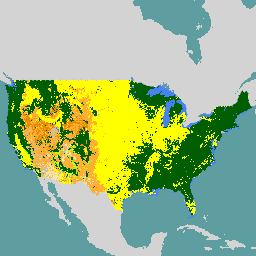
Land_Cover | ৩০ মিটার | চূড়ান্ত বিষয়ভিত্তিক LCMS ভূমি আচ্ছাদন পণ্য। TimeSync রেফারেন্স ডেটা এবং Landsat চিত্র থেকে প্রাপ্ত বর্ণালী তথ্য ব্যবহার করে বার্ষিক ভিত্তিতে মোট ১৪টি ভূমি আচ্ছাদন শ্রেণি ম্যাপ করা হয়। প্রতিটি শ্রেণি একটি পৃথক Random Forest মডেল ব্যবহার করে পূর্বাভাস করা হয়, যা পিক্সেলটি সেই শ্রেণির অন্তর্ভুক্ত হওয়ার একটি সম্ভাবনা (Random Forest মডেলের মধ্যে থাকা বৃক্ষগুলোর অনুপাত) আউটপুট হিসেবে দেয়। এই কারণে, প্রতিটি পিক্সেলের জন্য প্রতি বছর ১৪টি ভিন্ন মডেল আউটপুট থাকে এবং সর্বোচ্চ সম্ভাবনাসম্পন্ন ভূমি আচ্ছাদনটিকে চূড়ান্ত শ্রেণি হিসেবে নির্ধারণ করা হয়। ১৪টি ভূমি আচ্ছাদন শ্রেণির মধ্যে সাতটি একটি একক ভূমি আচ্ছাদন নির্দেশ করে, যেখানে সেই ভূমি আচ্ছাদন পিক্সেলের বেশিরভাগ এলাকা জুড়ে থাকে এবং অন্য কোনো শ্রেণি পিক্সেলের ১০%-এর বেশি অংশ জুড়ে থাকে না। এছাড়াও সাতটি মিশ্র শ্রেণি রয়েছে। এগুলো এমন পিক্সেলকে প্রতিনিধিত্ব করে যেখানে একটি অতিরিক্ত ভূমি আচ্ছাদন শ্রেণি পিক্সেলের অন্তত ১০% অংশ জুড়ে থাকে। | |||||||||||||||||||||||||||||||||||||||||||||||||||||||||||||||||||||||||||||||||||||||||||||||||
Land_Use | ৩০ মিটার | চূড়ান্ত বিষয়ভিত্তিক LCMS ভূমি ব্যবহার পণ্য। TimeSync রেফারেন্স ডেটা এবং Landsat চিত্র থেকে প্রাপ্ত বর্ণালী তথ্য ব্যবহার করে বার্ষিক ভিত্তিতে মোট ৬টি ভূমি ব্যবহার শ্রেণি ম্যাপ করা হয়। প্রতিটি শ্রেণি একটি পৃথক Random Forest মডেল ব্যবহার করে পূর্বাভাস করা হয়, যা পিক্সেলটি সেই শ্রেণির অন্তর্ভুক্ত হওয়ার একটি সম্ভাবনা (Random Forest মডেলের মধ্যে থাকা ট্রি-গুলোর অনুপাত) আউটপুট হিসেবে দেয়। এই কারণে, প্রতিটি পিক্সেলের জন্য প্রতি বছর ৬টি ভিন্ন মডেল আউটপুট থাকে এবং সর্বোচ্চ সম্ভাবনাসম্পন্ন ভূমি ব্যবহারকে চূড়ান্ত শ্রেণি হিসেবে নির্ধারণ করা হয়। | |||||||||||||||||||||||||||||||||||||||||||||||||||||||||||||||||||||||||||||||||||||||||||||||||
Change_Raw_Probability_Slow_Loss | ৩০ মিটার | LCMS দ্বারা মডেলকৃত স্লো লস-এর সম্ভাবনা। এর সংজ্ঞা হলো: টাইমসিঙ্ক পরিবর্তন প্রক্রিয়ার ব্যাখ্যা অনুসারে স্লো লস-এর মধ্যে নিম্নলিখিত শ্রেণিগুলো অন্তর্ভুক্ত-
| |||||||||||||||||||||||||||||||||||||||||||||||||||||||||||||||||||||||||||||||||||||||||||||||||
Change_Raw_Probability_Fast_Loss | ৩০ মিটার | LCMS দ্বারা মডেলকৃত ফাস্ট লস-এর সম্ভাবনা। এর সংজ্ঞা হলো: টাইমসিঙ্ক পরিবর্তন প্রক্রিয়ার ব্যাখ্যা অনুসারে ফাস্ট লস-এর মধ্যে নিম্নলিখিত শ্রেণিগুলো অন্তর্ভুক্ত-
| |||||||||||||||||||||||||||||||||||||||||||||||||||||||||||||||||||||||||||||||||||||||||||||||||
Change_Raw_Probability_Gain | ৩০ মিটার | কাঁচা LCMS মডেলকৃত বৃদ্ধির সম্ভাবনা। এর সংজ্ঞা হলো: এক বা একাধিক বছর ধরে বৃদ্ধি এবং অনুক্রমের কারণে উদ্ভিদ আচ্ছাদনের বৃদ্ধি প্রদর্শনকারী ভূমি। এটি এমন যেকোনো এলাকার জন্য প্রযোজ্য যেখানে উদ্ভিদের পুনরুজ্জীবনের সাথে সম্পর্কিত বর্ণালীগত পরিবর্তন প্রকাশ পেতে পারে। উন্নত এলাকায়, পরিপক্ক উদ্ভিদ এবং/অথবা নতুন স্থাপিত লন ও ল্যান্ডস্কেপিংয়ের ফলে বৃদ্ধি ঘটতে পারে। বনে, বৃদ্ধির মধ্যে অন্তর্ভুক্ত রয়েছে অনাবৃত ভূমি থেকে উদ্ভিদের বৃদ্ধি, সেইসাথে মধ্যবর্তী ও সহ-প্রভাবশালী গাছ এবং/অথবা নিচু ঘাস ও গুল্মকে ঢেকে ফেলা। বন কাটার পরে রেকর্ড করা বৃদ্ধি/পুনরুদ্ধার অংশগুলো বনের পুনরুজ্জীবনের সাথে সাথে বিভিন্ন ভূমি আচ্ছাদন শ্রেণীর মধ্য দিয়ে পরিবর্তিত হতে পারে। এই পরিবর্তনগুলোকে বৃদ্ধি/পুনরুদ্ধার হিসেবে বিবেচনা করার জন্য, বর্ণালীগত মানগুলোকে একটি ক্রমবর্ধমান প্রবণতা রেখার (যেমন একটি ধনাত্মক ঢাল যা প্রায় ২০ বছর পর্যন্ত প্রসারিত হলে NDVI-এর .১০ এককের মতো হবে) সাথে ঘনিষ্ঠভাবে সামঞ্জস্যপূর্ণ হতে হবে, যা বেশ কয়েক বছর ধরে স্থায়ী থাকে। | |||||||||||||||||||||||||||||||||||||||||||||||||||||||||||||||||||||||||||||||||||||||||||||||||
Land_Cover_Raw_Probability_Trees | ৩০ মিটার | LCMS মডেল অনুযায়ী গাছের সম্ভাব্যতার কাঁচা মান। এর সংজ্ঞা হলো: পিক্সেলের অধিকাংশ অংশ জীবন্ত অথবা দণ্ডায়মান মৃত গাছ দ্বারা গঠিত। | |||||||||||||||||||||||||||||||||||||||||||||||||||||||||||||||||||||||||||||||||||||||||||||||||
Land_Cover_Raw_Probability_Tall-Shrubs-and-Trees-Mix | ৩০ মিটার | লম্বা গুল্ম ও গাছের মিশ্রণের (শুধুমাত্র SEAK-এর জন্য) LCMS মডেল অনুযায়ী প্রাপ্ত সম্ভাব্যতা। এর সংজ্ঞা হলো: পিক্সেলের বেশিরভাগ অংশ ১ মিটারের বেশি উচ্চতার গুল্ম দ্বারা গঠিত এবং এতে কমপক্ষে ১০% জীবিত বা দণ্ডায়মান মৃত গাছ রয়েছে। | |||||||||||||||||||||||||||||||||||||||||||||||||||||||||||||||||||||||||||||||||||||||||||||||||
Land_Cover_Raw_Probability_Shrubs-and-Trees-Mix | ৩০ মিটার | LCMS মডেল অনুযায়ী গুল্ম ও বৃক্ষের মিশ্রণের সম্ভাব্যতা। এর সংজ্ঞা হলো: পিক্সেলের অধিকাংশ অংশ গুল্ম দ্বারা গঠিত এবং এতে কমপক্ষে ১০% জীবিত বা দণ্ডায়মান মৃত গাছও রয়েছে। | |||||||||||||||||||||||||||||||||||||||||||||||||||||||||||||||||||||||||||||||||||||||||||||||||
Land_Cover_Raw_Probability_Grass-Forb-Herb-and-Trees-Mix | ৩০ মিটার | ঘাস/গুল্ম/ভেষজ এবং গাছের মিশ্রণের LCMS মডেলকৃত কাঁচা সম্ভাবনা। এর সংজ্ঞা হলো: পিক্সেলের বেশিরভাগ অংশ বহুবর্ষজীবী ঘাস, গুল্ম বা অন্যান্য ধরনের তৃণজাতীয় উদ্ভিদ দ্বারা গঠিত এবং এতে কমপক্ষে ১০% জীবিত বা দণ্ডায়মান মৃত গাছও রয়েছে। | |||||||||||||||||||||||||||||||||||||||||||||||||||||||||||||||||||||||||||||||||||||||||||||||||
Land_Cover_Raw_Probability_Barren-and-Trees-Mix | ৩০ মিটার | LCMS মডেল অনুযায়ী অনুর্বর এবং বৃক্ষ মিশ্রণের সম্ভাব্যতা। এর সংজ্ঞা হলো: পিক্সেলের বেশিরভাগ অংশই বিঘ্নের ফলে উন্মুক্ত হওয়া অনাবৃত মাটি (যেমন, যান্ত্রিকভাবে পরিষ্কার করা বা বন কাটার ফলে উন্মোচিত মাটি) এবং সেইসাথে চিরস্থায়ীভাবে অনুর্বর এলাকা যেমন মরুভূমি, প্লায়া, শিলা উন্মোচন (ভূ-পৃষ্ঠ খনন কার্যক্রমের ফলে উন্মোচিত খনিজ এবং অন্যান্য ভূতাত্ত্বিক উপাদান সহ), বালিয়াড়ি, লবণাক্ত সমভূমি এবং সৈকত দ্বারা গঠিত। মাটি ও নুড়ি দিয়ে তৈরি রাস্তাও অনুর্বর হিসাবে বিবেচিত হয় এবং এতে কমপক্ষে ১০% জীবিত বা দণ্ডায়মান মৃত গাছ থাকে। | |||||||||||||||||||||||||||||||||||||||||||||||||||||||||||||||||||||||||||||||||||||||||||||||||
Land_Cover_Raw_Probability_Tall-Shrubs | ৩০ মিটার | কাঁচা LCMS মডেলকৃত লম্বা গুল্মের সম্ভাবনা (শুধুমাত্র SEAK-এর জন্য)। এর সংজ্ঞা হলো: পিক্সেলের অধিকাংশ অংশ ১ মিটারের বেশি উচ্চতার গুল্ম দ্বারা গঠিত। | |||||||||||||||||||||||||||||||||||||||||||||||||||||||||||||||||||||||||||||||||||||||||||||||||
Land_Cover_Raw_Probability_Shrubs | ৩০ মিটার | LCMS মডেল অনুযায়ী গুল্মের সম্ভাব্যতা। এর সংজ্ঞা হলো: পিক্সেলের অধিকাংশ অংশ গুল্ম দ্বারা গঠিত। | |||||||||||||||||||||||||||||||||||||||||||||||||||||||||||||||||||||||||||||||||||||||||||||||||
Land_Cover_Raw_Probability_Grass-Forb-Herb-and-Shrubs-Mix | ৩০ মিটার | ঘাস/গুল্ম/ভেষজ এবং গুল্মের মিশ্রণের কাঁচা LCMS মডেলকৃত সম্ভাবনা। এর সংজ্ঞা হলো: পিক্সেলের বেশিরভাগ অংশ বহুবর্ষজীবী ঘাস, গুল্ম বা অন্যান্য ধরনের তৃণজাতীয় উদ্ভিদ দ্বারা গঠিত এবং এতে কমপক্ষে ১০% গুল্মও রয়েছে। | |||||||||||||||||||||||||||||||||||||||||||||||||||||||||||||||||||||||||||||||||||||||||||||||||
Land_Cover_Raw_Probability_Barren-and-Shrubs-Mix | ৩০ মিটার | LCMS মডেল অনুযায়ী অনুর্বর ও গুল্মের মিশ্রণের সম্ভাব্যতা। এর সংজ্ঞা হলো: পিক্সেলের বেশিরভাগ অংশই বিঘ্নের ফলে উন্মুক্ত হওয়া অনাবৃত মাটি (যেমন, যান্ত্রিকভাবে পরিষ্কার করা বা বন কাটার ফলে উন্মোচিত মাটি) এবং সেইসাথে চিরস্থায়ীভাবে অনুর্বর এলাকা, যেমন—মরুভূমি, প্লায়া, শিলাস্তূপ (ভূ-পৃষ্ঠ খনন কার্যক্রমের ফলে উন্মোচিত খনিজ এবং অন্যান্য ভূতাত্ত্বিক উপাদান সহ), বালিয়াড়ি, লবণাক্ত সমভূমি এবং সৈকত দ্বারা গঠিত। মাটি ও নুড়ি দিয়ে তৈরি রাস্তাও অনুর্বর হিসেবে বিবেচিত হয় এবং এতেও কমপক্ষে ১০% গুল্ম থাকে। | |||||||||||||||||||||||||||||||||||||||||||||||||||||||||||||||||||||||||||||||||||||||||||||||||
Land_Cover_Raw_Probability_Grass-Forb-Herb | ৩০ মিটার | LCMS মডেল অনুযায়ী ঘাস/গুল্ম/ভেষজের কাঁচা সম্ভাবনা। এর সংজ্ঞা হলো: পিক্সেলের বেশিরভাগ অংশ বহুবর্ষজীবী ঘাস, গুল্ম বা অন্যান্য ধরনের তৃণজাতীয় উদ্ভিদ দ্বারা গঠিত। | |||||||||||||||||||||||||||||||||||||||||||||||||||||||||||||||||||||||||||||||||||||||||||||||||
Land_Cover_Raw_Probability_Barren-and-Grass-Forb-Herb-Mix | ৩০ মিটার | LCMS দ্বারা মডেলকৃত অনুর্বর এবং ঘাস/গুল্ম/ভেষজ উদ্ভিদের মিশ্রণের সম্ভাব্যতা। এর সংজ্ঞা হলো: পিক্সেলের বেশিরভাগ অংশই বিঘ্নের ফলে উন্মুক্ত হওয়া অনাবৃত মাটি (যেমন, যান্ত্রিকভাবে পরিষ্কার করা বা বন কাটার ফলে উন্মোচিত মাটি) দ্বারা গঠিত, সেইসাথে মরুভূমি, প্লায়া, শিলা উন্মোচন (ভূ-পৃষ্ঠ খনন কার্যক্রমের ফলে উন্মোচিত খনিজ এবং অন্যান্য ভূতাত্ত্বিক উপাদান সহ), বালিয়াড়ি, লবণাক্ত সমভূমি এবং সৈকতের মতো চিরস্থায়ী অনুর্বর এলাকা। মাটি ও নুড়ি দিয়ে তৈরি রাস্তাও অনুর্বর বলে বিবেচিত হয় এবং এতে কমপক্ষে ১০% বহুবর্ষজীবী ঘাস, গুল্ম বা অন্যান্য ধরনের তৃণজাতীয় উদ্ভিদ থাকে। | |||||||||||||||||||||||||||||||||||||||||||||||||||||||||||||||||||||||||||||||||||||||||||||||||
Land_Cover_Raw_Probability_Barren-or-Impervious | ৩০ মিটার | LCMS দ্বারা মডেলকৃত অনুর্বর বা অভেদ্য হওয়ার সম্ভাবনা। এর সংজ্ঞা হলো: পিক্সেলের বেশিরভাগ অংশ গঠিত হয় ১) প্রাকৃতিক বিঘ্নের ফলে উন্মুক্ত হওয়া অনাবৃত মাটি (যেমন, যান্ত্রিকভাবে পরিষ্কার করা বা বন কাটার ফলে উন্মোচিত মাটি), সেইসাথে চিরস্থায়ীভাবে অনুর্বর এলাকা যেমন মরুভূমি, প্লায়া, শিলাস্তূপ (ভূ-পৃষ্ঠ খনন কার্যক্রমের ফলে উন্মোচিত খনিজ এবং অন্যান্য ভূতাত্ত্বিক উপাদান সহ), বালিয়াড়ি, লবণাক্ত সমভূমি এবং সৈকত দ্বারা। মাটি ও নুড়ি পাথরের তৈরি রাস্তাও অনুর্বর বলে বিবেচিত হয় অথবা ২) মানুষের তৈরি উপাদান যা ভেদ করতে পারে না, যেমন পাকা রাস্তা, ছাদ এবং পার্কিং লট। | |||||||||||||||||||||||||||||||||||||||||||||||||||||||||||||||||||||||||||||||||||||||||||||||||
Land_Cover_Raw_Probability_Snow-or-Ice | ৩০ মিটার | LCMS মডেল অনুযায়ী তুষার বা বরফের সম্ভাবনা। এর সংজ্ঞা হলো: পিক্সেলের বেশিরভাগ অংশ তুষার বা বরফ দ্বারা গঠিত। | |||||||||||||||||||||||||||||||||||||||||||||||||||||||||||||||||||||||||||||||||||||||||||||||||
Land_Cover_Raw_Probability_Water | ৩০ মিটার | কাঁচা LCMS মডেল অনুযায়ী পানির সম্ভাব্যতা। এর সংজ্ঞা হলো: পিক্সেলের সিংহভাগ পানি দ্বারা গঠিত। | |||||||||||||||||||||||||||||||||||||||||||||||||||||||||||||||||||||||||||||||||||||||||||||||||
Land_Use_Raw_Probability_Agriculture | ৩০ মিটার | এলসিএমএস মডেল অনুযায়ী কৃষির সম্ভাব্যতার প্রাথমিক চিত্র। এর সংজ্ঞা হলো: খাদ্য, তন্তু এবং জ্বালানি উৎপাদনের জন্য ব্যবহৃত জমি, যা উদ্ভিদ আচ্ছাদিত বা উদ্ভিদবিহীন উভয় অবস্থাতেই থাকতে পারে। এর মধ্যে অন্তর্ভুক্ত কিন্তু সীমাবদ্ধ নয়: চাষ করা ও চাষ না করা শস্যভূমি, খড়ের জমি, ফলের বাগান, আঙুরের বাগান, আবদ্ধ পশুপালন কেন্দ্র এবং ফল, বাদাম বা বেরি উৎপাদনের জন্য রোপিত এলাকা। যে রাস্তাগুলো প্রধানত কৃষি কাজে ব্যবহৃত হয় (অর্থাৎ শহর থেকে শহরে গণপরিবহনের জন্য ব্যবহৃত হয় না), সেগুলোকে কৃষি জমি হিসেবে গণ্য করা হয়। | |||||||||||||||||||||||||||||||||||||||||||||||||||||||||||||||||||||||||||||||||||||||||||||||||
Land_Use_Raw_Probability_Developed | ৩০ মিটার | এলসিএমএস মডেল অনুযায়ী উন্নত হওয়ার সম্ভাবনা। এর সংজ্ঞা হলো: মনুষ্যসৃষ্ট কাঠামো (যেমন, উচ্চ ঘনত্বের আবাসিক, বাণিজ্যিক, শিল্প, খনি বা পরিবহন) দ্বারা আচ্ছাদিত ভূমি, অথবা গাছপালা (গাছ সহ) এবং কাঠামোর (যেমন, নিম্ন ঘনত্বের আবাসিক এলাকা, লন, বিনোদন কেন্দ্র, কবরস্থান, পরিবহন ও পরিষেবা করিডোর ইত্যাদি) মিশ্রণ, যার মধ্যে মানুষের কার্যকলাপ দ্বারা কার্যকারিতা পরিবর্তিত যেকোনো ভূমিও অন্তর্ভুক্ত। | |||||||||||||||||||||||||||||||||||||||||||||||||||||||||||||||||||||||||||||||||||||||||||||||||
Land_Use_Raw_Probability_Forest | ৩০ মিটার | এলসিএমএস মডেল অনুযায়ী বনের সম্ভাব্যতার প্রাথমিক মান। এর সংজ্ঞা হলো: এমন ভূমি যা রোপিত বা প্রাকৃতিকভাবে গাছপালা দ্বারা আবৃত এবং যেখানে নিকট ভবিষ্যতের কোনো ক্রমবিকাশমান ধারায় কোনো এক সময়ে ১০% বা তার বেশি বৃক্ষ আচ্ছাদন থাকে (বা থাকার সম্ভাবনা থাকে)। এর মধ্যে পর্ণমোচী, চিরসবুজ এবং/অথবা মিশ্র শ্রেণীর প্রাকৃতিক বন, বনভূমি এবং কাষ্ঠল জলাভূমি অন্তর্ভুক্ত থাকতে পারে। | |||||||||||||||||||||||||||||||||||||||||||||||||||||||||||||||||||||||||||||||||||||||||||||||||
Land_Use_Raw_Probability_Non-Forest-Wetland | ৩০ মিটার | অ-বন জলাভূমির কাঁচা LCMS মডেলকৃত সম্ভাবনা। এর সংজ্ঞা হলো: দৃশ্যমান জলস্তরের (স্থায়ীভাবে বা ঋতুগতভাবে সম্পৃক্ত) সংলগ্ন বা তার মধ্যে অবস্থিত এমন ভূমি, যা গুল্ম বা স্থায়ী জলজ উদ্ভিদ দ্বারা প্রভাবিত। এই জলাভূমিগুলো হ্রদ, নদীখাত বা মোহনার তীরবর্তী অঞ্চলে; নদীর প্লাবনভূমিতে; বিচ্ছিন্ন জলাধার এলাকায়; বা ঢালে অবস্থিত হতে পারে। এগুলো কৃষিভূমিতে তৃণভূমির গর্ত, নিষ্কাশন নালা এবং পশুপালনের পুকুর হিসেবেও দেখা যেতে পারে এবং হ্রদ বা নদীর মাঝখানে দ্বীপ হিসেবেও আবির্ভূত হতে পারে। অন্যান্য উদাহরণের মধ্যে রয়েছে জলা, পিটভূমি, জলাভূমি, কাদাজমি, জলাশয়, জলাশয়, ফেন্স এবং খাঁড়ি। | |||||||||||||||||||||||||||||||||||||||||||||||||||||||||||||||||||||||||||||||||||||||||||||||||
Land_Use_Raw_Probability_Other | ৩০ মিটার | LCMS মডেল অনুযায়ী 'অন্যান্য'-এর সম্ভাবনা। এর সংজ্ঞা হলো: এমন ভূমি (ব্যবহার নির্বিশেষে) যেখানে বর্ণালীর প্রবণতা বা অন্যান্য সহায়ক প্রমাণ থেকে বোঝা যায় যে কোনো বিঘ্ন বা পরিবর্তনের ঘটনা ঘটেছে, কিন্তু এর সুনির্দিষ্ট কারণ নির্ণয় করা যায় না অথবা পরিবর্তনের ধরনটি উপরে সংজ্ঞায়িত পরিবর্তন প্রক্রিয়ার কোনো বিভাগের সাথে মেলে না। | |||||||||||||||||||||||||||||||||||||||||||||||||||||||||||||||||||||||||||||||||||||||||||||||||
Land_Use_Raw_Probability_Rangeland-or-Pasture | ৩০ মিটার | এলসিএমএস (LCMS) মডেল অনুযায়ী চারণভূমি বা তৃণভূমির সম্ভাব্যতা। এর সংজ্ঞা নিম্নরূপ: এই শ্রেণীর অন্তর্ভুক্ত এলাকাগুলো হলো ক) চারণভূমি, যেখানে উদ্ভিদকুল হলো দেশীয় ঘাস, গুল্ম, ভেষজ উদ্ভিদ এবং ঘাসের মতো উদ্ভিদের মিশ্রণ, যা মূলত বৃষ্টিপাত, তাপমাত্রা, উচ্চতা এবং অগ্নিকাণ্ডের মতো প্রাকৃতিক কারণ ও প্রক্রিয়ার ফলে সৃষ্টি হয়; যদিও সীমিত ব্যবস্থাপনার মধ্যে নিয়ন্ত্রিতভাবে আগুন লাগানো এবং গৃহপালিত ও বন্য তৃণভোজী প্রাণীদের দ্বারা চারণ অন্তর্ভুক্ত থাকতে পারে; অথবা খ) তৃণভূমি, যেখানে উদ্ভিদকুল মিশ্র, মূলত প্রাকৃতিক ঘাস, ভেষজ উদ্ভিদ ও গুল্ম থেকে শুরু করে এমন নিয়ন্ত্রিত উদ্ভিদকুল পর্যন্ত হতে পারে, যেখানে ঘাসের প্রজাতিগুলোর প্রাধান্য থাকে এবং যেগুলোকে প্রায় একক চাষ (মনোকালচার) বজায় রাখার জন্য বীজ বপন ও পরিচর্যা করা হয়। | |||||||||||||||||||||||||||||||||||||||||||||||||||||||||||||||||||||||||||||||||||||||||||||||||
QA_Bits | ৩০ মিটার | বার্ষিক LCMS পণ্য আউটপুট মানগুলির উৎস সম্পর্কিত আনুষঙ্গিক তথ্য। | |||||||||||||||||||||||||||||||||||||||||||||||||||||||||||||||||||||||||||||||||||||||||||||||||
শ্রেণী সারণী পরিবর্তন করুন
| মূল্য | রঙ | বর্ণনা |
|---|---|---|
| ১ | #3d4551 | স্থিতিশীল |
| ২ | #f39268 | ধীর ক্ষতি |
| ৩ | #d54309 | দ্রুত ক্ষতি |
| ৪ | #০০এ৩৯৮ | লাভ |
| ৫ | #1b1716 | অ-প্রক্রিয়াকরণ এলাকার মাস্ক |
ভূমি_আচ্ছাদন শ্রেণী সারণী
| মূল্য | রঙ | বর্ণনা |
|---|---|---|
| ১ | #০০৫ই০০ | গাছ |
| ২ | #০০৮০০০ | লম্বা গুল্ম ও গাছের মিশ্রণ (শুধুমাত্র SEAK-এর জন্য) |
| ৩ | #০০সিসি০০ | গুল্ম ও গাছের মিশ্রণ |
| ৪ | #b3ff1a | ঘাস/গুল্ম/ভেষজ ও গাছের মিশ্রণ |
| ৫ | #৯৯এফএফ৯৯ | অনুর্বর ও বৃক্ষ মিশ্রণ |
| ৬ | #b30088 | লম্বা ঝোপঝাড় (শুধুমাত্র SEAK-এর জন্য) |
| ৭ | #e68a00 | ঝোপঝাড় |
| ৮ | #ffad33 | ঘাস/গুল্ম/ভেষজ ও গুল্মের মিশ্রণ |
| ৯ | #ffe0b3 | অনুর্বর ও গুল্মের মিশ্রণ |
| ১০ | #ffff00 | ঘাস/গুল্ম/ভেষজ |
| ১১ | #aa7700 | অনুর্বর ও ঘাস/গুল্ম/ভেষজ মিশ্রণ |
| ১২ | #d3bf9b | অনুর্বর বা অভেদ্য |
| ১৩ | #ffffff | তুষার বা বরফ |
| ১৪ | #৪৭৮০এফ৩ | জল |
| ১৫ | #1b1716 | অ-প্রক্রিয়াকরণ এলাকার মাস্ক |
ভূমি ব্যবহারের শ্রেণী সারণী
| মূল্য | রঙ | বর্ণনা |
|---|---|---|
| ১ | #efff6b | কৃষি |
| ২ | #ff2ff8 | উন্নত |
| ৩ | #1b9d0c | বন |
| ৪ | #97ffff | অ-বন জলাভূমি |
| ৫ | #a1a1a1 | অন্যান্য |
| ৬ | #c2b34a | চারণভূমি বা পশুচারণভূমি |
| ৭ | #1b1716 | অ-প্রক্রিয়াকরণ এলাকার মাস্ক |
ছবির বৈশিষ্ট্য
ছবির বৈশিষ্ট্য
| নাম | প্রকার | বর্ণনা |
|---|---|---|
| অধ্যয়ন_এলাকা | স্ট্রিং | LCMS বর্তমানে সংলগ্ন মার্কিন যুক্তরাষ্ট্র, দক্ষিণ-পূর্ব আলাস্কা, পুয়ের্তো রিকো-ইউএস ভার্জিন দ্বীপপুঞ্জ এবং হাওয়াইকে অন্তর্ভুক্ত করে। এই সংস্করণে সংলগ্ন মার্কিন যুক্তরাষ্ট্র, দক্ষিণ-পূর্ব আলাস্কা, পুয়ের্তো রিকো-ইউএস ভার্জিন দ্বীপপুঞ্জ এবং হাওয়াই জুড়ে আউটপুট রয়েছে। সম্ভাব্য মান: 'CONUS, SEAK, PRUSVI, HI' |
| বছর | INT | পণ্যের বছর |
ব্যবহারের শর্তাবলী
ব্যবহারের শর্তাবলী
ইউএসডিএ ফরেস্ট সার্ভিস এই ভূ-স্থানিক ডেটার নির্ভুলতা, নির্ভরযোগ্যতা, সম্পূর্ণতা বা উপযোগিতার জন্য, অথবা এই ভূ-স্থানিক ডেটার অনুপযুক্ত বা ভুল ব্যবহারের জন্য কোনো সুস্পষ্ট বা উহ্য ওয়ারেন্টি, যার মধ্যে বাণিজ্যিক উপযোগিতা এবং কোনো নির্দিষ্ট উদ্দেশ্যে উপযুক্ততার ওয়ারেন্টিও অন্তর্ভুক্ত, প্রদান করে না এবং কোনো আইনি দায় বা দায়িত্বও গ্রহণ করে না। এই ভূ-স্থানিক ডেটা এবং সম্পর্কিত মানচিত্র বা গ্রাফিক্স কোনো আইনি দলিল নয় এবং সেভাবে ব্যবহারের জন্য উদ্দিষ্ট নয়। এই ডেটা এবং মানচিত্র সরকারি বা ব্যক্তিগত জমিতে স্বত্ব, মালিকানা, আইনি বিবরণ বা সীমানা, আইনি এখতিয়ার, বা প্রযোজ্য বিধিনিষেধ নির্ধারণের জন্য ব্যবহার করা যাবে না। প্রাকৃতিক বিপদসমূহ ডেটা এবং মানচিত্রে চিত্রিত থাকতেও পারে বা নাও থাকতে পারে, এবং ভূমি ব্যবহারকারীদের যথাযথ সতর্কতা অবলম্বন করা উচিত। ডেটা গতিশীল এবং সময়ের সাথে সাথে পরিবর্তিত হতে পারে। ভূ-স্থানিক ডেটার সীমাবদ্ধতা যাচাই করা এবং সেই অনুযায়ী ডেটা ব্যবহার করার দায়িত্ব ব্যবহারকারীর।
এই তথ্যগুলো মার্কিন সরকারের অর্থায়নে সংগ্রহ করা হয়েছে এবং কোনো অতিরিক্ত অনুমতি বা ফি ছাড়াই ব্যবহার করা যাবে। যদি আপনি কোনো প্রকাশনা, উপস্থাপনা বা অন্য কোনো গবেষণামূলক কাজে এই তথ্যগুলো ব্যবহার করেন, তবে অনুগ্রহ করে নিম্নলিখিত উদ্ধৃতিটি ব্যবহার করুন:
ইউএসডিএ ফরেস্ট সার্ভিস। ২০২৩। ইউএসএফএস ল্যান্ডস্কেপ চেঞ্জ মনিটরিং সিস্টেম ভি২০২২.৮ (সংলগ্ন মার্কিন যুক্তরাষ্ট্র এবং দক্ষিণ-পূর্ব আলাস্কা)। সল্ট লেক সিটি, ইউটা।
উদ্ধৃতি
ইউএসডিএ ফরেস্ট সার্ভিস। ২০২৩। ইউএসএফএস ল্যান্ডস্কেপ চেঞ্জ মনিটরিং সিস্টেম ভি২০২২.৮ (সংলগ্ন মার্কিন যুক্তরাষ্ট্র এবং দক্ষিণ-পূর্ব আলাস্কা)। সল্ট লেক সিটি, ইউটা।
আর্থ ইঞ্জিন দিয়ে অন্বেষণ করুন
কোড এডিটর (জাভাস্ক্রিপ্ট)
var dataset = ee.ImageCollection('USFS/GTAC/LCMS/v2022-8');

var lcms = dataset.filterDate('2020', '2021')  // range: [1985, 2022]
               .filter('study_area == "CONUS"')  // or "SEAK"
               .first();

Map.addLayer(lcms.select('Land_Cover'), {}, 'Land Cover');
Map.addLayer(lcms.select('Land_Use'), {}, 'Land Use');
Map.addLayer(lcms.select('Change'), {}, 'Vegetation Change', false);

Map.setCenter(-98.58, 38.14, 4);