- Dataset Availability
- 2023-12-15T00:00:00Z–2024-01-01T00:00:00Z
- Dataset Producer
- USDA-ARS
- Cadence
- 1 Year
- Tags
Description
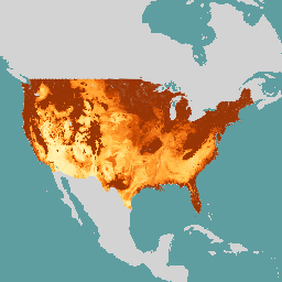
SOLUS (Soil Landscapes of the United States) is a national map product developed by the National Cooperative Soil Survey that is focused on providing a consistent set of spatially continuous soil property maps to support large scope soil investigations and land use decisions. SOLUS maps use a digital soil mapping framework that combines multiple sources of soil survey data with environmental covariate data and machine learning. SOLUS100 is 100 m spatial resolution. Each 100 m raster cell represents a 100 m by 100 m square on the ground with soil property values estimated at seven depths: 0, 5, 15, 30, 60, 100, and 150 cm.
It provides estimates for soil organic carbon, bulk density, pH, texture fractions (clay, silt, sand), calcium carbonate equivalent, and depth to an anylithic contact (e.g. bedrock).
Each soil property is represented by a separate image in this collection. For each soil property except depth to anylithic contact, bands are provided for 7 depths: 0, 5, 15, 30, 60, 100, and 150cm. For each depth, 4 layers are provided: predicted value, lower 95% confidence limit, upper 95% confidence limit, and a relative property index. For depth to anylithic contact, a single image provides the 4 layers representing depth in cm.
Image IDs correspond to soil properties:
soc: Soil organic carbon (%)bd: Bulk density (g/cm^3)phh2o: pH in waterclaytotal: Clay (%)silttotal: Silt (%)sandtotal: Sand (%)caco3: Calcium Carbonate (%)anylithicdpt: Depth to an Anylithic Contact (cm)
Bands
Bands
Pixel size: 100 meters (all bands)
| Name | Units | Pixel Size | Description |
|---|---|---|---|
r_0_cm_p |
100 meters | Predicted value of soil property at 0cm depth |
|
r_0_cm_l |
100 meters | Lower 95% confidence limit of soil property at 0cm depth |
|
r_0_cm_h |
100 meters | Upper 95% confidence limit of soil property at 0cm depth |
|
r_0_cm_rpi |
100 meters | Relative property index of soil property at 0cm depth |
|
r_5_cm_p |
100 meters | Predicted value of soil property at 5cm depth |
|
r_5_cm_l |
100 meters | Lower 95% confidence limit of soil property at 5cm depth |
|
r_5_cm_h |
100 meters | Upper 95% confidence limit of soil property at 5cm depth |
|
r_5_cm_rpi |
100 meters | Relative property index of soil property at 5cm depth |
|
r_15_cm_p |
100 meters | Predicted value of soil property at 15cm depth |
|
r_15_cm_l |
100 meters | Lower 95% confidence limit of soil property at 15cm depth |
|
r_15_cm_h |
100 meters | Upper 95% confidence limit of soil property at 15cm depth |
|
r_15_cm_rpi |
100 meters | Relative property index of soil property at 15cm depth |
|
r_30_cm_p |
100 meters | Predicted value of soil property at 30cm depth |
|
r_30_cm_l |
100 meters | Lower 95% confidence limit of soil property at 30cm depth |
|
r_30_cm_h |
100 meters | Upper 95% confidence limit of soil property at 30cm depth |
|
r_30_cm_rpi |
100 meters | Relative property index of soil property at 30cm depth |
|
r_60_cm_p |
100 meters | Predicted value of soil property at 60cm depth |
|
r_60_cm_l |
100 meters | Lower 95% confidence limit of soil property at 60cm depth |
|
r_60_cm_h |
100 meters | Upper 95% confidence limit of soil property at 60cm depth |
|
r_60_cm_rpi |
100 meters | Relative property index of soil property at 60cm depth |
|
r_100_cm_p |
100 meters | Predicted value of soil property at 100cm depth |
|
r_100_cm_l |
100 meters | Lower 95% confidence limit of soil property at 100cm depth |
|
r_100_cm_h |
100 meters | Upper 95% confidence limit of soil property at 100cm depth |
|
r_100_cm_rpi |
100 meters | Relative property index of soil property at 100cm depth |
|
r_150_cm_p |
100 meters | Predicted value of soil property at 150cm depth |
|
r_150_cm_l |
100 meters | Lower 95% confidence limit of soil property at 150cm depth |
|
r_150_cm_h |
100 meters | Upper 95% confidence limit of soil property at 150cm depth |
|
r_150_cm_rpi |
100 meters | Relative property index of soil property at 150cm depth |
|
r_cm_p |
cm | 100 meters | Predicted depth to anylithic contact in cm |
r_cm_l |
cm | 100 meters | Lower 95% confidence limit of depth to anylithic contact in cm |
r_cm_h |
cm | 100 meters | Upper 95% confidence limit of depth to anylithic contact in cm |
r_cm_rpi |
100 meters | Relative property index of depth to anylithic contact |
Terms of Use
Terms of Use
The SOLUS dataset is in the public domain and is available without restriction on use or distribution.
Citations
Nauman, T. W., Kienast-Brown, S., Roecker, S. M., Brungard, C., White, D., Philippe, J., & Thompson, J. A. (2024). Soil landscapes of the United States (SOLUS): developing predictive soil property maps of the conterminous United States using hybrid training sets. Soil Science Society of America Journal, 1-20. doi:10.1002/saj2.20769
DOIs
Explore with Earth Engine
Code Editor (JavaScript)
var soc = ee.Image('USDA/SOLUS100/V0/soc');
// NOTE: The following is equivalent:
// var soc = ee.ImageCollection('USDA/SOLUS100/V0')
//   .filter(ee.Filter.eq('system:index', 'soc'))
//   .first();
var soc_0_cm_p = soc.select('r_0_cm_p');

var visParams = {
  min: 0,
  max: 2000,
  palette: ['fff7bc', 'fee391', 'fec44f', 'fe9929', 'ec7014', 'cc4c02', '993404'],
};

Map.setCenter(-95, 38, 4);
Map.addLayer(soc_0_cm_p, visParams, 'Soil Organic Carbon 0-5cm');