- Veri Kümesi Kullanılabilirliği
- 2016-09-21T00:00:00Z–2016-09-21T00:00:00Z
- Veri Kümesi Üreticisi
- University of Minnesota Polar Geospatial Center
- Etiketler
Açıklama
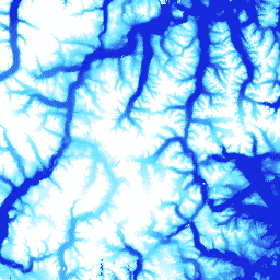
ArcticDEM, optik stereo görüntüleme, yüksek performanslı bilgi işlem ve açık kaynaklı fotogrametri yazılımı kullanarak Arktik'in yüksek çözünürlüklü ve yüksek kaliteli bir dijital yüzey modelini (DSM) otomatik olarak üretmek için National Geospatial-Intelligence Agency (NGA) ve National Science Foundation (NSF) tarafından başlatılan bir kamu-özel sektör girişimidir. Bitki örtüsü, ağaç örtüsü, binalar ve diğer yapay yüzey özellikleri bu kapsamdadır. 2 m'lik öğe, şeritler arasındaki projeksiyon farklılıkları nedeniyle tek bir mozaik yerine şeritlerden oluşan bir koleksiyondur.
Mozaiklenmiş DEM dosyaları, boş alanları ve kenar eşleştirme yapaylıklarını azaltmak için harmanlanmış ve yumuşatılmış en iyi kaliteli şerit DEM dosyalarından derlenir. Mutlak doğruluğu artırmak için filtrelenmiş IceSAT altimetre verileri raster dosyalarına uygulanmıştır.
Bantlar
Bantlar
Piksel boyutu: 2 metre (tüm bantlar)
| Ad | Birimler | Min. | Maks. | Piksel Boyutu | Açıklama |
|---|---|---|---|---|---|
elevation |
dk. | -416,45* | 5971,24* | 2 metre | Rakım |
Kullanım Şartları
Kullanım Şartları
National Science Foundation (PGC'nin birincil fon kaynağı) politikası, araştırmacıların tüm yayınlarda, web sayfalarında ve medya röportajlarında NSF desteğini belirtmelerini zorunlu kılar.
Kullanıcılar, Earth Engine'de PGC verilerini kullanarak PGC'yi ve NSF'nin sponsorluğunu alıntılamayı kabul eder. PGC tarafından sağlanan tüm üçüncü taraf verilerinin orijinal kaynağı da uygun şekilde belirtilmelidir.
Daha fazla bilgi için PGC'nin Onay Politikası'na bakın.
Alıntılar
Polar Geospatial Center tarafından DigitalGlobe, Inc. görüntüleriyle oluşturulan DEM'ler. Porter, Claire; Morin, Paul; Howat, Ian; Noh, Myoung-Jon; Bates, Brian; Peterman, Kenneth; Keesey, Scott; Schlenk, Matthew; Gardiner, Judith; Tomko, Karen; Willis, Michael; Kelleher, Cole; Cloutier, Michael; Husby, Eric; Foga, Steven; Nakamura, Hitomi; Platson, Melisa; Wethington, Michael, Jr.; Williamson, Cathleen; Bauer, Gregory; Enos, Jeremy; Arnold, Galen; Kramer, William; Becker, Peter; Doshi, Abhijit; D'Souza, Cristelle; Cummens, Pat; Laurier, Fabien; Bojesen, Mikkel, 2018, ArcticDEM, Harvard Dataverse, V1, [Date Accessed].
DOI'lar
Earth Engine ile Keşif
Kod Düzenleyici (JavaScript)
var dataset = ee.Image('UMN/PGC/ArcticDEM/V3/2m_mosaic');
var elevation = dataset.select('elevation');
var elevationVis = {
  min: -50.0,
  max: 1000.0,
  palette: ['0d13d8', '60e1ff', 'ffffff'],
};
Map.setCenter(-63.402, 66.368, 7);
Map.addLayer(elevation, elevationVis, 'Elevation');